
Understanding Insurgency in the North-East India
India’s internal security map has two theatres that are, at first glance, very different — the misty hills of the North-East and the snow-bound valleys of Jammu and Kashmir — yet both teach the same underlying lesson.
When a population’s sense of identity is not woven into the idea of the nation, when geography isolates a people from the mainland, and when a hostile neighbour is ready to supply arms and sanctuary, the result is armed rebellion that can outlive generations.
This chapter begins with the North-East, the older and more intricate of the two theatres. The treatment of Jammu and Kashmir follows in a later instalment of this same chapter.
Before entering the detail, hold on to a simple mental frame. Insurgency here is not one disease but a family of diseases — some driven by the demand for a separate nation, some by the demand for a separate state or homeland within India, and some by raw ethnic rivalry over land and jobs. Keeping these three strands apart is the single most useful habit an aspirant can build for this topic.
Setting the Context
The Land, the People and the Siliguri Corridor
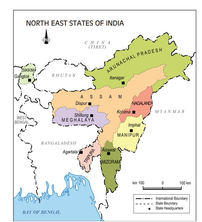
The North-Eastern Region, or NER, is made up of eight states — the seven contiguous states of Arunachal Pradesh, Assam, Manipur, Meghalaya, Mizoram, Nagaland and Tripura, historically called the Seven Sisters, together with Sikkim, the ‘brother’ state added to the grouping after it joined the Union.
The region occupies roughly 8 per cent of India’s geographical area but carries under 4 per cent of its population, and within that population Assam alone accounts for about two-thirds. So the demographic weight of the region is small, but its strategic weight is enormous — a mismatch that runs through every security question here.
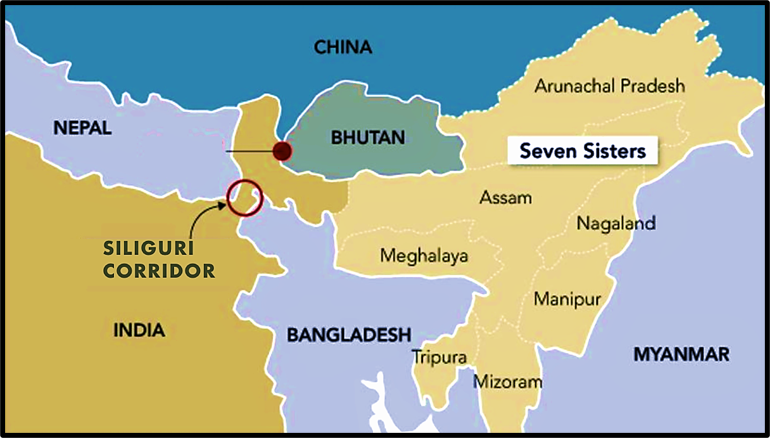
The most important geographical fact of the entire region is one thin sliver of land. The North-East is joined to the Indian mainland only through the Siliguri Corridor in northern West Bengal — a strip barely 20 to 22 kilometres wide at its narrowest, wedged between Nepal, Bhutan and Bangladesh.
Its shape has earned it the nickname the ‘Chicken’s Neck’. Everything that moves between mainland India and the North-East — road, rail, fuel, troops — is funnelled through this bottleneck. A single point of failure of this kind has no parallel elsewhere in the country, and it colours how Delhi thinks about the whole region.
The second geographical fact is the border. About 99 per cent of the region’s boundary is international, and it is shared with as many as five countries. The lengths are worth committing to memory in approximate terms.
| Neighbour | Approx. length of NER border | Security significance |
| Bangladesh | ~1,880 km | Illegal migration; sanctuary for Tripura and Meghalaya outfits in earlier decades |
| Myanmar | ~1,643 km | Sanctuary and training camps for Naga and Assam outfits; Golden Triangle drug spillover |
| China | ~1,346 km | Historical arms and moral support to insurgents; contested Arunachal boundary |
| Bhutan | ~516 km | Former ULFA and NDFB camps, cleared by ‘Operation All Clear’, 2003 |
| Nepal | ~99 km | Transit route for cadres and contraband |
Add to this a terrain that is overwhelmingly hilly, forested and rain-soaked in every state except the Assam plains, and a settlement pattern that is over four-fifths rural, and the picture is complete: a small, remote, tribal-majority region strung along a difficult international frontier, tied to the rest of India by a single narrow thread.
Why the North-East is a Distinct Security Theatre
The North-East is not simply another disturbed area; it is a security theatre of its own kind, and treating it like the mainland is precisely the mistake that has been made in the past. Four features set it apart.
- Extraordinary human diversity. The region is home to more than two hundred distinct tribes and sub-tribes speaking several hundred languages and dialects — one of the densest concentrations of ethnic diversity anywhere in the world. Each group guards its land, language and customary law fiercely, so a policy that suits one community can alarm the next.
- A frontier, not a heartland. For most of its recorded history the region looked eastward and northward — towards Myanmar, Tibet and South-East Asia — rather than towards the Gangetic plains. Its natural trading partners were Bhutan and Burma. This eastward orientation, deliberately reinforced under colonial rule, means the emotional pull of ‘mainland India’ has always been weaker here than elsewhere.
- A gateway with two faces. The same location that makes the region vulnerable also makes it valuable. It is India’s land bridge to South-East Asia and the physical anchor of the Act East Policy, rich in tea, oil, timber, and an estimated 50,000 MW of hydropower potential, and it sits inside the Indo-Burma biodiversity hotspot. Security and opportunity are two sides of the same coin here.
- Stable anarchy. A memorable phrase captures the peculiar equilibrium of the region — a condition of ‘stable anarchy’, in which the formal institutions of the state continue to function on paper while, on the ground, insurgent groups run parallel systems of taxation, justice and authority. The state is present but not always sovereign.
| Anchor the map in your mind Three images unlock this whole chapter: the Chicken’s Neck (the region’s lifeline and its greatest vulnerability), the eastward-facing frontier (why identity here is weakly tied to the mainland), and stable anarchy (why ‘peace’ and ‘insurgency’ can coexist for decades). Every later fact hangs off one of these three pegs. |
Historical Background
To understand why the North-East rebelled, you must understand how it was governed — first by the British, who deliberately kept it apart, and then by independent India, which had to knit a deliberately-separated frontier into a modern nation almost overnight. The seeds of insurgency were sown in that transition.
Colonial Policy — the Inner Line, Excluded and Partially Excluded Areas
The British approach to the North-Eastern hills can be summed up in one word: insulation. Having taken nearly a century to annex the region after the conquest of Assam in 1826, the colonial state chose not to integrate the hill tribes but to fence them off from the plains and from the currents of Indian politics.
The first instrument was the Inner Line. Under the Bengal Eastern Frontier Regulation, 1873, the British drew an administrative line beyond which no outsider — including other Indians — could pass or acquire land without a permit. Dressed up as protection for the tribes, its real purpose was to safeguard colonial commercial interests in tea, oil and timber by keeping the frontier population sealed and quiet. This is the ancestor of today’s Inner Line Permit (ILP) system.
The second instrument came with the Government of India Act, 1935, which formally divided the hill areas of Assam into two protected categories, deliberately kept outside the reach of the elected provincial legislature.
| Category under the 1935 Act | Areas covered | Effect |
| Excluded Areas | Naga Hills, Lushai Hills (now Mizoram), North Cachar Hills | Governor ruled directly; provincial ministry and laws had no jurisdiction |
| Partially Excluded Areas | Khasi & Jaintia Hills, Garo Hills, Mikir Hills | Provincial legislation applied only selectively, at the Governor’s discretion |
Two consequences flowed from this insulation, and both matter for security.
- First, the freedom struggle barely touched the hills; the tribes never lived through the shared experience of fighting for a free India, so the emotional idea of belonging to India never took root.
- Second, the British actively encouraged Christian missionaries to work in the hills. The missionaries brought schools, hospitals and literacy — Nagaland and Mizoram became highly educated as a result — but they also deepened the cultural distance between the hills and the Hindu-Muslim plains, and helped keep nationalist ideas out.
When the British left in 1947, they left behind a frontier that was educated, Christianised, self-aware and psychologically separate from the rest of India.
Integration of the Frontier and the Origins of the Naga Movement
At Independence the entire North-East was, administratively, almost a single unit: the large province of Assam, plus the princely states of Manipur and Tripura and the frontier tract that would become Arunachal Pradesh.
Independent India now faced the delicate task of absorbing a region the British had spent a century keeping separate. The Constitution’s answer was the Sixth Schedule, a special framework of Autonomous District and Regional Councils giving hill tribes self-rule over land, forests and customary law — an enlightened design meant to reassure the tribes that integration would not mean absorption.
But reassurance came too late for the Nagas, who had already moved towards separation. The chronology is as follows:
- 1946 — the Naga National Council (NNC) was formed under Angami Zapu Phizo to articulate the Naga political demand.
- 14 August 1947 — one day before India’s independence, the NNC declared Naga independence, rejecting inclusion in the Indian Union.
- 1951 — the NNC conducted a ‘plebiscite’ in which it claimed that virtually 99 per cent of Nagas supported a sovereign Nagaland.
- 1955–56 — the movement turned armed; a parallel government was proclaimed and the Indian Army was sent in, opening India’s oldest running insurgency.
| Case Study — The Nine Point Agreement and a lost chance, 1947 On 26 June 1947, the Governor of Assam and moderate Naga leaders reached the Nine Point Agreement, promising the Nagas judicial, executive and legislative autonomy for ten years, after which they could review the arrangement. The two sides, however, read the same document differently: the Nagas believed the tenth year gave them the right to choose sovereignty, while the Indian side read it as district autonomy within the Constitution. The Constituent Assembly declined to ratify it. That single failure of interpretation pushed the moderates aside, handed the initiative to Phizo’s hardliners, and set the template for every later Naga negotiation — including the unfinished peace talks of today. |
The Naga story also carries the lesson that firmness and reconciliation can work together. Even as it refused to negotiate sovereignty and contained the armed revolt by 1957, the Centre simultaneously courted moderate, non-violent leaders such as Dr Imkongliba Ao. That twin-track approach produced the state of Nagaland in 1963, India’s sixteenth state — a genuine achievement, even though a residual insurgency has smouldered ever since.
State Reorganisation and the Making of the Eight States
The central grievance that turned discontent into rebellion across the hills was the fear of being swallowed by the Assamese plains. When Assamese was declared the sole official language of the state in 1960, the hill tribes read it as forced ‘Assamisation’ — a threat to their language, jobs and identity.
Their political answer was the All Party Hill Leaders Conference (APHLC) of 1960, which united the hill districts behind a single demand: separate states within the Indian Union.
What followed over the next quarter-century was one of the great exercises in peaceful internal boundary-making in the democratic world — the steady breaking-up of ‘greater Assam’ into a mosaic of ethnically-rooted states, mostly through negotiation rather than war. The sequence is best carried as follows:
| State | Attained statehood | Carved from / earlier status |
| Nagaland | 1963 | Naga Hills–Tuensang area of Assam |
| Meghalaya | 1972 | Autonomous ‘state within Assam’ (1969), then full state |
| Manipur | 1972 | Princely state, then Union Territory |
| Tripura | 1972 | Princely state, then Union Territory |
| Sikkim | 1975 | Former protectorate; joined the Union as a state |
| Arunachal Pradesh | 1987 | North-East Frontier Agency (NEFA) |
| Mizoram | 1987 | Lushai Hills district of Assam |
Read this table as a political safety-valve. Wherever a distinct community’s aspiration was met with a state of its own — Meghalaya, Mizoram — the pressure for secession generally eased.
Wherever the ethnic map was too tangled to be neatly redrawn — Manipur, the Bodo areas of Assam — the demands could not all be satisfied, and grievance persisted.
State reorganisation defused some insurgencies but planted the seeds of others, because every new boundary created a fresh set of minorities who now wanted homelands of their own. That paradox is the bridge to the next topic
Factors Responsible for Insurgency
Why has this small, beautiful region produced more insurgent groups than any comparable part of India? No single cause explains it. Insurgency here is best understood as the product of several forces acting together — geography and identity providing the tinder, migration and underdevelopment providing the spark, and porous borders providing the oxygen.
It is useful to lay the drivers out along familiar analytical dimensions, because the examiner rewards exactly this kind of multi-dimensional treatment.
Tribal Identity, Autonomy and Competing Ethnic Homelands
At the very core of North-Eastern insurgency lies an identity crisis. Each tribe defines itself against outsiders, and ‘outsider’ can mean the distant Indian state, the neighbouring plains community, or even a different hill tribe.
Three related anxieties operate at once: the fear of losing cultural identity to assimilation, the demand for political autonomy or self-rule, and competition between groups for the same territory.
The last of these is the most intractable, because the ethnic homelands overlap. The Naga demand for a ‘Greater Nagalim’ — uniting all Naga-inhabited areas under one administration — directly collides with the territorial integrity of Manipur, Assam and Arunachal Pradesh.
The Bodo demand for a homeland in Assam runs into the reality that non-Bodos outnumber Bodos in the very area claimed. When two peoples claim one land, satisfying one inflames the other. This is why the region has seen not only secessionist insurgency against India but also brutal ethnic conflict between communities.
Migration and Demographic Anxiety
If identity is the tinder, demographic change is the accelerant. Decades of migration — first as a colonial labour frontier, then across the porous border from East Pakistan and later Bangladesh — have altered the population balance of the plains districts, above all in Assam and Tripura.
Tripura offers the starkest example: the indigenous tribal population, once a clear majority, was reduced over time to a minority in its own homeland, a ‘demographic inversion’ that fed the insurgency of the 1990s.
The anxiety is not only about numbers; it is about land, jobs, votes and language. Indigenous communities fear that migrants will acquire their land, capture their share of employment, tilt electoral outcomes and dilute their culture.
This fear is the thread that ties together the Assam Movement, the demand for the Inner Line Permit, and the periodic explosions of communal violence in the Bodo areas. It is a driver we will meet again in detail when we examine citizenship, the Assam Accord and the NRC in a later section; here it is enough to register it as a root cause of unrest, not merely a law-and-order problem.
Porous Borders, Difficult Terrain and External Sanctuary
An insurgency needs three things to survive: recruits, weapons and a place to hide. The geography of the North-East supplies all three.
The terrain — long forested ranges and deep river valleys — gives natural cover to guerrillas and frustrates security operations.
The borders are porous and, crucially, run through communities that are ethnically identical on both sides: a Naga or a Mizo can cross into Myanmar and be among kinsmen, making sanctuary effortless.
- Myanmar has historically hosted camps and training facilities of the Naga and Assam-based outfits, whose cadres slip across to escape counter-insurgency sweeps.
- Bangladesh long sheltered the Tripura and Meghalaya groups, though its posture hardened after 2009; Bhutan once hosted ULFA and NDFB camps until ‘Operation All Clear’ in 2003.
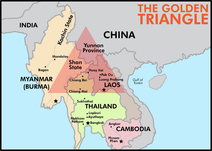
- Proximity to the Golden Triangle (Myanmar–Laos–Thailand) turns the region into a drug-smuggling corridor, and narcotics money has become a standing source of insurgent funding — a theme developed in the treatment of drug trafficking that follows.
- There is a long record of external moral, material and arms support to these groups, with arms markets in South-East Asia as the source and allegations of a covert hand from across the northern border.
The lesson is that the North-Eastern insurgencies have rarely been purely internal. Cross-border sanctuary is the oxygen that has kept them alive, which is why the security response has always had to be as much diplomatic as military — a point examiners like to test through the lens of border management.
Underdevelopment, Connectivity Deficit and Economic Isolation
For decades the North-East was, in effect, an economic cul-de-sac. Partition amputated its natural trade routes to Chittagong and East Bengal, leaving it dependent on the fragile Chicken’s Neck. The result was a chronic connectivity deficit — thin roads, late-arriving railways, unreliable power — and, with it, weak industry and few jobs for an increasingly educated youth.
This matters for security in a very direct way. A young person with education but no employment is exactly the profile an insurgent recruiter looks for; as observers of the region bluntly note, ‘insurgents are born primarily out of joblessness.’ Underdevelopment also breeds a sense of being left behind by a country racing ahead elsewhere, converting economic grievance into political alienation.
The region’s paradox — abundant natural wealth in tea, oil, timber and hydropower sitting alongside stubborn poverty — only sharpens the sense of resources being extracted while prosperity stays away.
Political Mismanagement and the Psychology of Neglect
Governance failures have repeatedly turned manageable discontent into armed revolt. The imposition of Assamese as the sole official language in 1960, the slow and grudging response to autonomy demands, episodes of corruption among local elites, and the heavy hand of security laws have all, at different moments, told the people of the region that their concerns were an afterthought in Delhi.
Underlying all of this is a psychology of neglect — captured in the recurring complaint that the North-Easterner is not treated as a full Indian, is mocked for distinct facial features, and sees his culture ignored in the national story.
Distance from Delhi, thin representation in Parliament, and years of being administered rather than engaged have fed a feeling of second-class citizenship. Insurgency, in this reading, is partly the language a neglected periphery uses to make the centre listen. The corrective is not only military or economic but emotional and political — a genuine sense of belonging.
Why Armed Insurgency Survived So Long — the Analytical Core
The most demanding question the examiner asks about this region is not what caused insurgency, but why it survived for so long when insurgencies elsewhere burned out in years. The answer lies in a self-reinforcing ecosystem in which each factor feeds the next.
- Sanctuary made defeat impossible. With safe havens and kinsmen across an ethnically-shared, porous border, groups could always retreat, regroup and return. A guerrilla who cannot be cornered cannot be finished.
- Overlapping ethnic claims made settlement impossible. Because homelands overlap, every accord that satisfied one group alarmed another, so peace with the Nagas unsettled the Meiteis and Kukis, and peace with the Bodos unsettled the non-Bodos. There was rarely a settlement that closed the file for everyone.
- An economy of violence made it self-financing. Extortion, ‘taxation’, and drug and arms smuggling turned insurgency into a livelihood, giving cadres a material stake in keeping the conflict alive even after the political cause had faded.
- Faction and fragmentation renewed the supply. Groups split endlessly — over ceasefires, leadership and ideology — and each splinter needed a fresh war to justify itself, so the death of one outfit often gave birth to two.
- Alienation kept the recruitment pool full. As long as young people felt neglected, jobless and culturally slighted, there was never a shortage of recruits, whatever the fate of any single group.
Set these together and the persistence explains itself: the North-East offered insurgency sanctuary that prevented military defeat, a tangle of claims that prevented political settlement, a war economy that funded itself, a habit of fragmentation that regenerated the groups, and a reservoir of alienated youth that replenished them.
Break any one link and an insurgency weakens; the tragedy of the region was that, for decades, all five held together at once. It is precisely because these links have finally begun to loosen — sanctuaries squeezed, accords signed, development arriving — that the last decade has seen a real, if incomplete, de-escalation, a theme taken up in the assessment of the government’s response.
| Current Status (as of July 2026) Overall trajectory — de-escalation. Insurgency-related violence across the North-East has fallen sharply over the past decade, with large reductions in incidents, security-force casualties and civilian deaths, and a wave of surrender and peace agreements. The region is, on the whole, more peaceful than at any time since the 1990s. The exception — Manipur. The Meitei–Kuki-Zo ethnic conflict that erupted in May 2023 remains unresolved. Tens of thousands were displaced into relief camps, and President’s Rule was imposed on 13 February 2025 and has since been extended. Manipur is today the single most serious flashpoint in the region and a live reminder that ethnic, not merely secessionist, conflict is now the harder problem. Inner Line Permit. The ILP regime now covers four states — Arunachal Pradesh, Mizoram, Nagaland and, since December 2019, Manipur — reflecting the enduring strength of demographic anxiety as a political force. Cross-border uncertainty. Instability in Myanmar since 2021 and the changed political situation in Bangladesh after 2024 have reopened questions of sanctuary and spillover that had seemed settled, keeping the border dimension firmly on the agenda. |
This closes the foundation of the North-Eastern theatre — its context, its history and the forces that drive it. The state-by-state picture, the cross-border dimension, the migration-and-citizenship debate, and the full architecture of the government’s response are developed in the sections that follow.