
Satellites and Sensors
Introduction to Satellites
Long before we had the word ‘satellite’, the Moon was doing its job — faithfully orbiting Earth, influencing tides, and guiding ancient navigators. Today, humanity has sent over 9,000+ artificial satellites into orbit (though not all are active).
These metal messengers in the sky touch almost every aspect of modern life — from weather forecasts to GPS navigation, from DTH television to missile guidance.
Definition:
A satellite is an object that orbits another object in space. The Moon is Earth’s natural satellite. Artificial satellites are human-made objects deliberately placed into orbit for specific missions — communication, observation, navigation, defence, science, and more.
Key Components of Every Satellite
- Payload: The ‘brain’ of the mission — cameras, sensors, transponders. E.g., a weather satellite’s payload is its radiometer.
- Power System: Solar panels + batteries. No power = no satellite. Most satellites use photovoltaic (PV) solar cells.
- Propulsion System: Small thrusters for orbit corrections and attitude adjustments (not the launch rocket).
- Communication System: Antennas to uplink commands from ground and downlink data to Earth.
- Control System: Onboard computers managing navigation, pointing, and operations.
💡Think of a satellite as a very expensive, solar-powered smartphone orbiting at 500 km altitude — it has a camera (payload), battery (power), tiny rockets (propulsion), antenna (communication), and processor (control). Everything miniaturised, hardened against radiation, and running for 10-15 years without a service call.
Types of Satellites
Based on Purpose
| Type | Function | Indian Example | Global Example |
| Communication | TV, radio, internet, telephone relay | INSAT, GSAT series | Intelsat, Starlink |
| Earth Observation | Land mapping, agriculture, disaster mgmt | Cartosat, RISAT, EOS-04 | Landsat, Sentinel |
| Navigation | Positioning, timing, GPS services | NavIC (IRNSS) | GPS, GLONASS, Galileo, BeiDou |
| Weather | Weather patterns, atmospheric monitoring | INSAT-3D, Kalpana-1 | GOES, Meteosat |
| Astronomical | Observing celestial objects from space | AstroSat | Hubble, JWST |
| Military | Surveillance, reconnaissance, secure comms | EMISAT, GSAT-7A | KH-Series, Gaofen |
| Biosatellites | Study effects of space on living organisms | (Research phase) | NASA Biosat |
| Space Stations | Habitable platforms for long-term research | Gaganyaan (upcoming) | ISS, Tiangong |
⚠ EMISAT is India’s electronic intelligence (ELINT) satellite — it intercepts enemy radar signals.
GSAT-7A is the ‘Angry Bird’ satellite for the Indian Air Force.
AstroSat (2015) is India’s first dedicated multi-wavelength space observatory.
Based on Operational Lifespan
- Short-Term Satellites: Missions lasting months to 2 years. E.g., Chandrayaan-1 (lunar orbit, ~1 year), Mangalyaan, CubeSats.
- Long-Term Satellites: Designed for years to decades. E.g., INSAT series (15+ years), Hubble Space Telescope (1990–present), GOES weather satellites.
Based on Ownership
- Civilian: Science, meteorology, communication. E.g., INSAT, GSAT — operated by ISRO/DoS.
- Military: Defence and surveillance. E.g., EMISAT, GSAT-7 (Indian Navy’s ‘Rukmini’ satellite).
- Commercial: Private sector for internet, broadcasting. E.g., Starlink (SpaceX), OneWeb (UK).
Based on Size — The Satellite Size Spectrum
From bus-sized behemoths to postage-stamp nanosatellites — modern space technology spans an enormous size range:
| Category | Mass | Example |
| Large Satellite | > 1,000 kg | INSAT-4B (2,168 kg), GSAT-11 (5,854 kg — heaviest ISRO satellite) |
| Medium Satellite | 500 – 1,000 kg | RISAT-2B, EOS series |
| Minisatellite | 100 – 500 kg | IMS-1 (India) |
| Microsatellite | 10 – 100 kg | Jugnu (3 kg, IIT Kanpur), STUDSAT |
| Nanosatellite | 1 – 10 kg | CubeSats (most common format) |
| Picosatellite | 0.01 – 1 kg | Femto-experimental spacecrafts |
| Femtosatellite | 0.001 – 0.01 kg | Experimental only, not yet operational |
CubeSat — Democracy in Space
CubeSats represent the democratisation of space. A CubeSat is a standardised small satellite based on a 10 cm × 10 cm × 10 cm cube (1U) weighing ~1.33 kg per unit. They can be stacked: 2U, 3U, 6U, 12U, etc.
💡Before CubeSats, only government agencies and billion-dollar corporations could launch satellites. Today, university students, startups, and even high schools can build and launch them. India’s PSLV has launched hundreds of CubeSats from dozens of countries. This is the ‘smartphone revolution’ of space — miniaturisation democratising access to orbit.
Beyond Satellites — High-Altitude Platform Systems (HAPS)
HAPS are unmanned airships, balloons or aircraft that hold station in the stratosphere (around 20 km) — higher and longer-lasting than drones, cheaper and more flexible than satellites — for persistent surveillance, communications relay and earth observation.
India: DRDO’s Aerial Delivery R&D Establishment (ADRDE), Agra flew a stratospheric airship to ~17 km in May 2025; a 2026 trial reached 21 km and held 20 km for over 30 minutes.
Sensors in Space Technology
Sensors are the sensory organs of a satellite — without them, the satellite is blind. Just as humans use eyes, ears, and skin to perceive the world, satellites use optical, thermal, radiation, magnetic, inertial, and radar sensors to ‘perceive’ Earth and space.
Optical Sensors — The Eyes of Satellites
Optical sensors detect electromagnetic radiation in the visible, infrared, and ultraviolet spectrum. They are the most widely used sensors in Earth observation satellites.
| Sensor Type | How It Works | Key Application | Indian Example |
| CCD Sensors | Convert light into electrical signals | High-resolution photography | Cartosat-2 cameras |
| Imaging Sensors | Convert photons to images across wavelengths | Multi-spectral Earth imaging | ResourceSat, EOS-04 |
| Spectrometers | Split light into wavelengths to identify chemicals | Atmospheric chemistry, mineral identification | Chandrayaan-1 payload |
| LIDAR | Laser pulses measure distance and create 3D maps | Terrain mapping, atmospheric studies | ICESat (NASA) concept |
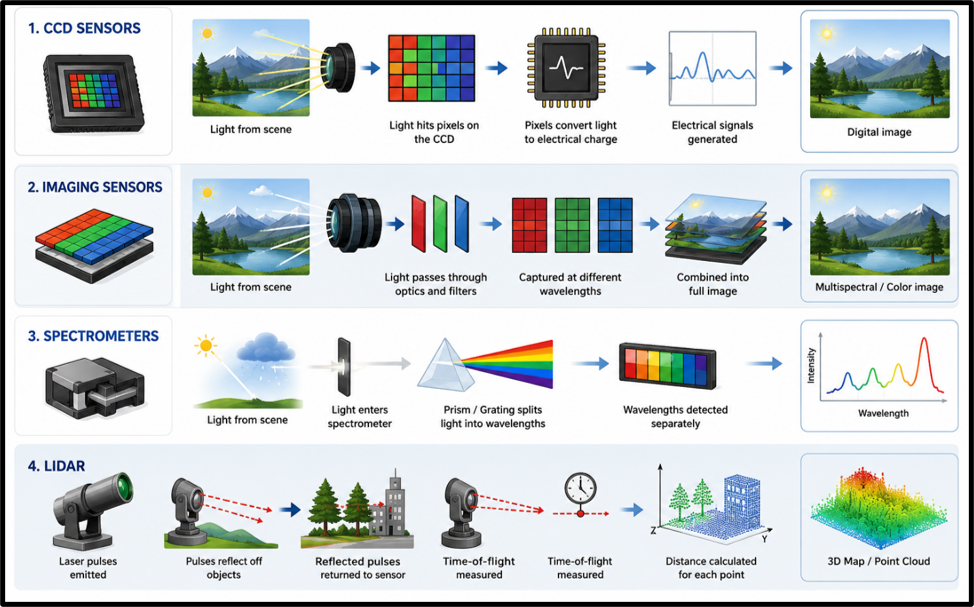
Optical: Best for clear-sky, daytime imaging. Limitation: clouds and darkness are kryptonite.
- Advantages: High resolution, passive (no energy emission), wide spectral range, cost-effective.
- Disadvantages: Cannot see through clouds or at night, limited depth penetration.
💡RISAT-1 (Radar Imaging Satellite) was launched precisely because Cartosat (optical) could not photograph flood-affected or cloud-covered areas. Radar fills the gap where optical sensors fail.
Always remember: optical sensors = sunshine and clear skies; radar = works regardless.
Thermal Sensors — Seeing in the Dark
Every object above absolute zero emits infrared (heat) radiation. Thermal sensors detect these emissions, allowing satellites to ‘see’ temperature variations even in complete darkness or through cloud cover.
| Type | Function | Use Case |
| IR Sensors | Detect infrared radiation for temperature mapping | Fire detection, weather, night imaging |
| Bolometers | Measure tiny infrared energy changes | Astrophysics, climate research |
| Thermocouples | Convert temperature difference to voltage | Spacecraft thermal monitoring |
| Pyrometers | Remote temperature measurement via IR emission | Volcanic activity, industrial monitoring |
| Thermistors | Temperature-sensitive resistors | Spacecraft internal thermal regulation |
- Advantages: Day AND night operation, weather-independent, passive sensing, detects hidden heat sources, high sensitivity.
- Disadvantages: Lower resolution than optical sensors, calibration challenges, limited material differentiation.
📌 Key Fact: India’s forest fire detection, crop health monitoring (NDVI), and urban heat island studies all rely on thermal/infrared sensors aboard satellites like ResourceSat and EOS-06.
Radiation Sensors — Guarding Astronauts and Spacecraft
Space is bathed in cosmic rays, solar radiation, and high-energy particles — all invisible but potentially deadly to electronics and humans. Radiation sensors are the ‘shield monitors’ of spacecraft.
- Geiger-Müller Tubes: Detect beta and gamma radiation. The classic ‘click-click’ radiation detector.
- Scintillation Detectors: Convert high-energy radiation into light pulses for measurement. Used in gamma-ray astronomy.
- Solid-State Radiation Detectors: Semiconductor-based (silicon/germanium). Measure energy of charged particles precisely.
- Dosimeters: Cumulative radiation exposure monitors. Essential for ISS astronaut safety.
- Cherenkov Detectors: Detect ultra-high-energy cosmic rays via blue light emission when particles exceed light speed in a medium.
- Advantages: Space radiation monitoring, early warning for solar storms, essential for astronaut safety.
- Disadvantages: Sensor degradation over time, interference from background radiation, limited to specific radiation types.
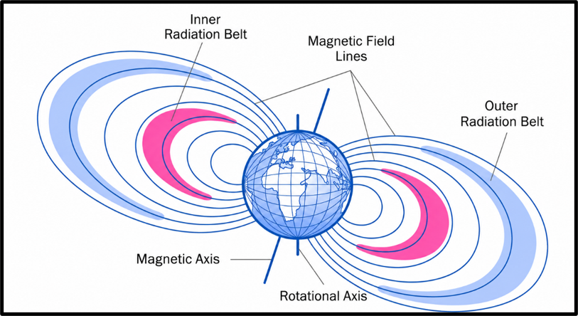
💡The Van Allen Radiation Belts — two donut-shaped zones of trapped high-energy particles around Earth — are monitored by radiation sensors aboard spacecraft like NASA’s Van Allen Probes. ISRO’s satellites in MEO orbits must be hardened against this radiation.
Magnetic Sensors — Cosmic Compass
Magnetic sensors measure magnetic fields in space — both Earth’s magnetosphere and distant planetary fields. They serve as cosmic compasses for spacecraft navigation.
- Fluxgate Magnetometers: High-precision weak field measurement. Standard in planetary exploration missions.
- Hall Effect Sensors: Measure field strength/direction via voltage. Used in satellite attitude control.
- Magnetoresistive Sensors: Detect field variations via resistance change.
- SQUID Magnetometers: Superconducting Quantum Interference Device — most sensitive magnetic sensors ever built. Used in deep-space exploration.
- Advantages: Essential for navigation, high sensitivity, low power consumption.
- Disadvantages: Susceptible to onboard electronic interference, complex calibration.
📌 Key Fact: India’s Chandrayaan-3 Pragyan rover carried a Rover Alpha Particle X-ray Spectrometer (APXS) and Laser-Induced Breakdown Spectroscope (LIBS) — types of spectral sensors. Vikram lander carried temperature sensors (ChaSTE) and seismic sensors (ILSA).
Inertial Sensors — The Inner Compass
Inertial sensors measure acceleration and angular velocity — they tell the spacecraft ‘how fast you are turning’ and ‘which direction you are moving’ without any external reference signal.
- Gyroscopes: Measure angular velocity (rate of rotation). Used for attitude determination.
- Accelerometers: Measure linear acceleration. Essential for launch vehicle guidance.
- Inertial Measurement Units (IMUs): Combined gyroscopes + accelerometers for complete motion sensing. The ‘brain’ of rocket guidance.
💡The Hubble Space Telescope famously had gyroscope failures. When its gyroscopes broke, it could no longer point precisely at distant stars. NASA’s servicing missions replaced them — but for future unserviceable satellites, reliable gyroscopes are a mission-critical design priority.
Radar Sensors — The All-Weather Eye ⭐
Radar stands for Radio Detection and Ranging. Unlike optical sensors that depend on sunlight and clear skies, radar transmits its own radio waves and analyses the reflection — giving it the superpower of working in all weather, day and night, through clouds and vegetation.
| Radar Type | How It Works | UPSC-Relevant Use | Example |
| SAR (Synthetic Aperture Radar) | Uses spacecraft motion to simulate large antenna; microwave frequency | High-res surface imaging, disaster monitoring | RISAT-1, RISAT-2 (India), Sentinel-1 |
| Ground-Penetrating Radar (GPR) | Low-frequency waves penetrate surface | Subsurface archaeology, ice thickness | Mars Reconnaissance Orbiter SHARAD |
| Altimetry Radar | Times radar pulse return to measure height | Ocean surface mapping, glacier monitoring | Jason-3, SARAL/AltiKa (India-France) |
| Scatterometer | Measures radar wave scattering | Ocean wind measurement | SCATSAT-1 (India) |
| Doppler Radar | Frequency shift of reflected waves measures velocity | Weather forecasting, storm tracking | IMD Doppler Weather Radars (DWR) |
⚠ RISAT (Radar Imaging Satellite) series is India’s SAR satellite — it can photograph through clouds and at night, making it crucial for flood monitoring, border surveillance, and disaster response. RISAT-2B (2019) and RISAT-2BR1 (2019) use X-band SAR.
Active vs Passive Sensors — The Fundamental Divide
The entire sensor world divides into two camps: those that shout (active) and those that listen (passive).
| Feature | Passive Sensors | Active Sensors |
| Energy Source | Rely on natural energy (sunlight, cosmic radiation) | Emit their own energy (radar, laser, microwave) |
| Examples | Optical cameras, IR sensors, Radiometers, Magnetometers | SAR, LIDAR, Radar Altimeter, Doppler Radar |
| Weather Dep. | LIMITED — clouds and darkness affect performance | ALL-WEATHER — rain, fog, night — no problem |
| Penetration | Cannot penetrate clouds, vegetation, or soil | Can penetrate clouds, vegetation, dry soil |
| Resolution | Lower resolution in some conditions | High resolution (SAR, LIDAR provide excellent detail) |
| Energy Use | LOW — no signal emission needed | HIGH — continuous signal transmission required |
| Stealth | STEALTHY — does not emit, hard to detect | DETECTABLE — emissions can be sensed by enemy |
| Cost | Generally lower | Generally higher; complex hardware |
| Best For | Clear-sky imaging, navigation, astronomy | Disaster monitoring, surveillance, navigation in all conditions |
💡 A nice way to remember: Active sensors are like a flashlight — they carry their own light and illuminate the scene. Passive sensors are like your eyes — they only work when there is external light (the Sun). At night or in fog, your eyes (optical sensors) fail, but a flashlight (radar/active) works perfectly.