
Orbits in Space Technology
Imagine you are standing on a tall hill and you throw a stone horizontally. It falls to the ground due to gravity. Now, what if you threw it so fast that as it falls, the Earth’s surface curves away beneath it? The stone would never hit the ground — it would keep going around the Earth forever. That, is an orbit. This elegant idea, which seems almost magical, is the foundation of all our satellites, GPS systems, and space missions. Let us understand it fully.
What is an Orbit?
Definition: An orbit is the curved path that an object in space (such as a star, planet, moon, asteroid or spacecraft) takes around another object due to gravity. Gravity pulls objects with mass toward each other. When two objects come close enough and move at the right speed, they begin to orbit each other.
💡Think of it this way: a satellite is essentially falling towards Earth all the time — but it is moving sideways so fast that the Earth keeps curving away. It is a perpetual fall that never ends. The first person who understood this deeply was Isaac Newton himself.
Factors Affecting Orbit and Satellite Functionality
Four key parameters define any satellite orbit. Think of them as the ‘ID card’ of every satellite:
- Altitude: The height above Earth directly determines coverage area, speed, signal latency, and atmospheric decay. Low-altitude orbits are fast with smaller coverage but better imaging; high-altitude orbits are slower with wider coverage.
- Eccentricity: This measures how ‘oval-shaped’ the orbit is. A perfect circle has eccentricity = 0. As the orbit elongates (becomes more elliptical), eccentricity approaches 1. Circular orbits give consistent coverage; elliptical orbits allow prolonged coverage over specific regions.
- Inclination: The angle between the satellite’s orbital plane and Earth’s equator. A 0° inclination means the satellite orbits above the equator. A 90° inclination (polar orbit) means it flies over the poles — thus scanning every part of Earth.
- Orbital Period: The time taken to complete one full orbit. It ranges from ~100 minutes (LEO) to 24 hours (geostationary). Kepler’s Third Law connects this directly to altitude.
Perigee and Apogee
When a satellite orbits in an elliptical path, its distance from Earth is not constant. There are two special points:
- Perigee: The closest point to Earth in an elliptical orbit. At perigee, the satellite is moving fastest (Kepler’s 2nd Law).
- Apogee: The farthest point from Earth. At apogee, the satellite slows down.
💡A beautiful analogy: think of a pendulum. At its lowest point (like perigee), it moves fastest. At the highest point of its swing (like apogee), it momentarily slows. Orbital mechanics mirrors everyday physics.
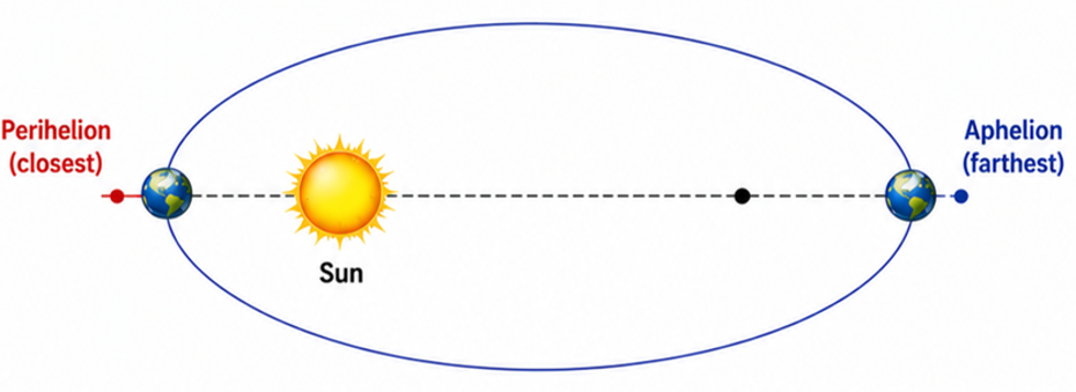
Similarly, for planets orbiting the Sun: the closest point is called Perihelion (Earth reaches it around January 3rd, at ~147.3 million km) and the farthest is Aphelion (around July 4th, at ~152.1 million km). This is why Northern Hemisphere winters are slightly milder — Earth is actually closer to the Sun!
Laws Governing the Orbits
Two sets of laws govern all orbital motion. Together, they form the complete theoretical framework of satellite science:
- Newton’s Laws of Motion — describe how force, mass, and acceleration interact
- Kepler’s Laws of Planetary Motion — describe the shape, speed, and timing of orbits
Types of Velocities Associated with Satellites
| Velocity Type | Definition | Key Value / Note |
| Orbital Velocity | Speed at which a satellite must travel to maintain its orbit around Earth | ~7.8 km/s at LEO altitude |
| Escape Velocity | Minimum speed to break free from Earth’s gravitational pull without further propulsion | ~11.2 km/s for Earth |
| Delta-v (Δv) | Change in velocity required for a spacecraft to manoeuvre between orbits or perform tasks | Used in transfer orbits, course corrections |
Orbital Velocity is a VECTOR (has both magnitude and direction). Orbital Speed is a SCALAR (magnitude only).
Why Satellites Remain Stable in Orbit
This is one of the most important conceptual questions in space science.
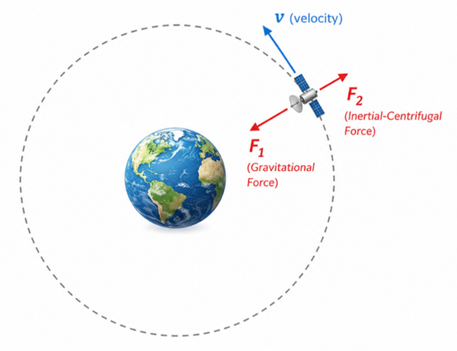
Two forces act on an orbiting satellite: Gravitational force (pulling it inward, toward Earth) and Centrifugal force (an apparent outward force due to the satellite’s inertia). The satellite stays stable when these two balance perfectly.
- Too slow → gravity wins → satellite falls back to Earth
- Too fast → centrifugal force wins → satellite escapes into space
- Just right → the satellite keeps orbiting in a stable path
💡 Think of swinging a ball on a string around your head. The string provides the inward tension (like gravity). Your hand at the centre is like Earth. If you swing too slowly, the ball drops; too fast, the string snaps. The ‘just right’ speed maintains the circular path. This is exactly what happens with satellites.
Types of Orbits Based on Altitude
Orbital altitude is the most fundamental classification. Based on how high above Earth a satellite orbits, we have three main categories — LEO, MEO, and HEO. Think of them as three ‘floors’ of space.
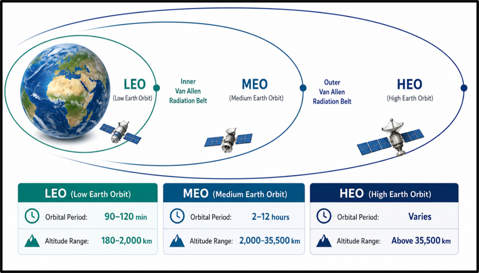
| Orbit Type | Altitude Range | Orbital Period | Key Uses | Examples (Indian + Global) |
| LEO | 180 – 2,000 km | 90 – 120 min | Earth observation, remote sensing, communication, ISS | Cartosat, RISAT, EOS-04, Starlink, ISS |
| MEO | 2,000 – 35,500 km | 2 – 12 hours | Navigation (GPS/GNSS), some communication | NavIC, GPS, GLONASS, Galileo, BeiDou |
| HEO | Above 35,500 km | Varies | Deep-space observation, solar monitoring, probes | Aditya-L1, James Webb Telescope, Chandra |
Low Earth Orbit (LEO) — The Workhorse of Space
LEO is the ‘ground floor’ of space, ranging from 160 km to 2,000 km above Earth. Satellites here zoom at ~7.8 km/s, completing one orbit in just 90–120 minutes. Because they are so close to Earth, LEO satellites give us the sharpest images and quickest signals.
Advantages of LEO
- High-resolution imaging: Proximity to Earth means satellites like Cartosat can capture sub-metre resolution images for mapping, military surveillance, and urban planning.
- Lower latency: Signals travel less distance → faster communication. This is why Starlink (SpaceX) uses LEO for internet — no noticeable delay unlike GEO satellites.
- Cost-effective launches: Less fuel needed to reach LEO. Small satellites (CubeSats) regularly launched from here.
- Easier maintenance: The International Space Station (ISS) is in LEO because astronauts can be sent there for repairs and resupply.
- Frequent Earth revisits: Suitable for weather monitoring and surveillance missions.
Disadvantages of LEO
- Orbital decay: Residual atmosphere causes drag, gradually lowering the orbit. ISS needs periodic ‘reboosts’ to maintain altitude.
- Small coverage area: One LEO satellite covers only a small portion of Earth, so constellations (like Starlink’s 5,000+ satellites) are needed for global coverage.
- Space debris risk: LEO is increasingly congested with old satellites and debris, posing collision risks — the ‘Kessler Syndrome’ fear.
Medium Earth Orbit (MEO) — The Navigator’s Home
MEO occupies the middle ground: 2,000 km to 35,500 km. Satellites here take 2 to 12 hours per orbit. The most famous residents of MEO are the navigation satellite constellations — GPS, GLONASS, Galileo, BeiDou, and India’s own NavIC.
- Wider coverage area: Each MEO satellite covers a much larger portion of Earth than LEO, making fewer satellites necessary for global navigation.
- Radiation challenge: MEO passes through the Van Allen Radiation Belts — zones of high-energy particles from solar wind — which can damage satellite electronics. Extra shielding is required.
- Lower latency than GEO: MEO signals have less delay than signals from geostationary satellites, which is crucial for accurate GPS positioning.
High Earth Orbit (HEO) — The Deep Space Observer
HEO lies above 35,500 km. Satellites here move slowly (~3 km/s) and have enormous fields of view. This is the realm of deep-space telescopes, solar observatories, and planetary probes.
- James Webb Space Telescope (JWST): Orbits the L2 Lagrange Point (~1.5 million km away!) — technically in HEO territory.
- Aditya-L1 (ISRO): India’s first solar mission, orbits the L1 Lagrange Point to study the Sun continuously.
- Chandra X-ray Observatory: Deep-space HEO to observe X-rays from distant cosmic objects without atmospheric interference.
⚠ Aditya-L1 is at the Sun-Earth L1 Lagrange Point (not in a simple HEO), allowing uninterrupted observation of the Sun without solar eclipse. Launched by ISRO in September 2023.
Types of Orbits Based on Shape (Eccentricity)
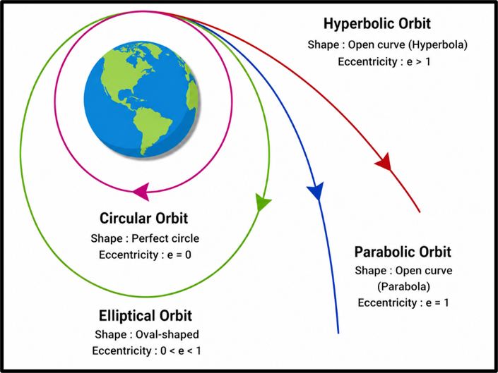
The shape of an orbit is described by eccentricity (e) — a number that tells us how ‘circular’ or ‘stretched’ the orbit is. This gives rise to four distinct shapes:
| Orbit Type | Shape | Eccentricity (e) | Description | Examples |
| Circular | Perfect circle | e = 0 | Constant altitude, constant speed — simple and stable | GPS, INSAT, NavIC |
| Elliptical | Oval/stretched | 0 < e < 1 | Speed and altitude vary — faster at perigee, slower at apogee | Molniya, Tundra, GTO |
| Parabolic | Open curve (parabola) | e = 1 | Object has just enough energy to escape — will not return | Comet Hale-Bopp (near-parabolic) |
| Hyperbolic | Open curve (hyperbola) | e > 1 | Object exceeds escape velocity — permanently escapes | Voyager 1 & 2, Oumuamua |
Circular Orbit — Simplicity at its Best
A circular orbit maintains constant altitude and constant speed throughout — like a toy train running on a perfectly round track.
- Eccentricity = 0
- Constant speed: Gravitational force equals centripetal force at all points.
- Predictable: Easiest to calculate, most stable, most fuel-efficient to maintain.
- Used for: GPS satellites (MEO), INSAT (GEO), Hubble Space Telescope (LEO).
Elliptical Orbit — Flexible and Versatile
An elliptical orbit is the natural shape of all gravitationally bound orbits (Kepler’s 1st Law). The satellite alternates between perigee (closest, fastest) and apogee (farthest, slowest).
- Highly Elliptical Orbit (HEO): Very stretched — dramatically different perigee and apogee. Molniya and Tundra orbits are examples designed for polar coverage.
- Transfer orbits: Elliptical orbits are used as ‘highways’ to shift satellites from one circular orbit to another. Geostationary Transfer Orbit (GTO) is the most common example.
- Flexibility: Can be designed to linger over specific regions for extended periods.
💡 Think of an elliptical orbit as a comet’s path around the Sun. It rushes through the inner solar system at high speed (near perihelion) and then drifts slowly in the outer reaches (near aphelion). Halley’s Comet, for instance, has a highly elliptical orbit that brings it near Earth every 75-76 years.
Parabolic Orbit — The Edge of Escape
A parabolic orbit represents the critical threshold — the object has exactly enough energy to escape gravity but will not return. Eccentricity = 1 exactly.
- Velocity = escape velocity (exactly)
- Theoretical concept — used to calculate minimum escape energy in spacecraft trajectory planning
- Near-parabolic comets like Comet Hale-Bopp and Comet Hyakutake follow paths very close to e = 1
Hyperbolic Orbit — One-Way Ticket to the Stars
When an object moves faster than escape velocity, it follows a hyperbolic path and escapes the gravitational system permanently. Eccentricity > 1.
- Voyager 1 & 2: Both spacecraft are now in hyperbolic trajectories beyond the Solar System — humanity’s first interstellar objects.
- Oumuamua: First detected interstellar visitor (2017) — had a hyperbolic trajectory, confirming it came from outside our solar system.
- Gravity assist / Slingshot: Hyperbolic trajectories are used for gravity-assist manoeuvres — flying close to a planet to ‘steal’ some of its orbital energy.
⚠ The Slingshot Effect (Gravity Assist) is an important topic. Voyager missions used Jupiter, Saturn, Uranus, and Neptune for sequential gravity assists. India’s Mangalyaan used an Earth gravity assist to reach Mars.
Types of Orbits Based on Inclination
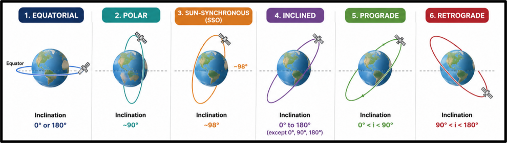
Orbital inclination is the angle between the satellite’s orbital plane and Earth’s equatorial plane. It determines which latitudes the satellite covers. This is one of the most important parameters — especially regarding remote sensing and navigation satellites.
| Orbit Type | Inclination | Direction | Key Use | Examples |
| Equatorial | 0° or 180° | Along equator | GEO communication, weather | INSAT, GSAT, GOES |
| Polar | ~90° | Over poles | Earth observation, surveillance | IRS, NOAA, Cartosat |
| Sun-Synchronous (SSO) | ~98° | Slightly retrograde | Remote sensing (same sunlight daily) | Cartosat, Sentinel, Landsat |
| Inclined | 0° to 180° (except 0°, 90°, 180°) | Diagonal | Regional coverage | NavIC, some military |
| Prograde | 0° < i < 90° | West to East | Communication, navigation | ISS, Starlink, GPS |
| Retrograde | 90° < i < 180° | East to West | Military, ASAT | Keyhole spy satellites |
Equatorial Orbit — Hugging the Equator
Imagine drawing a circle around Earth’s waist — that is an equatorial orbit. The satellite travels directly above the equator at 0° inclination. Geostationary satellites (GEO) are a special type of equatorial orbit.
- Advantage: Stable, predictable, lower energy for maintenance, ideal for TV broadcasting and telecommunications.
- Disadvantage: Cannot see polar regions. GEO satellites have dead zones at latitudes above ~75°N or S.
Polar Orbit — The Global Scanner
Polar orbits fly over the Earth’s north and south poles at ~90° inclination. As Earth rotates below, the satellite scans different longitude strips each orbit — eventually covering the entire globe. This makes polar orbits ideal for comprehensive Earth observation.
- Altitude: Typically 500–1,500 km (LEO)
- Speed: ~7.8 km/s, period ~90-120 minutes
- Uses: Mapping (Cartosat), weather (NOAA, MetOp), surveillance (RISAT, Keyhole series), scientific research
- Limitation: Not suitable for continuous communication over a single region; high radiation exposure at poles
Sun-Synchronous Orbit (SSO) — Nature’s Photographer
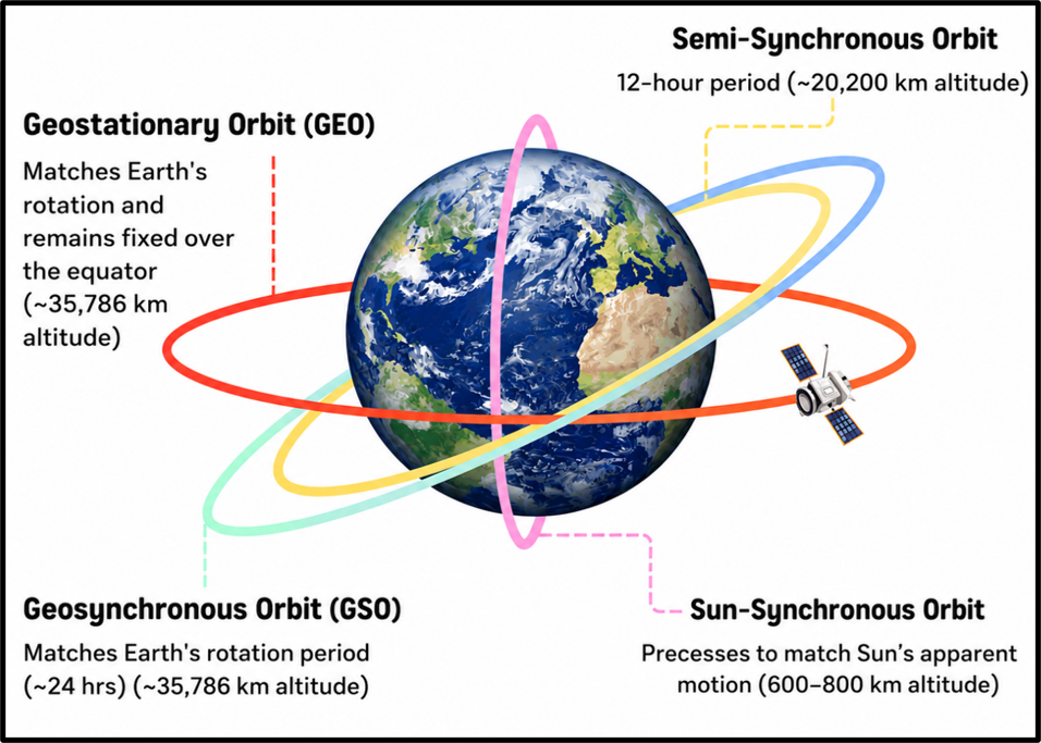
SSO is the smartest of all polar orbits. A satellite in SSO passes over the same location at the same local solar time every day — ensuring identical lighting conditions for photography and remote sensing. Inclination ~98° (slightly retrograde).
💡 Imagine taking a photograph of your garden every day, always at 10:30 AM. The shadows are always in the same direction, the lighting is always the same. Now imagine doing that for the entire planet! That is what SSO satellites do — they are the ‘consistent photographers’ of Earth. This is how we compare forest cover, glacier retreat, or urban expansion reliably over years.
- How it works: Earth’s equatorial bulge (it’s slightly flattened at poles) causes the orbital plane to precess ~1°/day — exactly matching Earth’s revolution around the Sun (~1°/day). So the angle to the Sun remains constant.
- Uses: Cartosat, Landsat, Sentinel-2, SCATSAT, KH-11 (spy).
- Key numbers: Altitude 600–800 km, inclination ~98°, period ~90-120 min.
⚠ Key distinction: SSO is not strictly polar (90°) but slightly retrograde (~98°). Its orbital plane precesses in sync with Earth’s orbit around the Sun.
Prograde and Retrograde Orbits
- Prograde (Direct) Orbit: Satellite moves in the SAME direction as Earth’s rotation (west to east). Inclination 0° to 90°. Most satellites use prograde orbits because launches can take advantage of Earth’s rotational velocity — a free speed boost!
- Retrograde Orbit: Satellite moves AGAINST Earth’s rotation (east to west). Inclination 90° to 180°. Requires more fuel (cannot use Earth’s rotation assist). Used for military/spy satellites, ASAT missions, and some special scientific missions.
Types of Orbits Based on Synchronicity
‘Synchronicity’ asks: how does the satellite’s orbital period relate to Earth’s rotation or the Sun’s apparent motion? This gives us four important orbits:
Geosynchronous Orbit (GSO) vs. Geostationary Orbit (GEO)
These two are often confused. Let us settle this once and for all. Both have an orbital period of ~24 hours — matching Earth’s rotation. But the key difference lies in the inclination and shape of the orbit.
| Feature | Geosynchronous Orbit (GSO) | Geostationary Orbit (GEO) |
| Orbital Period | 24 hours (matches Earth’s rotation) | 24 hours (matches Earth’s rotation) |
| Altitude | ~35,786 km | ~35,786 km |
| Inclination | Can be inclined (not 0°) | EXACTLY 0° — directly above equator |
| Ground Track | Moves in a figure-eight pattern | Appears completely stationary |
| Orbital Shape | Circular or elliptical | Always circular |
| Polar Coverage | Limited to moderate | Very poor to none |
| Ground Station | Requires tracking antennas | Fixed antennas — no tracking needed |
| Examples | NavIC (some), QZSS (Japan) | INSAT, GSAT, GOES, Meteosat |
💡 A simple way to remember: GEO is a SPECIAL CASE of GSO. All GEO satellites are geosynchronous, but not all geosynchronous satellites are geostationary. GEO is GSO with three additional constraints: circular orbit, 0° inclination, equatorial plane.
Why do GEO satellites appear stationary? Three simultaneous conditions are met:
(1) The orbital period is exactly 23h 56m 4s (sidereal day).
(2) The orbit is circular (eccentricity = 0).
(3) Inclination is exactly 0° (above equator).
The satellite orbits west-to-east matching Earth’s spin — so from Earth, it appears to hang in one fixed spot.
Sun-Synchronous Orbit (SSO)
Already covered above
Semi-Synchronous Orbit — The GPS Orbit
A semi-synchronous orbit has an orbital period of ~12 hours — meaning the satellite completes two full orbits per day. It operates at ~20,200 km altitude (MEO). This is the orbit of all major navigation satellite constellations.
- GPS (USA): 24 satellites at ~20,200 km, 55° inclination, 12-hour period
- GLONASS (Russia): MEO, ~19,100 km, 64.8° inclination
- Galileo (EU): MEO, ~23,222 km
- BeiDou (China): Mix of MEO, GEO, and IGSO satellites
- NavIC (India): Mix of GEO and Geosynchronous satellites — primarily GSO, NOT semi-synchronous
⚠ NavIC / IRNSS is India’s regional navigation system. It uses 7 satellites — 3 in GEO and 4 in inclined geosynchronous orbit (~GSO at 29° inclination). It covers India and a 1,500 km region around it. NavIC is NOT in MEO semi-synchronous orbit like GPS.
Transfer Orbits — Highways of Space
A transfer orbit is a temporary, intermediate orbit used to move a spacecraft from one orbit to another — usually from a lower orbit to a higher one. Think of it as changing lanes on a cosmic highway.
Hohmann Transfer Orbit (HTO) — The Fuel-Saver
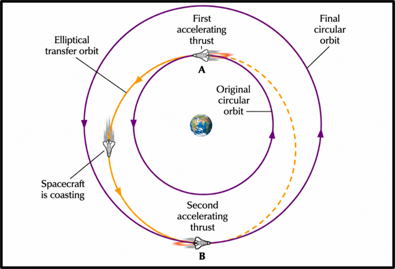
The Hohmann Transfer Orbit is the most elegant and fuel-efficient method for moving between two circular orbits in the same plane. Developed by Walter Hohmann in 1925, it involves just two engine burns.
How it works (Step by Step):
- Burn 1: The spacecraft fires its engine at the starting circular orbit to enter the elliptical transfer orbit
- Coast: The spacecraft coasts along the transfer ellipse (no fuel used)
- Burn 2: At the destination altitude (apogee of the transfer ellipse), fire again to circularise into the target orbit
- Example — Mangalyaan (Mars Orbiter Mission): ISRO used a Hohmann-like transfer to send Mangalyaan from Earth’s orbit to Mars in 2013. With a small budget (Rs. 450 crore — less than the movie Gravity!), ISRO demonstrated perfect orbital mechanics.
- Limitation: Only works for coplanar orbits (no inclination change). Slow — takes half an orbital period. Not fuel-efficient for very large orbit changes.
Bi-Elliptic Transfer Orbit — The Long Route Paradox
When the target orbit is much larger than the initial orbit (more than ~11.94× larger), the bi-elliptic transfer becomes more fuel-efficient than Hohmann, despite taking a longer route.
- First burn: enters a highly elliptical orbit
- Second burn: at the far apoapsis, adjusts energy
- Third burn: circularises at target altitude
Used for: Moving satellites from LEO to very high MEO/GEO when fuel efficiency matters more than time.
Geostationary Transfer Orbit (GTO) — India’s Standard Route
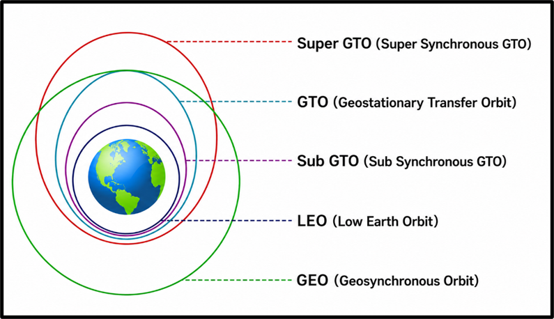
GTO is a highly elliptical orbit that bridges LEO and GEO. The rocket launches the satellite into GTO (with perigee in LEO and apogee at GEO altitude). The satellite’s own engine then fires at apogee to circularise into GEO.
- Used by: GSAT satellites, INSAT series, most commercial GEO communications satellites
- Why not go directly to GEO? The rocket needs enormous fuel to reach GEO directly. GTO is a compromise — the rocket does the heavy lifting to GTO, and the smaller onboard Apogee Kick Motor (AKM) handles the final circularisation.
- Duration: 6–12 hours orbital period in GTO
- Chandrayaan-1 connection: Used an extended GTO variant before trans-lunar injection
⚠ Know: perigee = LEO altitude, apogee = GEO altitude (~35,786 km). The Apogee Kick Motor (AKM) fires at apogee for final GEO insertion.
Low-Thrust Transfer Orbit — The Patient Traveller
Instead of powerful short burns, low-thrust propulsion uses continuous gentle thrust over months or years. Ion thrusters and Hall-effect thrusters are the engines of choice.
- Fuel efficiency: Ion propulsion uses 10× less propellant than chemical rockets for the same velocity change
- Used in: Dawn mission (asteroid belt), BepiColombo (Mercury), Starlink orbit-raising
- Disadvantage: Extremely slow — takes months to reach target orbit. Cannot be used for emergency manoeuvres.
Gravity-Assist Transfer Orbit — The Slingshot Effect
The gravity assist manoeuvre is one of the most brilliant techniques in spaceflight. By flying a spacecraft close to a planet, the planet’s gravity bends the spacecraft’s trajectory and transfers orbital energy from the planet to the spacecraft — for FREE.
💡Imagine a ping-pong ball rolling toward a spinning merry-go-round. If it passes close to the edge at the right angle, it gets flung away faster than it arrived. The merry-go-round loses a tiny bit of its spinning energy — imperceptible, since the planet is so massive — but the ping-pong ball (spacecraft) gains enormous velocity. Nature provides a free fuel boost!
- Voyager 2: Used gravity assists from Jupiter, Saturn, Uranus, AND Neptune in sequence — a once-in-175-year alignment. Now flying beyond the solar system.
- Parker Solar Probe: Used Venus flybys to SLOW DOWN and spiral closer to the Sun — reverse gravity assist!
- ISRO’s Mangalyaan: Used Earth’s gravity for slingshot to set the trajectory toward Mars
| Transfer Orbit | Burns | Efficiency | Best Use Case | Indian Connection |
| Hohmann (HTO) | 2 | Very fuel-efficient for small-medium orbit change | LEO to GEO, planetary missions | Mangalyaan (Mars mission) |
| Bi-Elliptic (BETO) | 3 | Better than Hohmann for large orbit changes | LEO to deep-space orbits | Theoretical; rarely used |
| Geostationary Transfer (GTO) | 2 | Moderate | Putting communication sats in GEO | GSAT, INSAT satellites |
| Low-Thrust | Continuous | Extreme fuel efficiency | Deep-space, ion-propelled | Future ISRO missions |
| Gravity Assist | 0 during flyby | Free energy gain | Interplanetary missions | Mangalyaan used Earth slingshot |
Lagrange Points and Halo Orbits
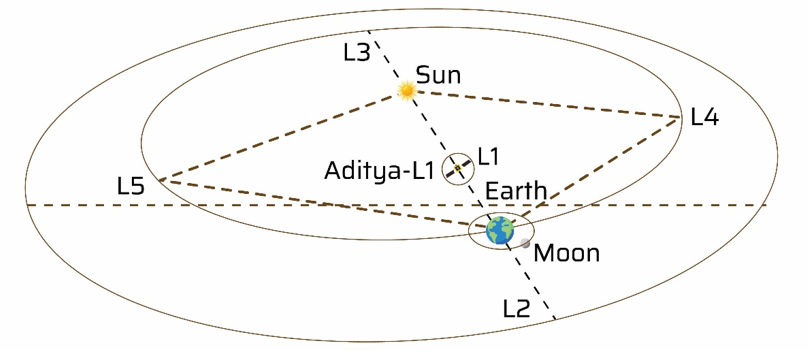
Picture a cosmic game of tug-of-war: the Sun pulls on one side, Earth pulls on the other. Now imagine finding a point in space where these two tugs perfectly balance — so that a small satellite placed there feels no net gravitational pull in one direction. These are the Lagrange Points, discovered mathematically by Joseph-Louis Lagrange in 1772.
For any two massive bodies (Sun-Earth, Earth-Moon), there are exactly five such balance points, labeled L1 to L5.
| Point | Location | Stability | Why It Matters | Real Mission |
| L1 | BETWEEN Sun and Earth (~1.5 million km from Earth) | Unstable | Best view of the Sun — no eclipse possible | Aditya-L1 (ISRO), SOHO (NASA/ESA), DSCOVR |
| L2 | BEYOND Earth, away from Sun (~1.5 million km from Earth) | Unstable | Cold, dark side — no Sun interference — ideal for infrared telescopes | James Webb Space Telescope (JWST), Gaia |
| L3 | Opposite side of Sun from Earth | Unstable | Permanently hidden behind the Sun — no practical use | Hypothetical; no missions |
| L4 | 60° AHEAD of Earth in its orbit | Stable | Trojan asteroids gather here — natural gravitational trap | Trojan asteroids (Earth/Jupiter) |
| L5 | 60° BEHIND Earth in its orbit | Stable | Future space colonies? Long-term stable position | Future NASA/ESA concepts |
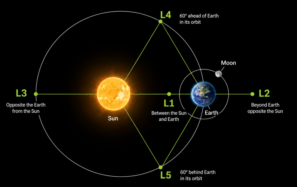
💡 The difference between stable (L4, L5) and unstable (L1, L2, L3) Lagrange points is like the difference between the bottom of a valley vs. the top of a hill. Place a ball at the bottom of a valley (L4/L5) — it rolls back if nudged. Place it at the top of a hill (L1/L2/L3) — it rolls away. Unstable points require small periodic thruster corrections to maintain position.
Halo Orbit
Because L1 and L2 are unstable (no gravity to hold satellites there), spacecraft use a special technique: they orbit around the Lagrange point in a Halo Orbit. By using minimal thruster corrections, the spacecraft loops around the otherwise empty L1/L2 point — like orbiting a ghost.
- Aditya-L1: In a halo orbit around the Sun-Earth L1 point. Studies solar wind, corona, and solar flares 24/7.
- JWST: In a halo orbit around the Sun-Earth L2 point. At -233°C, it studies early universe infrared signals.
- SOHO: NASA/ESA solar observatory in a halo orbit at L1 since 1995.
Other Special Orbits
Beyond the main categories, several specially designed orbits serve unique strategic or scientific purposes. Here are the most important ones:
Molniya Orbit — Russia’s Polar Solution
Russia had a problem: GEO satellites cannot adequately cover high northern latitudes (Siberia, Arctic regions). So Soviet engineers invented the Molniya Orbit — a Highly Elliptical Orbit (HEO) that spends most of its 12-hour period lingering over the high northern latitudes.
- Inclination: 63.4° (critical — avoids orbital precession issues at this specific angle)
- Eccentricity: ~0.7 (very elliptical)
- Period: 12 hours (semi-synchronous)
- Used by: Russian military and communication satellites; also Sirius XM satellite radio
💡The 63.4° inclination is not arbitrary — it is the ‘magic angle’ at which Earth’s equatorial bulge does NOT cause the orbit’s perigee point to precess (rotate). Without this, the apogee would drift away from the high-latitude zone over time. Russian engineers were clever to discover this mathematical sweet spot.
Tundra Orbit — Molniya’s Cousin
Similar in concept to Molniya but with a 24-hour period (geosynchronous). It is highly elliptical (eccentricity 0.2–0.3) and highly inclined (63.4°), providing continuous long-duration coverage of high-latitude regions — unlike Molniya which needs multiple satellites for continuity.
- Used for: High-latitude communications, especially Northern Hemisphere coverage
Parking Orbit — The Holding Pattern
A parking orbit is a temporary orbit where a spacecraft waits before performing a major manoeuvre — such as waiting for planets to align for an interplanetary injection, or waiting for a docking port to become available on the ISS.
- Example: A rocket launches into LEO parking orbit, then fires for trans-lunar injection (to the Moon)
- Chandrayaan and Mangalyaan both used parking orbits before their final departure burns
Graveyard Orbit — The Satellite Cemetery
When a satellite’s operational life ends, it needs to be disposed of responsibly. A graveyard orbit (also called a disposal orbit or junk orbit) is a high-altitude orbit (~36,000 km — slightly above GEO) where decommissioned satellites are permanently relocated.
- Prevents the GEO belt from being cluttered with dead satellites
- Avoids space debris and the Kessler Syndrome (catastrophic collision cascade)
- Required by international space law guidelines (COPUOS / UN framework)
⚠ Remember: LEO dead satellites are deorbited to burn up in atmosphere; GEO dead satellites are moved to graveyard orbit ~300 km above GEO.
Quick Revision
| Orbit | Classification | Altitude / Inclination | Period | Key Feature | Indian Example |
| LEO | By Altitude | 160–2000 km | 90–120 min | High res imaging, low latency | RISAT, EOS-04, Cartosat |
| MEO | By Altitude | 2000–35500 km | 2–12 hrs | Navigation, wider coverage | NavIC satellites (partial) |
| HEO | By Altitude | >35500 km | Varies | Deep-space, solar obs | Aditya-L1 (L1 point) |
| GEO | By Synchronicity | 35786 km / 0° | 24 hrs | Stationary, TV/telecom | INSAT-3D, GSAT-30 |
| GSO | By Synchronicity | 35786 km / inclined | 24 hrs | Figure-8 ground track | NavIC GSO sats |
| SSO | By Inclination | 600–800 km / ~98° | 90–120 min | Same solar time daily | Cartosat, SCATSAT |
| Semi-Sync | By Synchronicity | ~20200 km | 12 hrs | GPS-type navigation | (GPS, Galileo orbit type) |
| Polar | By Inclination | 500–1500 km / ~90° | ~100 min | Full global coverage | IRS series, RISAT |
| Molniya | Special | HEO, 63.4° | 12 hrs | High-latitude coverage | (Russian concept) |
| Tundra | Special | HEO, 63.4° | 24 hrs | Continuous high-lat coverage | (Russian/US concept) |
| GTO | Transfer | Perigee=LEO, Apogee=GEO | 6–12 hrs | Bridge from LEO to GEO | GSAT launches via GSLV |
| Graveyard | Special | >36000 km | N/A | Dead satellite disposal | ISRO disposal practice |