
Border Security
A nation is defined not only by what lies within it, but by the line where it ends and another begins. That line — walked by soldiers in the snows of Siachen, patrolled by a fisherman-turned-informer off the Gujarat coast, and now watched by radar against a plastic drone humming across a Punjab field at night — is where sovereignty is tested every single day.
Conceptual Foundations
Border, Boundary and Frontier — Why the Distinction Matters
In everyday speech we use border, boundary and frontier as if they mean the same thing. In the study of security they do not, and confusing them is the source of many analytical errors. Precision here pays off in every answer you write.
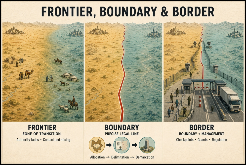
Frontier
A frontier is a zone, not a line. It is a broad, often thinly governed belt of transition lying between two political authorities — a region of contact and mixing where the writ of neither state is complete. Frontiers belong to an older world in which power faded gradually as one moved away from a capital, rather than stopping at a fixed line.
Boundary
A boundary is a precise line that legally separates the sovereign jurisdiction of one state from another. A boundary is manufactured in a definite sequence:
- first allocation (deciding which territory belongs to whom),
- then delimitation (describing the line in a treaty and drawing it on a map),
- and finally, demarcation (physically marking it on the ground with pillars, fences or posts).
Border
A border is the boundary plus the administrative machinery built around it — the outposts, check posts, guarding forces and regulatory systems through which a state actually manages the movement of people and goods across the line. The boundary is the legal fact; the border is the living, managed reality.
Why does this matter for India? A great many of India’s problems arise precisely because a line is a boundary on paper but not demarcated on the ground — the sources of Sir Creek and Kalapani are exactly such disputes.
Others arise because a former frontier zone was hardened into a boundary that cut straight through communities that had lived and traded across it for centuries, as happened along the borders with Myanmar and Bangladesh. Getting the concept right tells you immediately what kind of solution a given dispute needs.
Types of Boundaries and the Idea of Border Management
Boundaries are classified in two useful ways.
- By physical character they are either natural boundaries, which follow a geographical feature such as a river, a mountain watershed or a desert, or artificial boundaries, which are man-made lines — often geometric — with no relation to the terrain.
- By relationship to human settlement, they may be
- antecedent (drawn before an area was settled),
- subsequent (drawn after a community had grown, thereby dividing it),
- superimposed (imposed by an outside power over the wishes of the people), or
- relict (no longer functioning as a political line but still visible in the landscape).
India’s boundaries are overwhelmingly artificial and superimposed — the handiwork of colonial commissions such as the Radcliffe and Bengal Boundary Commissions, drawn in haste with old district maps, cutting across ethnic and kinship ties.
This single fact — that our lines were superimposed on living communities — explains why trans-border social ties, illegal migration and infiltration recur along almost every frontier.
This leads to the most important conceptual distinction in the entire chapter: border guarding versus border management.
- Border guarding is the narrow, force-based task of physically preventing illegal crossing — the wall, the fence, the sentry.
- Border management is the far wider, holistic idea that a border must simultaneously function as a barrier against threats and a bridge for legitimate exchange.
It brings together five things: guarding, regulation of lawful trade and travel, development of the border region, bilateral institutional mechanisms with the neighbour, and increasingly technology and community participation.
A border managed only as a wall breeds resentment among the people who live along it; a border managed as a bridge wins their loyalty and, through them, their eyes and ears.
| Dimension | Border Guarding | Border Management |
| Core idea | Physically stop illegal crossing | Barrier against threats + bridge for legitimate flows |
| Scope | Fencing, patrolling, interception | Guarding + regulation + development + diplomacy + technology |
| Primary actor | Border guarding force alone | Many agencies, ministries, states and local communities |
| Attitude to locals | Population is a problem to be policed | Population is a partner to be developed and engaged |
| Success metric | Fewer crossings | Secure, developed, loyal and integrated border region |
Why India’s Borders Are Uniquely Difficult
Very few countries face a border problem as complex as India’s, and it is worth pausing to see why. Five factors combine.
- Sheer scale and diversity of terrain. India’s land boundary runs across virtually every landscape on earth — the salt marshes of the Rann of Kutch, the Thar desert, the fertile plains of Punjab, the year-round snows of the Himalaya, the shifting riverbeds of Bengal, and the dense tropical jungles of the North-East. No single guarding technique works everywhere.
- Artificial, porous and partly unsettled lines. Because the boundaries were superimposed, long stretches meander through villages, fields and rivers, remain undemarcated, or are actively disputed with the neighbour.
- Trans-border ethnic and kinship ties. Nagas, Kukis and Chins live astride the Myanmar line; Bengali, Nepali and Punjabi communities span their respective borders. These living ties make sealing a border a social as much as a physical challenge.
- A hostile strategic neighbourhood. India is the only major power hemmed in by two nuclear-armed adversaries — Pakistan and China — whose growing coordination raises the spectre of a two-front collusive threat, while the wider periphery is chronically unstable.
- Institutional multiplicity. Several forces guard different borders, and responsibility is split between the Ministry of Home Affairs and the Ministry of Defence, making unified command and accountability difficult.
| CURRENT STATUS (as of August 2026) India shares a land boundary of about 15,106.7 km with seven neighbours — Bangladesh (the longest), China, Pakistan, Nepal, Myanmar, Bhutan and a small notional stretch with Afghanistan through territory it claims but does not control. It also has a coastline of about 7,516.6 km, treated separately in the study of coastal and maritime security. The Department of Border Management in the Ministry of Home Affairs is the nodal authority for most land borders, working on the ‘One Border, One Force’ principle. |
India’s Land Borders — Country by Country
Each of India’s land borders has its own personality — its own terrain, its own history and its own bouquet of threats. Before we walk them one by one, it helps to fix the guarding architecture in mind: the principle of ‘One Border, One Force’ assigns a single specialised force to each frontier so that it is not distracted by other duties and can build deep familiarity with its stretch.
| Border | Approx. length | Guarding force |
| India–Pakistan | 3,323 km | Border Security Force (BSF) |
| India–China (LAC) | 3,488 km | Indo-Tibetan Border Police (ITBP) |
| India–Bangladesh | 4,096.7 km | Border Security Force (BSF) |
| India–Nepal | 1,751 km | Sashastra Seema Bal (SSB) |
| India–Bhutan | 699 km | Sashastra Seema Bal (SSB) |
| India–Myanmar | 1,643 km | Assam Rifles |
A caution before the figures: distances and force allocations along these borders are periodically revised, and older textbooks carry outdated numbers. The lengths above follow the current official position of the Ministry of Home Affairs. Note too that the border-guarding architecture itself is examined in fuller detail separately; here the focus is the character of each frontier.
The India–Pakistan Border
The 3,323 km India–Pakistan boundary is the most militarised and most tension-prone of all India’s frontiers, running from the hot marshes of the Rann of Kutch, through the Thar desert and the plains of Punjab, up into the cold Himalaya. It is understood in three distinct segments.
- Radcliffe Line / International Boundary (about 2,308 km): the settled international border stretching from Gujarat to parts of the Jammu district, drawn by the Radcliffe award of 1947.
- Line of Control (about 776 km): the military control line in Jammu and Kashmir, tracing its origin to the ceasefire line of the 1947–48 war (formalised by the Karachi Agreement of 1949) and re-designated the Line of Control after the 1971 war and the Simla Agreement of 1972.
- Actual Ground Position Line (about 110 km): running from map point NJ 9842 to Indira Col in the north, this line covers the Siachen Glacier, the highest militarised terrain on earth.
Three disputes define this border.
Sir Creek is a 96 km tidal estuary opening into the Arabian Sea that separates Gujarat from Pakistan’s Sindh. Pakistan claims the entire creek up to its eastern bank, relying on a ‘green line’ shown on a 1914 map; India holds that the boundary runs along the mid-channel of the creek, as depicted on a 1925 map, in keeping with the international principle for navigable channels. The stakes are larger than the marsh itself: fixing this boundary would settle the seaward maritime boundary and therefore the limits of the Exclusive Economic Zone and continental shelf, in waters believed rich in fish and hydrocarbons.
Siachen stems from the ambiguity of the 1949 Karachi Agreement, which delineated the ceasefire line only up to NJ 9842 and then vaguely added that it ran ‘thence north to the glaciers.’ Pakistan later reinterpreted this to claim the area up to the Saltoro Ridge. India pre-empted the move in 1984 with Operation Meghdoot, seizing the commanding heights of the Saltoro Ridge. The glacier’s significance is strategic: it sits between Pakistan-occupied territory and China’s Aksai Chin, and its loss would give Pakistan direct connectivity to China and oversight of the Leh–Srinagar axis.
Gilgit-Baltistan, part of the erstwhile princely state of Jammu and Kashmir and therefore claimed by India, was granted provisional provincial status by Pakistan in 2020. India rejected the move outright. The region’s importance lies in the China–Pakistan Economic Corridor, which passes through this disputed territory — a fact that underlies India’s principled objection to the corridor, examined thematically in the treatment of the external dimensions of terrorism.
Threats along this border are the most varied in the country. Cross-border infiltration of trained terrorists, cross-border tunnels dug under the fence in the Jammu sector, drone-borne smuggling of arms and narcotics, Fake Indian Currency Notes, and heroin flowing in from the Golden Crescent all converge here, supported by a flourishing hawala network. The drone threat, in particular, has transformed this border in the last few years and is examined in detail among the cross-border threats below.
Response. A significant calming step was the reaffirmation of the ceasefire understanding in February 2021, when the two Directors General of Military Operations agreed to strictly observe all agreements along the Line of Control, renewing the 2003 ceasefire after a year that had seen record violations. On the ground, India has deployed the Comprehensive Integrated Border Management System, piloted a Smart Fence along a 5.5 km stretch in Jammu and Kashmir, and begun raising dedicated anti-drone units.
| CASE STUDY · The drone and the tunnel — a smarter, cheaper infiltration As physical fencing and surveillance made the Jammu–Punjab border harder to cross on foot, hostile networks adapted in two directions — downward and upward. Downward: cross-border tunnels, some fitted with wooden supports and running several hundred metres, have repeatedly been discovered in the Samba and Kathua sectors, dug to move infiltrators beneath the fence. Upward: cheap, commercially available quadcopters now ferry heroin and small arms across the international border, especially in Punjab, requiring no human to physically cross. The lesson for border management is that a static barrier invites the adversary to go around, under or over it — which is exactly why the response must be a layered, technology-led system rather than a single wall. |
| CURRENT STATUS (as of August 2026) Drone activity on the Punjab frontier has surged: the BSF recorded roughly 107 drone sightings in 2023, rising to about 200 in 2024 — mostly small Chinese-made craft carrying heroin, arms and ammunition, countered by a mix of rifle fire, jamming and intelligence-led recoveries. The February 2021 ceasefire understanding has broadly held along the Line of Control, though it remains fragile and periodically strained by terror incidents. |
The India–China Border
The 3,488 km India–China frontier is not a settled boundary at all but a Line of Actual Control — a line that has never been mutually delimited on maps or demarcated on the ground, which is the root of its instability. It runs along Jammu and Kashmir (Ladakh), Himachal Pradesh, Uttarakhand, Sikkim and Arunachal Pradesh. India and China did not even share a common border until China occupied Tibet in 1950, converting the old India–Tibet line into the India–China line; from 1954 onward Beijing began claiming large tracts on the Indian side.
The dispute is understood in three sectors.
- Western Sector (Aksai Chin): originally part of Jammu and Kashmir, this cold desert has been under Chinese control since the 1962 war — some 38,000 sq km — across which China built a strategic highway linking Tibet and Xinjiang. To this must be added the roughly 5,180 sq km of the Shaksgam Valley ceded to China by Pakistan in 1963 from territory India claims.
- Middle Sector (Himachal Pradesh and Uttarakhand): the least contested stretch, where the two sides broadly agree on the alignment except around the Barahoti plains, and have even exchanged maps.
- Eastern Sector (Sikkim to Arunachal Pradesh): defined by the McMahon Line agreed at the Simla Convention of 1913–14. China rejects the line as a colonial imposition and claims the whole of Arunachal Pradesh — about 90,000 sq km — as ‘South Tibet.’
Since 2017 the border has seen a dangerous run of flashpoints. The Doklam standoff (2017) on the India–Bhutan–China trijunction saw Indian troops block a Chinese road that would have threatened the narrow Siliguri Corridor — the ‘Chicken’s Neck’ linking the North-East to the rest of India. The Galwan Valley clash (June 2020) produced the first combat fatalities on the border in decades and triggered stand-offs at multiple points — Galwan, the Hot Springs area, Pangong Tso, and later Depsang and Demchok.
A turning point came in October 2024. India and China reached an agreement on patrolling arrangements at Depsang and Demchok, the two friction points that had remained unresolved, under which patrolling and, where applicable, grazing would resume as per the longstanding practice that prevailed before the stand-off. Verification patrolling followed, while the buffer zones and earlier disengagement terms at other points continued to apply. It marked the most substantial easing of the four-and-a-half-year crisis, without resolving the underlying question of the undelimited line.
Two further irritants deserve note: a growing border-village strategy on both sides — China has built ‘well-off’ model villages right up to the line, and India has responded with its own programme to revitalise border villages — and a simmering water dispute over Chinese dam-building on the Yarlung Tsangpo, the upper Brahmaputra, which raises fears for downstream flows into the North-East and Bangladesh.
| CASE STUDY · Galwan 2020 and the pivot to infrastructure The Galwan clash did more than cost lives; it ended the assumption that the LAC could be kept quiet by understandings alone. India’s response was a decisive pivot to matching China’s border build-up. The Border Roads Organisation was given greater administrative and financial autonomy to accelerate strategic road and tunnel construction. Bridges such as the Dhola–Sadiya and all-weather axes were prioritised to speed troop mobility. A dedicated programme to develop and repopulate border villages was launched to counter depopulation and assert presence. The episode illustrates a core lesson of border management: infrastructure is itself a form of defence, because it converts a remote, indefensible frontier into one that can be reinforced quickly. |
| CURRENT STATUS (as of August 2026) The October 2024 Depsang–Demchok patrolling agreement has held, and both sides have since taken steps to normalise ties, though full de-escalation and boundary delimitation remain distant. India’s border-village revitalisation effort has been extended in a second phase to villages along all land borders, examined in fuller detail under border infrastructure and development. |
The India–Bangladesh Border
At 4,096.7 km, the border with Bangladesh is India’s longest, touching West Bengal, Assam, Meghalaya, Tripura and Mizoram. It was drawn in 1947 by the Bengal Boundary Commission under Sir Cyril Radcliffe using old district maps, and it shows: instead of following natural features the line meanders through villages, farmland and rivers, is densely populated with cultivation running right up to it, and remains highly porous.
The most celebrated success on this border is the settlement of a decades-old anomaly through the Land Boundary Agreement of 2015. Under it, India and Bangladesh exchanged enclaves — small pockets of one country’s territory marooned inside the other — and resolved adverse possessions. India transferred 111 enclaves to Bangladesh and received 51 Bangladeshi enclaves, giving nearly fifty thousand stateless residents a clear nationality at last. It was given effect by the Constitution (One Hundredth Amendment) Act, 2015.
Threats remain formidable: large-scale illegal migration, cattle smuggling, Fake Indian Currency Notes, human trafficking, and a steady traffic in arms, narcotics and consumer goods (jamdani sarees, sugar, salt, diesel). Insurgents from the North-East have historically used the porous line to slip across for sanctuary. There are also recurring trans-border river disputes over the sharing of the Teesta and other rivers.
Response. Beyond continuous fencing and floodlighting, India has inducted technology-led surveillance, most notably the BOLD-QIT project on the riverine Brahmaputra stretch in Dhubri, and maintains a layered set of institutional mechanisms with the Border Guard Bangladesh, from company-commander meetings up to Director-General-level conferences.
| CASE STUDY · BOLD-QIT — sealing a river you cannot fence The Dhubri stretch of the border in Assam is dominated by the Brahmaputra, which fans out into shifting channels and sandbars where a physical fence is simply impossible. The Border Electronically Dominated QRT Interception Technique (BOLD-QIT), deployed under the Comprehensive Integrated Border Management System, blankets this riverine gap with thermal imagers, sensors, radars and night-vision devices feeding a control room, so that any movement across the water triggers a quick-reaction team. It is the model for how technology fills the gaps that fencing leaves — on rivers, in marshes and over rugged terrain. |
| CURRENT STATUS (as of August 2026) The regime change in Dhaka in August 2024 has strained bilateral ties and, security agencies warn, reopened routes for Fake Indian Currency Notes and renewed concerns over infiltration along the eastern border. Cattle smuggling has fallen from its earlier peak following tighter regulation and BSF action, but arms, narcotics and currency smuggling persist. |
The India–Nepal Border
The 1,751 km border with Nepal is India’s model of an open border — people move across it freely, without passport or visa, under the deep civilisational kinship codified in the Treaty of Peace and Friendship of 1950. It runs along Uttarakhand, Uttar Pradesh, Bihar (which shares the largest stretch), West Bengal and Sikkim. As a landlocked country, Nepal depends on India for its nearest access to the sea.
Openness, however, is a double-edged sword. The very freedom that binds the two peoples is misused by hostile elements: Pakistan’s ISI has long treated Nepal as a transit route to push terrorists and Fake Indian Currency Notes into India; hard-core criminals fleeing Indian agencies slip across; and the border carries smuggling of essential goods, arms, drugs and trafficked persons. There is also anxiety about links between Maoist groups on either side.
Two territorial disputes persist along an otherwise 98%-demarcated line. Kalapani–Limpiyadhura–Lipulekh in Uttarakhand turns on where the River Kali (Mahakali) — fixed as the boundary by the 1816 Treaty of Sugauli — actually originates; Nepal published a new political map in 2020 claiming these areas, while India points to its long-standing administrative and revenue records for Kalapani, which lies at the strategically sensitive India–Nepal–China trijunction. Susta is a similar dispute born of the shifting course of the Gandak.
The India–Bhutan Border
The 699 km border with Bhutan is often called the model border — quiet, cooperative and almost entirely settled. Demarcation, begun in 1961, was completed by 2006, and the line adjoins Assam, Arunachal Pradesh, West Bengal and Sikkim. Like Nepal’s, it is an open border, underpinned by a Treaty of Friendship (originally 1949, renegotiated in 2007) that gives India a deep stake in Bhutan’s security.
Its problems are modest by comparison. In the past, North-East insurgent groups such as ULFA, NDFB and the KLO established camps in Bhutan’s southern jungles and used the open border to slip back after carrying out attacks — until the Royal Bhutan Army flushed them out. Low-level smuggling continues: Chinese-made goods, Bhutanese cannabis, liquor and forest produce come in, while livestock, groceries and fruit go out.
The one point of real strategic weight is the Doklam plateau at the trijunction with China. Territory claimed by both Bhutan and China, Doklam overlooks the Siliguri Corridor, and in 2017 India deployed troops to stop Chinese road-building there — the first time it used its own forces to defend Bhutan’s territorial interest, a vivid demonstration of how a neighbour’s border can become India’s own front line.
The India–Myanmar Border
The 1,643 km border with Myanmar runs through four North-Eastern states — Arunachal Pradesh, Nagaland, Manipur and Mizoram — across rugged, forested and largely unfenced terrain. Its origin lies in the colonial Treaty of Yandaboo of 1826, which drew a line straight through communities such as the Nagas, Kukis and Chins, leaving the same ethnic groups on both sides. The border was formally demarcated in 1967.
For decades the defining feature of this border was the Free Movement Regime, formalised in 2018, which allowed members of border tribes to travel up to 16 km across the line without a visa — a humane recognition of kinship that also, unfortunately, became a channel for insurgents to slip across for training and arms, and for the flow of drugs from the neighbouring Golden Triangle, of which heroin and methamphetamine (yaba) are the mainstays.
A decisive policy shift came in 2024. Citing internal security and the need to preserve the demographic balance of the North-East — pressures sharpened by the civil war in Myanmar after the 2021 military coup and by ethnic violence in Manipur — the Ministry of Home Affairs suspended the Free Movement Regime in February 2024 and announced a decision to fence the entire 1,643 km border, of which only a token stretch had been fenced before. The move is contested in the border states, where many communities value the kinship the regime protected.
Other threats include insurgent sanctuaries across the line, poor physical vigilance, and a post-coup inflow of refugees — Chin and Kuki-Zo people fleeing the conflict — into Mizoram and Manipur. The Assam Rifles guards this border, and there is an active policy debate over whether it should be given a single, undivided border-guarding mandate or be replaced in that role by the Border Security Force.
| CASE STUDY · The Free Movement Regime dilemma — kinship versus security The suspension of the Free Movement Regime captures the central tension of all border management in one decision. The case for suspension: an open 16 km corridor let insurgents train and rearm across the line, fuelled the drug trade from the Golden Triangle, and — amid Myanmar’s civil war — risked altering the demographic balance of sensitive states. The case against: the border was drawn through a single people; the regime merely recognised ties of blood and trade that predate both nations, and fencing it risks alienating the very communities whose cooperation is essential to security. The right answer, most analysts argue, is not a binary but a calibrated one — a regulated, documented, shorter-range movement facility rather than either an open corridor or a hard wall. |
| CURRENT STATUS (as of August 2026) The Free Movement Regime stands suspended (February 2024), and the government has committed to fencing the full India–Myanmar border, though physical progress on the ground is gradual and politically contested in Nagaland, Mizoram and Manipur. Myanmar’s continuing internal conflict keeps refugee inflows and cross-border instability a live concern for India’s Act East posture. |
The India–Afghanistan Border
India’s border with Afghanistan is unlike any other: it is a notional 106 km line through the Wakhan Corridor in Badakhshan, adjoining the Gilgit-Baltistan region of Pakistan-occupied Kashmir. It exists on India’s map because the Constitution treats the whole of the former princely state of Jammu and Kashmir, including the areas under Pakistani control, as Indian territory — so, in India’s legal view, India and Afghanistan are neighbours.
Its significance is therefore chiefly legal and strategic rather than operational. For all practical purposes the Ministry of Home Affairs administers land borders with six countries; the seventh, Afghanistan, is claimed but not controlled, which is why some current tabulations list seven neighbours and older ones list six. The claim matters because it underpins India’s position that Pakistan-occupied Kashmir is Indian territory, sharpening its objection to the China–Pakistan Economic Corridor that runs through it; and it hints at a strategic prize — direct overland access to Afghanistan and Central Asia, bypassing Pakistan, were the region ever to return to Indian control.
Cross-Border Threats
A porous border is not dangerous in itself; it becomes dangerous because of what flows through it. If the previous section mapped the borders, this one examines their payload — the specific threats that border porosity delivers into India’s interior, converting a boundary problem into an internal-security problem. These threats are deeply interlinked: the same routes, financiers and syndicates often move migrants, drugs, weapons and counterfeit currency together.
Illegal Migration
Illegal migration — chiefly across the eastern border from Bangladesh, and of Rohingya fleeing Myanmar via Bangladesh — is the cross-border threat with the deepest political and demographic consequences. A 2014 examination question asked directly how illegal trans-border migration threatens India’s security and what strategies can curb it; it remains a template worth mastering.
The drivers are the classic push and pull factors. On the push side: poverty, religious and political persecution, acute demographic pressure and recurring environmental crises in the sending region. On the pull side: the availability of land and employment, and access to healthcare and education in India. Because the migration is clandestine, its scale is genuinely uncertain — parliamentary statements have cited figures as high as two crore Bangladeshi nationals living illegally in India, though such numbers are contested and hard to verify, while the Rohingya population is officially estimated in the tens of thousands, a portion of them holding UNHCR cards.
The security consequences are what make this a strategic issue and not merely a humanitarian one:
- Demographic change in border districts, altering the social and electoral character of sensitive regions.
- Strain on land, jobs and public services, feeding local resentment and communal friction.
- Vote-bank politics, where illegal migrants are alleged to be regularised for electoral gain, undermining the will to act.
- Overlap with trafficking and radicalisation networks, since the same clandestine routes can be exploited by hostile actors.
The policy response has centred on detection and documentation — the National Register of Citizens exercise in Assam being the most prominent — alongside fencing, deportation (which is diplomatically fraught), and proposals for a work-permit system to regularise labour flows while denying citizenship. The subject is legally and politically charged, intertwined with the citizenship debate, and demands careful, rights-respecting handling.
| EXAMINATION FOCUS A recurring question asks how illegal trans-border migration threatens India’s security, the factors that give it impetus, and the strategies to curb it. A strong answer separates drivers (push–pull), consequences (demographic, economic, political, security) and responses (registration, fencing, deportation, work permits, source-country engagement) — and closes by insisting the response be firm on security yet humane and lawful. |
Smuggling — Narcotics, Arms, Gold, Cattle, Wildlife and Counterfeit Goods
India’s geography places it in one of the world’s most unfortunate positions for the drug trade — squeezed between the Golden Crescent (Afghanistan–Pakistan–Iran) on its west and the Golden Triangle (Myanmar–Laos–Thailand) on its east, the two largest illicit opium-producing regions on earth. Smuggling flows accordingly:
- Narcotics: heroin from the Golden Crescent enters through Punjab, Jammu and the Gujarat coast; heroin and methamphetamine (yaba) from the Golden Triangle enter through the North-East. Drones have become a favoured delivery method on the western border. Crucially, drug money finances militancy — the narco-terror nexus examined thematically in the treatment of terror financing.
- Arms and ammunition: small arms, pistols and rounds are pushed across, increasingly by drone in Punjab and through insurgent channels in the North-East, arming both terror modules and organised crime.
- Gold: smuggled by sea and air to evade duty, a purely economic crime that nonetheless launders large sums and sustains hawala networks.
- Cattle: long a signature of the Bangladesh border, driven from northern states to be pushed across; the trade has declined with tighter regulation but has not ended.
- Wildlife: red sanders smuggled out, and rhino horn, pangolin scales and other contraband moved through the eastern and northern borders, feeding transnational syndicates.
- Counterfeit consumer goods and essentials: from fake branded products to sugar, salt, diesel and textiles, moving in whichever direction the price gap rewards.
| Border | Signature smuggling flows |
| Pakistan (west) | Heroin (Golden Crescent), small arms, Fake Indian Currency Notes — increasingly drone-delivered |
| Bangladesh (east) | Cattle, arms, narcotics, counterfeit currency, textiles, essential goods |
| Myanmar (north-east) | Heroin and methamphetamine (Golden Triangle), arms, jade and consumer goods; Red Sanders outbound |
| Nepal (open) | Fake currency, gold, narcotics and essentials exploiting the visa-free border |
| Bhutan (open) | Chinese goods, cannabis, liquor and forest produce in; livestock and groceries out |
Fake Indian Currency Notes — the State-Sponsored Dimension
Of all cross-border threats, Fake Indian Currency Notes are the most explicitly an act of economic warfare — a low-cost, high-impact instrument in Pakistan’s declared strategy of ‘bleeding India by a thousand cuts.’ What distinguishes this threat is its state-sponsored character: security agencies have traced high-quality counterfeit notes to presses in Pakistan, from where they are routed into India through third countries — Nepal, Bangladesh and the Gulf — precisely to disguise their origin.
The damage is twofold. Counterfeit currency erodes confidence in the currency and injects unaccounted money into the economy, and the profits finance terrorism directly. Demonetisation in 2016 dented the existing stock of high-value fakes, but syndicates adapted to replicate the new notes, and the flow resumed. The eastern route is especially sensitive: agencies warn that the 2024 political change in Bangladesh has reopened long-standing FICN corridors.
The institutional response is coordinated through the Fake Indian Currency Notes Coordination Centre (FCORD) in the Ministry of Home Affairs and a dedicated Terror Funding and Fake Currency Cell in the National Investigation Agency, backed by tightened security features in the currency itself and closer intelligence-sharing with source and transit countries.
Human Trafficking Across Land Borders
The same open and porous borders that carry migrants and contraband also carry people who are trafficked — overwhelmingly women and children, moved for sexual exploitation, bonded and domestic labour, and forced marriage. The Nepal and Bangladesh borders are the principal corridors, their openness and poverty on the sending side combining with demand on the Indian side to sustain the trade. Trafficking routes frequently overlap with those used for smuggling and illegal migration, run by the same criminal networks.
The response combines guarding, policing and law. Border-guarding forces such as the SSB and BSF run anti-human-trafficking units and rescue operations at the border, coordinating with civil-society organisations that rehabilitate survivors; investigation and prosecution proceed under the Immoral Traffic (Prevention) Act and the trafficking provisions of the criminal law, supported by dedicated Anti-Human Trafficking Units in the districts. Because trafficking is driven by demand and poverty as much as by porous borders, an effective strategy must pair interdiction with source-side livelihood and awareness efforts.
Unmanned Aerial Vehicles — the Threat Profile and Counter-UAS Response
The rise of the small drone is the single most important new development in border security, and it was the subject of a 2023 examination question that asked squarely about adversaries using unmanned aerial vehicles to ferry arms, ammunition and drugs across the border, and the measures being taken to counter the threat.
The threat profile has three faces. First and most common is logistics: cheap, commercially available Chinese quadcopters ferry heroin, pistols and ammunition across the Punjab and Jammu borders, needing no human being to physically cross a fenced, watched line. Second is weaponisation and attack, demonstrated when explosives-laden drones struck the Jammu Air Force station in June 2021 — the first drone terror attack on Indian soil. Third is surveillance, with drones used to map security installations and troop movements; looming over all three is the future risk of coordinated swarms that could overwhelm defences.
The counter-unmanned-aircraft-system (counter-UAS) response is built in layers:
- Detection through radar, radio-frequency scanners and electro-optical/infrared sensors that spot and track incoming drones.
- Soft-kill measures — jamming the control link or spoofing the navigation signal to force the drone down or send it off course.
- Hard-kill measures — from rifle fire by alert sentries to indigenous directed and gun-based systems, including the DRDO-developed anti-drone platform, now being inducted along the western border.
- Raising dedicated anti-drone units, and — on the regulatory side — the Drone Rules, 2021 with their colour-coded airspace maps that govern legitimate civilian drone use, examined further in the treatment of airspace security.
| CASE STUDY · The Jammu airbase drone attack, June 2021 In the early hours of 27 June 2021, two drones dropped explosive payloads on the Indian Air Force station at Jammu, damaging a building and injuring personnel. It was the first instance of a drone being used to attack a defence installation in India, and it changed the threat calculus overnight: the danger was no longer only smuggling but precision attack from the air by a device costing a few thousand rupees. The attack accelerated India’s counter-drone programme — dedicated units, indigenous detection-and-neutralisation systems, and a search for scalable anti-swarm defences. |
| CURRENT STATUS (as of August 2026) Drone incursions on the western border continue at high volume — of the order of 200 sightings in 2024 on the Punjab frontier alone — driving rapid induction of counter-drone systems and dedicated units. |
Tunnels and the Technology of Tunnel Detection
If the drone is the newest infiltration method, the cross-border tunnel is among the oldest and most stubborn. In the Jammu region — the Samba, Kathua and Hiranagar sectors — hostile handlers have repeatedly dug tunnels beneath the fence and the international boundary, some reinforced with wooden supports and several hundred metres long, to move infiltrators underground past all surface surveillance.
The detection challenge is severe: there is as yet no cheap, reliable technology to spot a tunnel across hundreds of kilometres of border. India is therefore working with a combination of tools — seismic and acoustic sensors that pick up digging vibrations, ground-penetrating radar, and satellite and geospatial analysis of tell-tale surface disturbance and spoil heaps — inducted progressively under the Comprehensive Integrated Border Management System, alongside periodic anti-tunnelling searches by the guarding force. The tunnel threat is the clearest reminder that a border is three-dimensional: it must be secured not only across its face but above it and beneath it.
Border Guarding Architecture
Having walked the borders and catalogued the threats they carry, we now turn to the machinery that guards them — who stands on the line, under whose command, and how the layers behind the line fit together. India’s border-guarding architecture is not the product of a single blueprint; it grew force by force, war by war, and its untidy joints are themselves an important part of the story.
The Principle of ‘One Border, One Force’ and Its Exceptions
The organising idea of India’s land-border guarding is the principle of ‘One Border, One Force’ — that a single specialised force should be responsible for a single border. Its logic is threefold: it fixes single-point accountability so that no lapse can be passed between agencies; it lets a force develop deep familiarity with the terrain, people and threats of its stretch; and it prevents the confusion that arises when several forces jostle on the same line. The principle was not always followed — it was crystallised only after the Kargil conflict, in the recommendations examined in the treatment of committees below — and it is honoured as much in its exceptions as in its observance.
| Border / domain | Guarding force | Controlling ministry |
| Pakistan & Bangladesh (International Boundary) | Border Security Force (BSF) | Home Affairs |
| China (Line of Actual Control) | Indo-Tibetan Border Police (ITBP) | Home Affairs |
| Nepal & Bhutan (open borders) | Sashastra Seema Bal (SSB) | Home Affairs |
| Myanmar | Assam Rifles | Home Affairs (admin) / Defence (operational) |
| Line of Control & AGPL (J&K) | Indian Army (BSF under Army control) | Defence |
| Coastline & territorial waters | Indian Coast Guard | Defence |
Notice at once that the neat principle frays at several points. The Line of Control and the Actual Ground Position Line are held not by the BSF but by the Indian Army, with BSF battalions placed under Army operational control — so the Pakistan front alone is split between two forces and two ministries. The Assam Rifles presents the sharpest anomaly of dual control: it is administered by the Ministry of Home Affairs but operationally commanded by the Army under the Ministry of Defence, and it performs counter-insurgency alongside border guarding rather than pure guarding — which is why a live policy debate asks whether it should be given a single guarding mandate or replaced in that role by the BSF. Even where one force nominally holds a border, guarding forces are frequently pulled away for election and internal-security duty, diluting the very principle they embody.
Force-wise Deployment — BSF, ITBP, SSB and Assam Rifles
Each border-guarding force carries the imprint of the crisis that created it, and knowing that origin makes its role easy to remember.
- Border Security Force, raised in 1965 after that year’s war with Pakistan, is India’s largest border-guarding force and is called the country’s ‘First Line of Defence’. It holds the international boundaries with both Pakistan and Bangladesh, and fields specialised water and air wings and its own artillery for its riverine and desert stretches.
- Indo-Tibetan Border Police, raised in 1962 in the aftermath of the war with China, is a force of high-altitude specialists guarding the Line of Actual Control, with border posts perched at heights approaching 18,000 feet.
- Sashastra Seema Bal, tracing its origin to 1963 and reorganised for the task in the 2000s, guards the open borders with Nepal and Bhutan — a role that is less about a fence and more about vigilance amid free movement, making community contact central to its work.
- Assam Rifles, raised as far back as 1835, is the oldest of India’s paramilitary forces and is known as the ‘Sentinels of the North-East’. It guards the Myanmar border while also conducting counter-insurgency in the region.
With the exception of the Assam Rifles’ operational command and the Coast Guard’s location under the Ministry of Defence, these forces are Central Armed Police Forces under the Ministry of Home Affairs.
The Extension of BSF Jurisdiction and the Federal Question
In October 2021 the Ministry of Home Affairs, acting under the Border Security Force Act, issued a notification that redrew the depth to which the BSF may operate inland from the border. It set a uniform 50-kilometre limit in Punjab, West Bengal and Assam — raising it from the earlier 15 km — while reducing it in Gujarat from 80 km to 50 km and leaving Rajasthan at 50 km. Within this extended belt the BSF’s powers are limited: it may search, seize and arrest under the Code of Criminal Procedure and the passport laws, but wider central statutes continue to apply only within the older, narrower limit.
The move ignited a federal controversy. Because ‘police’ and ‘public order’ are State subjects, the governments of Punjab and West Bengal argued that enlarging a central force’s operational reach without consulting them encroached on their constitutional domain — an especially sharp objection in Punjab, where the 50 km belt covers a large share of the state’s territory and major towns. Both assemblies passed resolutions against the notification, and Punjab took the dispute to the Supreme Court. The Centre’s defence is that the BSF only assists the state police in checking trans-border crime and does not displace them, and that a uniform limit brings consistency across the western and eastern borders.
| EXAMINATION FOCUS This is a model federalism-meets-security issue. A balanced answer notes the genuine security rationale (a deeper belt helps intercept drones, narcotics and infiltrators before they melt into the hinterland) and the legitimate federal concern (policing is a State subject and cooperative federalism requires consultation), and concludes that the tension is best resolved through institutionalised Centre–State coordination rather than a unilateral order — the matter awaits the Supreme Court’s determination. |
The Department of Border Management, State Police and Intelligence
Sitting above the forces is the Department of Border Management, created within the Ministry of Home Affairs in 2004 on the recommendation of the post-Kargil review. It is the nodal civil authority for the whole enterprise: it handles border infrastructure — fencing, floodlighting, border outposts and roads — runs the border-development schemes, oversees the coastal security scheme, and coordinates the construction of integrated check posts. Its creation was itself an attempt to give border management a single institutional home.
Border security, however, is layered, and the guarding force on the line is only its outer edge. Behind it stand the state police, who are the first responders in the hinterland and who staff the coastal police stations; the intelligence agencies, principally the Intelligence Bureau, which must supply the forewarning that turns a fence into an effective barrier; and a web of multi-agency coordination mechanisms. A border is only as strong as the depth behind it, and that depth is manned by the states — which is precisely why the federal cooperation discussed above is not a legal nicety but an operational necessity.
Infrastructure and Technology
A force can only guard what it can reach and see. Infrastructure and technology are therefore not the glamorous edge of border management but its very foundation — the roads that carry a soldier to the line, the fence that slows an intruder, and the sensor that sees him in the dark. The story of the last two decades is of a decisive shift from a thin line of men to a layered, technology-led system.
Physical Infrastructure — Fencing, Floodlighting, Border Outposts and Roads
The oldest tools remain the workhorses. Fencing and floodlighting, erected over thousands of kilometres of the Pakistan and Bangladesh borders, physically slow and expose an intruder — but they are far from a complete answer. Fencing runs into land acquisition delays, local resistance, riverine and marshy gaps where a fence cannot stand, and constant damage from weather and tampering, which is why long stretches remain unfenced.
Border outposts are the forward homes from which the force patrols and interacts with border villages; the recommended spacing between them is about 2.5 km, and a continuing effort seeks to close the wider gaps that still exist. Finally, border roads are the arteries of the whole system. The Border Roads Organisation, raised in 1960, builds the strategic roads, bridges and tunnels — such as the Atal and Sela tunnels — that let troops move quickly to the frontier; where its capacity was overstretched, some projects have been handed to other agencies to cut delay.
| CASE STUDY · The India–China Border Roads project — infrastructure as deterrence Launched in 2005, the India–China Border Roads project identified 73 strategic roads of about 3,323 km along the northern frontier — the connective tissue meant to let India reinforce the Line of Actual Control at speed. —Progress was slow for years — by 2021 only about 46% of the roads were complete — hampered by terrain, clearances and limited capacity. —The Galwan shock changed the tempo: Phases I and II reached near-completion by mid-2024, and a Phase III was launched to add further roads in eastern Ladakh. The project is the clearest illustration of a doctrine India learnt the hard way — that on a contested, undelimited border, road-building is itself a form of deterrence. |
The Comprehensive Integrated Border Management System and Smart Fencing
The single most important technological initiative is the Comprehensive Integrated Border Management System (CIBMS), sanctioned after the Pathankot attack of 2016 to weave scattered devices and men into one seeing, thinking whole. It rests on three components:
- A layer of surveillance devices — thermal imagers, ground sensors, ground-based radars, cameras, micro-aerostats and lasers — for round-the-clock watch in every weather.
- A dedicated communication network of fibre-optic cables and satellite links that carries the data these devices gather.
- A command-and-control centre where the feeds are fused into a single composite picture, so that a commander sees the whole border at a glance and can direct a quick-reaction team to the exact point of intrusion.
The purpose is to replace manual patrolling with electronic surveillance backed by quick-reaction teams, so that men are deployed by machines rather than in place of them. CIBMS has been piloted through Smart Fence stretches on the Jammu border and, most successfully, through the riverine surveillance grid on the Brahmaputra examined earlier in this chapter. The obstacles are real — high cost, power backup, maintenance in harsh terrain, false alarms, and the mixed record such systems have shown even in wealthier countries — and they explain why CIBMS is being extended stretch by stretch rather than overnight.
Sensors, Surveillance and the Rise of Satellite and Drone Monitoring
Beneath the CIBMS umbrella sits a growing toolkit of force multipliers. On the ground, unattended ground sensors, hand-held thermal imagers, battlefield surveillance radars, direction finders, night-vision devices and high-powered telescopes extend a sentry’s reach into the dark and the distance. Overhead, satellites — including radar-imaging and synthetic-aperture-radar craft — provide all-weather, day-and-night coverage of terrain that no patrol can reach, while the forces increasingly fly their own drones for reconnaissance. The newest smart-fence designs integrate LIDAR and infrared sensors so that the barrier itself becomes a sensor. The common thread is that the human guard is no longer the primary detector but the decision-maker acting on what the machines report — the ‘man behind the machine’.
Anti-Drone Systems and the Counter-UAS Policy
The drone threat and the layered counter-unmanned-aircraft response — detection, soft-kill jamming and hard-kill neutralisation — were examined among the cross-border threats; here the focus is the systems and policy that give that response effect. India has fielded indigenous counter-drone platforms, notably the DRDO-developed anti-drone system that can detect, jam and destroy small drones, alongside directed-energy laser weapons, and is inducting them along the western border while raising dedicated anti-drone units.
What is still emerging is a comprehensive national counter-drone policy that pulls together detection standards, the division of responsibility between guarding forces and civil agencies, and the regulatory side — the licensing and airspace-mapping regime for legitimate civilian drones, examined in the treatment of airspace security. The lesson of the last few years is that hardware alone is insufficient: a plastic quadcopter costing a few thousand rupees can only be beaten by a system that links sensors, shooters and rules into a single responsive whole.
Development as Security — the Border Area Development Programme and Vibrant Villages
The most far-sighted strand of border management rests on a simple insight: a developed, contented border population is itself a security asset, because prosperity weakens the pull of smuggling, and residents who trust the state become its eyes and ears. Two flagship efforts embody this idea.
The Border Area Development Programme, launched in 1986–87, funds community infrastructure — roads, schools, health centres, drinking water, skill training — in villages along the international boundary, with grassroots bodies such as panchayats helping choose the priorities. Its declared purpose is to wean the border population from illegal activity, reduce their sense of alienation, and instil a sense of security. Once fully centrally funded, it is now a core centrally-sponsored scheme shared with the states.
The newer and more ambitious effort is the Vibrant Villages Programme, built on the philosophy of turning border settlements from the country’s ‘last villages’ into its ‘first villages’ — reversing the depopulation that leaves a frontier hollow. Its first phase concentrates on the sensitive northern border with China; its second phase extends the model to all the other land borders.
| Feature | Border Area Development Programme | Vibrant Villages Programme I | Vibrant Villages Programme II |
| Launched | 1986–87 | February 2023 | Approved 2024 (launched 2026) |
| Focus area | Villages along all international borders | Northern (China) border villages | Pakistan, Nepal, Bangladesh, Bhutan, Myanmar borders |
| Coverage | Border blocks across border states | 2,967 villages, 46 blocks, 19 districts | About 1,954 strategic border villages |
| Core idea | Wean population from illegal activity; reduce alienation | ‘First villages’, not ‘last villages’ | Extend the vibrant-village model to remaining borders |
Integrated Check Posts and the Land Ports Authority of India
If fences and sensors express the border as a barrier, the Integrated Check Post expresses it as a bridge. An Integrated Check Post (ICP) brings under one roof, at a designated land-border entry point, all the services a legitimate traveller or trader needs — immigration, customs, quarantine, warehousing, banking, currency exchange and parking — replacing the scattered, run-down facilities that once made lawful crossing slow and corruption-prone.
These ports are built and run by the Land Ports Authority of India, a statutory body created under the Land Ports Authority of India Act, 2010, under the Ministry of Home Affairs. Around a dozen ICPs are operational — including Attari and Dera Baba Nanak on the Pakistan border, Petrapole, Agartala, Dawki, Sutarkandi and Srimantapur on the Bangladesh border, Raxaul, Jogbani and Rupaidiha on the Nepal border, and Moreh on the Myanmar border — with more under construction. By smoothing lawful trade and travel, ICPs pursue security through a different route: they shrink the incentive for illegal crossing and knit the border economy to the mainstream.
The Role of Technology — a Consolidated Assessment
Drawing the threads together, technology has become the true force multiplier of border management. It promises a gap-free border, detection of intrusion by land, water, air and tunnel, all-weather satellite intelligence, and even blockchain-secured, traceable cross-border trade. But its promise is bounded by hard limits, and a mature assessment holds both in view.
| What technology delivers | Where technology falls short |
| Continuous, all-weather, day-and-night surveillance | Cannot by itself hold ground or apprehend — boots are still needed |
| Detection across land, water, air and underground | False alarms, power and maintenance failures in harsh terrain |
| A fused, real-time composite picture for commanders | High capital cost and slow, stretch-by-stretch roll-out |
| Trade facilitation and traceability (ICPs, blockchain) | Over-reliance risk; the ‘man behind the machine’ remains decisive |
The settled conclusion is that neither fences and men nor sensors and satellites suffice alone. Effective border management needs a judicious mix of trained manpower and affordable, tested technology, backed by capacity-building and a willingness to manage change — technology-first in posture, but never technology-only.
Committees, Reports and Doctrine
Almost every reform in India’s border management can be traced to a committee born of a crisis. Reading these reports in sequence is the quickest way to grasp how the doctrine evolved — from a reactive, patchwork response into the beginnings of an integrated system.
The Kargil Review Committee and the Group of Ministers, 2001
The intrusions of the Kargil conflict of 1999 exposed how blind and how fragmented India’s border defence had become. The Kargil Review Committee, set up in its wake, laid bare failures of intelligence and of border management, and its work was carried forward by a Group of Ministers on National Security in 2001, whose dedicated task force on border management was chaired by Madhav Godbole. This lineage produced the foundational architecture of modern border management, and its recommendations are worth committing to memory.
- Settle and demarcate disputed borders at the earliest, since uncertain lines breed infiltration and crime.
- Create a dedicated Department of Border Management in the Ministry of Home Affairs — done in 2004.
- Adopt ‘One Border, One Force’, and stop diverting guarding forces to unrelated internal-security duties.
- Accelerate border infrastructure to develop the region and wean its people from illegal activity.
- Establish a marine police force, strengthen the Coast Guard, and set up an apex body to coordinate maritime issues.
The Madhukar Gupta Committee, 2016
The Pathankot air-base attack of early 2016, carried out by infiltrators who exploited a gap in the Punjab border, prompted a focused review by a committee under former Home Secretary Madhukar Gupta. Its remit was narrow but vital: to study every kind of gap and vulnerability in the India–Pakistan international boundary and prescribe a comprehensive fix. It gave state-specific recommendations — recognising that the marsh of Gujarat, the desert of Rajasthan and the rivers of the Jammu sector each need a different answer — flagged around a dozen especially vulnerable points in the Jammu area, and urged a technology-driven, gap-free border, including laser walls across riverine stretches a physical fence cannot cross. Its thinking fed directly into the Comprehensive Integrated Border Management System.
The Shekatkar Committee and the Second Administrative Reforms Commission
The Shekatkar Committee, under Lieutenant General (retired) D. B. Shekatkar and reporting at the end of 2016, was tasked more broadly with enhancing combat capability and rebalancing defence spending, but its most visible legacy is in border roads. Three of its recommendations were accepted and implemented to break the chronic delays in border-road construction: outsourcing road work beyond the Border Roads Organisation’s own capacity, making the Engineering-Procurement-Construction mode mandatory for large projects, and sharply raising the Organisation’s own procurement powers so it could buy modern machinery quickly. The visible acceleration of strategic road-building after 2020 owes much to these changes.
Standing behind these specific reviews is the broader counsel of the Second Administrative Reforms Commission, whose work on public order endorsed the same directions of travel — an integrated approach to border management, adherence to ‘One Border, One Force’, the separation of border guarding from ordinary law-and-order duty, and far tighter inter-agency coordination. Read together, the committees converge on one message: piecemeal fixes are not enough; the border needs a single, coherent doctrine.
| Committee / body | Trigger & year | Signature contribution |
| Kargil Review Committee → Group of Ministers | Kargil conflict, 1999–2001 | Department of Border Management; ‘One Border, One Force’; demarcation; maritime reform |
| Madhukar Gupta Committee | Pathankot attack, 2016 | State-specific fixes for India–Pakistan boundary gaps; technology-driven gap-free border |
| Shekatkar Committee | 2016 | Outsourcing, EPC mode and enhanced BRO powers to speed border roads |
| Second Administrative Reforms Commission | 2000s | Integrated border management; separation of guarding from law-and-order |
Towards an Integrated Border Management Doctrine
What would a truly integrated border management doctrine look like, if the scattered recommendations were finally fused? Its pillars are now discernible. It would rest on unified command and single-point accountability, ending the confusion of overlapping forces and split ministries. It would treat the border as both barrier and bridge, securing it while facilitating legitimate trade and travel. It would be a whole-of-government effort, binding the Centre, the states, the guarding forces and local communities into one grid; technology-led but manpower-balanced; anchored in development and community participation; and extended seamlessly to the maritime domain through a single coordinating authority. Above all, it would recognise the truth that runs through this whole chapter — that diplomacy is itself a form of border management, because a demarcated, agreed line is easier to guard than a disputed one.
Winning Local Support in Border Areas
We end where border security ultimately succeeds or fails — not at the fence, but in the villages behind it. No force, however well-equipped, can watch every yard of a porous frontier; it must borrow the eyes and ears of the people who live there. Whether those people help the guard or the smuggler is decided by how the state has treated them, which makes winning local support not a soft afterthought but a central instrument of border security.
Denying Local Support to Militants
A 2020 examination question put the challenge directly, asking what steps are needed to deny local support to militants in border areas and how to manage a favourable perception among locals — a framing worth internalising, because it captures the twin task of subtraction and addition: taking away the militant’s local base while adding to the state’s own.
Local support matters because militants and smugglers depend on it utterly — for sanctuary, guides, food, logistics, information and the over-ground workers who sustain them between operations. Cut off that support and an armed network withers; secure it and no fence will hold. The steps that deny it are therefore as much developmental and psychological as they are coercive:
- Development that reduces alienation — jobs, roads, schools, health care and reliable public services, so that the border economy no longer depends on smuggling.
- Community policing and grievance redressal, so residents see the force as a protector rather than an occupier, backed by prompt and fair compensation for land taken for fencing or damage suffered.
- Intelligence-led, targeted action against the support network — over-ground workers and financiers — rather than heavy-handed measures that alienate the innocent.
- Protection from intimidation, since communities withhold cooperation mostly out of fear; visible, responsive security is what converts sympathy into information.
Perception Management, Civic Action and Border-Population Development
Winning perception is the constructive half of the task. Across the sensitive borders, the armed and guarding forces run civic action programmes — medical camps, schools, sports meets, skill training and small infrastructure works — that put a human, helping face on the uniform; the long-running goodwill effort in Jammu and Kashmir is the best-known example. This is the border-area expression of the broader hearts-and-minds doctrine developed in the treatment of insurgency, applied here to the frontier population.
Underpinning civic action is sustained border-population development through the schemes examined above, whose deeper purpose is psychological as much as material: to end the sense that the border village is a forgotten ‘last village’ and remake it as a proud ‘first village’ with a stake in the nation’s security. Perception, in the end, is built less by messaging than by the lived experience of a state that shows up, delivers and protects.
Border Haats and Cross-Border Livelihood
One of the most elegant tools for winning the border population is also one of the oldest: the border haat, a traditional market held on fixed days at designated points on the India–Bangladesh and India–Myanmar borders, where local residents may trade specified local produce in modest quantities, free of duty. The haat revives a livelihood that the hard border had strangled, and in doing so it quietly attacks the very roots of insecurity.
- It gives border communities a legitimate income, reducing the economic pull of smuggling and trafficking.
- It rebuilds people-to-people ties across a line that cut through kin and commerce, generating goodwill that guards cannot buy.
- It converts an informal, unregulated trade into a supervised, lawful one, easing the guarding burden rather than adding to it.
A handful of haats operate on the Bangladesh border — two in Meghalaya and two in Tripura — with more approved, while those on the Myanmar side have been affected by the instability across that frontier. The haat is the border-as-bridge philosophy in miniature, and a reminder that the cheapest security is often a satisfied neighbour.
| CURRENT STATUS (as of August 2026) Border-village development has been consolidated under the Vibrant Villages Programme, with Phase I covering the China border and Phase II, approved for 2024–29, extending to villages along the Pakistan, Nepal, Bangladesh, Bhutan and Myanmar borders. Four border haats are functional on the India–Bangladesh border (Kalaichar and Balat in Meghalaya; Srinagar and Kamalasagar in Tripura), with additional haats approved; the India–Myanmar haats remain affected by the turmoil across that border. |