
Coastal and Maritime Security
For most of its history India turned its back on the sea. A run of ‘sea-blindness’ under successive rulers, and a post-independence preoccupation with land threats, left the coast the softest and least-watched of all our frontiers — a neglect that terrorists exposed with devastating effect. Yet the sea is where India’s future economic and strategic weight increasingly lies. This section studies both faces of the maritime domain: the near seas that must be secured against infiltration, and the wider ocean in which India seeks to be the preferred security partner.
The Maritime Zones — How the Sea Is Divided
Before securing the sea one must know where a nation’s authority begins and ends upon it. The United Nations Convention on the Law of the Sea divides the ocean into concentric zones measured from a baseline — normally the low-water line along the coast — and India gives these effect through its own maritime-zones law. The rights a state enjoys shrink as one moves seaward, from full sovereignty near the shore to mere freedom of navigation on the high seas.
| Zone | Limit from baseline | What the coastal state may do |
| Internal waters | Landward of the baseline | Full sovereignty; no right of innocent passage for foreign ships |
| Territorial sea | Up to 12 nautical miles | Sovereignty over water, seabed and airspace; foreign ships have innocent passage; submarines must surface and show the flag |
| Contiguous zone | Up to 24 nautical miles | Enforce customs, fiscal, immigration and sanitary (health) laws |
| Exclusive Economic Zone | Up to 200 nautical miles | Sovereign rights over natural resources — living and non-living — but not full sovereignty |
| Continental shelf | 200 nm, extendable to 350 nm | Rights over seabed and subsoil resources of the natural prolongation of land |
| High seas | Beyond national jurisdiction | No state’s sovereignty; freedom of navigation for all |
The distinction between sovereignty and sovereign rights is the one to carry away: in the territorial sea India is sovereign, but in the Exclusive Economic Zone it owns only the resources, not the waters — which is why foreign warships and survey vessels can lawfully transit the zone, complicating the task of policing it.
India’s Maritime Vulnerability
India’s maritime frontier is vast and, by its very nature, porous. The coastline touches nine coastal states and several Union Territories, and behind it lies an Exclusive Economic Zone of about 2.4 million square kilometres — a seabed area approaching the size of the landmass itself. Several features make this expanse hard to secure.
- A long, indented and living coast. Innumerable creeks, backwaters, mangrove forests, sandbars and uninhabited islands run deep inland, offering ideal hideaways for infiltrators and smugglers.
- A huge, uncontrolled fishing fleet. Hundreds of thousands of fishing craft put to sea daily; a hostile boat can simply melt into this traffic, as happened in 2008.
- Many high-value targets on the shore. Oil refineries, nuclear power plants, space facilities, major and minor ports and naval bases line the coast, any of which would be a catastrophic target.
- Proximity to unstable, sometimes unfriendly neighbours — Pakistan, Bangladesh and Sri Lanka — whose closeness eases infiltration, poaching disputes and refugee inflows.
| CURRENT STATUS (as of August 2026) In December 2024 the Ministry of Home Affairs adopted a re-measured coastline of about 11,098 km, up from the long-quoted 7,516.6 km — the increase reflects a finer measurement method (a larger-scale, fractal approach that captures every creek and curve), not any gain of territory. India also has of the order of 1,380-plus offshore islands. A longer measured coast means more inlets to watch, reinforcing the case for a technology-led surveillance grid rather than more men alone. |
The 26/11 Turning Point and the Three-Tier Grid
The seaborne terror attack on Mumbai in November 2008 (26/11) was the hinge on which India’s coastal security turned. Ten terrorists hijacked an Indian fishing trawler, the Kuber, crossed the maritime boundary unnoticed, and stepped ashore in the heart of the city. The carnage exposed three basic lacunae: the porosity of the coastline, the inadequacy of maritime surveillance, and the lack of coordination among the many agencies at sea.
The response was to build a three-tier guarding grid, each layer responsible for a band of sea, so that a threat missed by one is caught by the next.
- Outer layer — the Indian Navy patrols the high seas and the outer waters and was given overall responsibility for maritime security, both coastal and offshore.
- Intermediate layer — the Indian Coast Guard patrols the territorial sea and the Exclusive Economic Zone and was designated the authority responsible for coastal security within territorial waters.
- Innermost layer — the Marine (Coastal) Police of the coastal states patrols the shallow waters and the land–sea interface up to the territorial limit.
To knit these together, a National Committee for Strengthening Maritime and Coastal Security was created under the Cabinet Secretary, and specialised elements such as the Navy’s Sagar Prahari Bal — an ocean-strike force with fast interceptor craft to protect naval bases — were raised. The architecture is sound on paper; its weakness, as we shall see, lies in the seams between the layers.
| CASE STUDY · 26/11 — the anatomy of a maritime security failure The Mumbai attack is the single most important case study in this chapter because every later reform answers a specific failure it revealed. Detection failure: the Kuber, an Indian-registered trawler under 20 metres, carried no transponder and was indistinguishable from thousands of others — the origin of today’s vessel-tracking and biometric-card drive.Surveillance failure: there was no fused, real-time picture of coastal waters — the origin of the maritime domain awareness grid.Coordination failure: the Navy, Coast Guard, police and intelligence agencies were not connected — the origin of the layered grid and joint operations centres. The lesson is that a coastline cannot be secured by any single agency; it needs a system that fuses information and fixes accountability. |
The Coastal Security Scheme
The backbone of the innermost layer is the Coastal Security Scheme, through which the Centre funds and equips the marine police of the coastal states. It has run in phases.
- Phase I (from 2005) set up the first tranche of coastal police stations with boats, check posts and outposts;
- Phase II (from 2011) roughly tripled the network and added jetties and larger vessels; and
- Phase III is under formulation to plug the gaps that experience has exposed.
Cumulatively the scheme has sanctioned of the order of 200 coastal police stations along with jetties, interceptor boats, four-wheelers, two-wheelers, check posts and barracks.
But the scheme’s story is also a cautionary one: reviews have found non-operational patrol boats, chronic manpower shortages, inadequate training and sea-sickness among land-recruited policemen, with many coastal states reporting that a large share of their boats lie unserviceable. Equipment without trained, willing crews does not secure a coast.
The Agencies and Who Does What
The crowded cast of the maritime domain is best kept straight in a table. The recurring difficulty, examined below, is that responsibility is shared among so many bodies across different ministries.
| Agency | Primary maritime role |
| Indian Navy | Overall maritime security; high-seas patrol; the apex maritime force |
| Indian Coast Guard | Lead for coastal security in territorial waters; patrols the EEZ; anti-smuggling and rescue |
| Marine / Coastal Police | Shallow waters and the land–sea interface up to 12 nm; first responders ashore |
| Sagar Prahari Bal | Navy force with fast interceptor craft protecting naval bases and vulnerable areas |
| Customs & Coastal Ports | Anti-smuggling enforcement; security of ports and landing points |
| CISF | Physical security of major ports and coastal installations |
| Fisheries departments | Registration, licensing and colour-coding of fishing vessels; the fisherman interface |
Maritime Domain Awareness
If the grid provides the muscle, maritime domain awareness provides the eyes. The aim is a single, real-time picture of every vessel in India’s waters — knowing the normal so that the abnormal stands out. Several systems now feed this picture.
- The NC3I network and IMAC. The National Command Control Communication and Intelligence network, with its Information Management and Analysis Centre at Gurugram as the hub, fuses feeds from dozens of coastal radar and Automatic Identification System stations of the Navy and Coast Guard into one composite view.
- The coastal radar chain. A Coastal Surveillance Network of radar and electro-optic sensors, built in phases along the mainland coast and the islands, provides continuous watch over near-shore waters.
- Automatic Identification System (AIS). A transponder network that tracks larger vessels automatically — with the crucial gap that small craft are not required to carry it, discussed next.
- The Information Fusion Centre – Indian Ocean Region, set up at Gurugram in 2018 and hosting international liaison officers from partner navies, extends this awareness across the whole ocean by sharing shipping information with dozens of countries.
- NavIC, India’s own regional satellite-navigation system, underpins positioning for these networks and for the fishing fleet.
The Fisherman Ecosystem and the Small-Vessel Problem
The fishing community sits at the very centre of coastal security — as both the greatest vulnerability and the greatest potential asset. The vulnerability is the small-vessel problem: the Automatic Identification System is mandatory only for larger boats, so the hundreds of thousands of craft under twenty metres travel untracked, exactly the gap the Kuber exploited.
Closing it means fitting transponders on small boats, registering and colour-coding every vessel by state, issuing biometric identity cards to all fishermen, and controlling landing points — a slow, painstaking effort across a huge, informal fleet.
The same community is also the finest sensor India could deploy. Fishermen know their waters intimately and can spot the boat that does not belong. Programmes that organise coastal villagers as trained volunteers — a Sagar Suraksha Dal of watchful eyes — turn the fishing fleet from a blind spot into a surveillance network, provided the state first wins the community’s trust through livelihood and fair treatment.
Exercises — Sagar Kavach and Sea Vigil
A system is only as good as the last time it was tested, and coastal defence is rehearsed through two recurring exercises.
Sagar Kavach is a state-or-region-level drill, conducted twice a year, that stress-tests the coastal-security apparatus of a particular stretch — police, Coast Guard, Navy and fishermen — often by having a ‘red team’ attempt to infiltrate.
Sea Vigil is the pan-India coastal-defence exercise, begun in 2019 and held every two years, which activates the entire coastal machinery simultaneously along the whole coastline. Its most recent edition drew in more than twenty agencies across six ministries, deploying hundreds of surface assets and aircraft across the full 11,098 km coast and the Exclusive Economic Zone. Such exercises are how the seams between agencies are found and stitched in peacetime rather than in crisis.
Persistent Gaps and the Unfinished Agenda
For all the progress since 26/11, real gaps remain, and honesty about them is essential. The deepest is the multiplicity of agencies: with the Navy, Coast Guard, marine police, customs, port authorities, fisheries and immigration all holding a piece of the maritime domain across different ministries, turf frictions and coordination gaps persist despite the coordinating committees. There is still no single statutory authority answerable for maritime security end to end.
This is why analysts press for the long-pending Coastal Security Bill, which would give the whole enterprise a statutory footing and could establish a National Maritime Authority to fix single-point accountability.
Alongside sit the practical shortfalls already noted — unserviceable boats, thin and undertrained coastal-police manpower — and the unfinished task of tracking the smallest vessels. The architecture is built; making every layer actually work is the agenda that remains.
The Island Territories — Andaman & Nicobar and Lakshadweep
India’s island territories are strategic assets out of all proportion to their size.
The Andaman & Nicobar Islands stretch across the eastern approaches to the Indian Ocean, their southern tip lying close to the western mouth of the Malacca Strait, through which a vast share of world shipping — and most of China’s energy imports — must pass. Though barely 0.2% of India’s landmass, the islands generate close to 30% of its Exclusive Economic Zone, and they host the country’s only tri-service theatre command, the Andaman & Nicobar Command, a template for integrated defence.
On the far side, the Lakshadweep group commands the Arabian Sea approaches and the sea-lanes off India’s west coast; India has been strengthening its military and surveillance footprint there, including a new naval base at Minicoy. Both archipelagos illustrate the double-edged nature of island territories: strategically priceless, but remote, thinly populated, ecologically fragile and therefore vulnerable to intrusion, poaching and smuggling.
| CURRENT STATUS (as of August 2026) The Great Nicobar development project anchors India’s island strategy — its centrepiece, the Galathea Bay International Container Transhipment Port (about ₹44,000 crore), was notified as India’s thirteenth major port in September 2024 and aims to rival Colombo and Singapore as a trans-shipment hub, alongside a greenfield airport, township and power plant. The project is strategically compelling but ecologically contested, given the fragility of the Nicobar rainforest and its tribal communities — a live tension between strategic development and environmental protection. |
Sea-Lanes, Chokepoints and the Indian Ocean Contest
Beyond the coast lies the wider contest for the Indian Ocean Region, through which passes the bulk of the world’s traded goods and energy. The ocean is entered only through a handful of narrow chokepoints — the Strait of Hormuz, the Bab-el-Mandeb, and the Straits of Malacca, Sunda and Lombok — and whoever can watch and, if needed, close these controls the lifeblood of trade. India’s peninsular position and its island chains give it a natural vantage over these approaches.
That advantage is being contested. China’s ‘String of Pearls’ — a network of ports and facilities from Gwadar to Djibouti — seeks access and presence along these sea-lanes, and Chinese survey and research vessels increasingly probe the region under scientific cover.
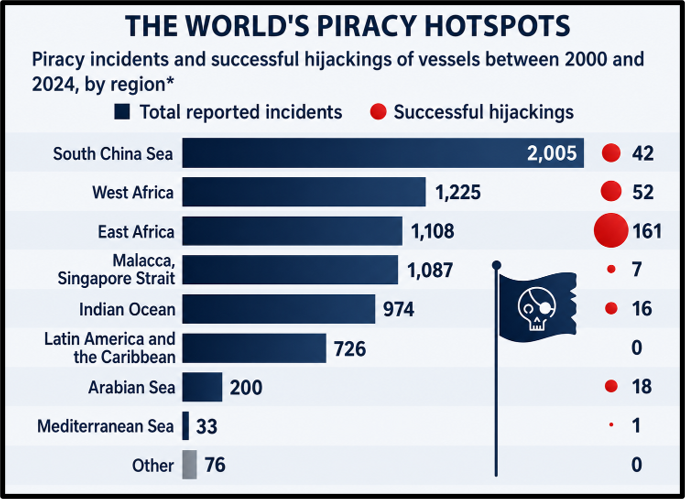
Layered over this strategic rivalry are the non-traditional threats: piracy re-emerging from the Gulf of Aden, illegal, unreported and unregulated (IUU) fishing that strips the ocean’s resources, and maritime terrorism. India’s Navy has patrolled the piracy-prone waters since 2008, escorting thousands of merchant ships, and Parliament has strengthened its legal hand through the Anti-Maritime Piracy Act, 2022.
| CASE STUDY · The Anti-Maritime Piracy Act, 2022 — closing a legal gap Until 2022 India had no dedicated anti-piracy law, forcing it to prosecute captured pirates under ordinary criminal law ill-suited to crimes on the high seas. –The Act adopts the UNCLOS definition of piracy and applies to the high seas and the Exclusive Economic Zone, beyond any single state’s jurisdiction. –It makes piracy an extraditable offence, provides for designated courts for speedy trial, and empowers authorised forces to arrest and seize pirate vessels. –A concern flagged in debate is the provision of the death penalty, seen by critics as sitting uneasily with the ‘rarest of rare’ doctrine and constitutional guarantees. The Act lets India play a fuller role in securing the global commons on which its own trade depends. |
Maritime Piracy
- The United Nations Convention on the Law of the Sea (UNCLOS), 1982 defines piracy as acts of violence, detention, or destruction, committed for private ends, against persons or property on board a ship on the high seas or outside the jurisdiction of any State.
- Piracy is different from armed robbery at sea. Armed robbery takes place within a country’s territorial waters and falls under the jurisdiction of the concerned coastal State
From SAGAR to MAHASAGAR — Maritime Diplomacy and the Blue Economy
India’s answer to the ocean contest is less a race to build bases than a bid to be the region’s preferred security partner.
This was framed in 2015 as the vision of SAGAR — Security and Growth for All in the Region — and elevated in 2025 into MAHASAGAR — Mutual and Holistic Advancement for Security and Growth Across Regions — a broader, more global maritime outreach that folds in economic diplomacy, capacity-building and sustainability, and offers a cooperative alternative to a purely transactional model of influence.
This diplomacy runs through a web of institutions: the Indian Ocean Rim Association for economic cooperation, the Indian Ocean Naval Symposium and the MILAN exercise for navy-to-navy trust, and the Colombo Security Conclave for regional security coordination.
Underpinning it all is the promise of the blue economy — the sustainable use of ocean resources for growth, from fisheries and shipping to the submarine fibre-optic cables that carry the digital economy — which gives every littoral state a shared stake in a secure, open ocean.
| CURRENT STATUS (as of August 2026) The Colombo Security Conclave now has five members — India, Sri Lanka, Maldives, Mauritius and Bangladesh (joined 2024) — with Seychelles as an observer, focusing on maritime safety, counter-terrorism, trafficking and cyber security. The MAHASAGAR vision was articulated during the Prime Minister’s visit to Mauritius in early 2025, signalling a wider, Global-South-facing maritime engagement built on the SAGAR foundation. |