Fronts
Fronts and Frontogenesis
Imagine the atmosphere as a huge battlefield where different armies of air are always in motion. These armies are called air masses — large bodies of air that have uniform characteristics like temperature, humidity, and pressure.
Now, what happens when two very different air masses face each other? For example:
- On one side: cold, dense, and dry air.
- On the other side: warm, light, and moist air.
The line where they meet is not a straight wall, nor is it vertical. Instead, it’s a sloping boundary, inclined gently against the Earth’s surface. This sloping dividing line is called a front.
🔹 Frontal Zone / Frontal Surface – Actually, it’s not just a line, but an extensive transitional zone where properties like temperature, pressure, humidity, and wind direction change abruptly. Meteorologists call this the frontal zone or frontal surface. It is essentially a zone of discontinuity.
Definition: When two different air masses meet, the boundary zone between them is called a front. So, the fronts are three-dimensional area, acts as a transition zone and has sloping boundaries which extends vertically as well as horizontally.
Common Features of Fronts
Although fronts can differ in their location, type, or size, they share some signature characteristics:
- Sharp temperature differences across the front.
- Bending of isobars (lines of equal pressure).
- Most of the fronts associated with LP conditions and there are points called “Kinks” where there is abrupt change in pressure
- Sudden shift in wind direction as you cross the front.
- Cloudiness and precipitation due to uplift of warm moist air.
So whenever you see these four signs on a weather map or in real atmosphere, you can suspect — a front is present here.
Frontogenesis vs. Frontolysis
- The formation or intensification of a front is called frontogenesis.
- The destruction or weakening of a front is called frontolysis.
Thus, wherever two contrasting air masses converge strongly, you are in a region of frontogenesis.
Interesting Fact: Frontogenesis is a Norwegian Concept. Tor Bergeron used the term frontogenesis to indicate the formation of a new front. But he couldn’t explain the real reasons behind the formation of kink and frontogenesis.
Definition of Frontogenesis: The process by which two air masses of different characteristics are brought together, thus setting in motion for the formation of a depression is called as frontogenesis
Conditions For Frontogenesis and Frontolysis
Now, do these fronts form everywhere in the world?
No. They form only in specific regions, because some favourable conditions are needed.
The two most important conditions are:
1. Temperature Difference
- The two air masses must have contrasting temperatures.
- Example: Cold, dry, dense air meeting warm, moist, light air.
- In such cases, the cold dense air pushes beneath the lighter warm air, forcing it upward — and thus a front develops.
👉 A very interesting observation:
Even though winds converge at the Equator, we don’t get fronts there. Why? Because the temperatures of both converging trade winds are almost the same — no sharp contrast. Without a temperature difference, no front can form.
(Some meteorologists have debated small-scale frontogenesis near the equator, but generally, it is negligible compared to mid-latitudes.)
2. Opposite Directions of Air Masses (Convergence)
For a front to form, the air masses must meet head-on.
- If they converge → a front develops.
- If they diverge → fronts break down (frontolysis).
This is where Patterson’s classification of air circulations becomes important. He identified four types of air circulation. Let’s understand them one by one:
(i) Translatory Circulation
- Air moves horizontally in the same direction (A).
- Isotherms (lines of equal temperature) remain parallel and far apart.
- ❌ No temperature contrast → No frontogenesis.
(ii) Rotatory Circulation
- Air circulates in a cyclonic or anticyclonic pattern (B, C).
- This does create some temperature variations, but not in the way required for a front.
- ❌ Hence, no front is formed here either.
(iii) Convergent and Divergent Circulation
- Convergent circulation → Winds meet at a common point (D).
- Divergent circulation → Winds spread out from a central point (E).
Now, convergence does create temperature differences — but only at a point, not along a line.
👉 For frontogenesis, we need linear temperature contrast (a boundary), not just a point.
- ❌ So, this too does not favour proper front formation.
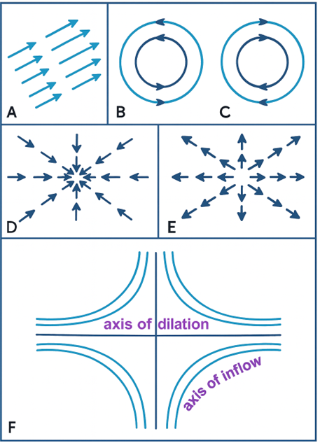
D= convergent circulation, E = divergent circulation, and F = deformation circulation.
(iv) Deformatory Circulation
This is the most important one.
- Here, two contrasting air masses not only converge, but also spread out horizontally along a line.
- This line is called the axis of outflow (or dilation), while the perpendicular one is the axis of inflow (F).
✅ This system produces the ideal conditions for frontogenesis — because it sets up the necessary linear boundary between cold and warm air.
Conditions for Frontolysis:
“Byers” had mentioned two conditions for frontolysis:
- The temperature contrast diminishes
- There is divergence of air
Concept of Barocliny
Background
In the Polar Front Theory, two conditions were considered essential for front formation:
- Temperature contrast (between warm tropical air and cold polar air)
- Convergence of air masses
This theory explained a lot, but it couldn’t fully describe why a kink (wave) develops on the front line, which is the actual trigger of a cyclone.
Modern meteorology introduced the idea of barocliny to explain this.
What is Barocliny?
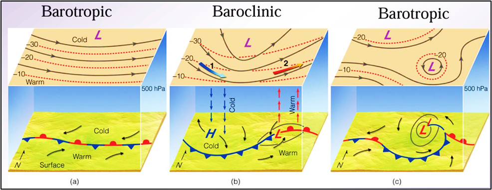
- In a barotropic atmosphere:
- Lines of equal temperature (isotherms) and lines of equal pressure (isobars) are parallel.
- This means temperature does not vary along a pressure surface → stable atmosphere.
- In a baroclinic atmosphere:
- Isotherms cut isobars at an angle.
- This means temperature changes along pressure surfaces, and density varies both with pressure and temperature.
- Such a condition produces instability → perfect ground for cyclogenesis.
So, barocliny = isotherms crossing isobars, creating potential for energy conversion and disturbances.
Why Barocliny Creates the “Kink”
- When isotherms and isobars cross, it means warm and cold air masses are slanted against pressure surfaces.
- This sloping arrangement makes the front line unstable → waves (kinks) begin to develop on the polar front.
- These waves then deepen into cyclones.
Importance in Cyclone Formation
- Energy Source: Baroclinic zones convert available potential energy (due to temperature gradients) into kinetic energy (winds, cyclonic circulation).
- This is the scientific basis of the Baroclinic Wave Theory, which improved upon the Polar Front Theory.
- Without barocliny, the atmosphere would remain barotropic (stable) → no significant cyclone formation.
🎯 In Simple Words
- Barotropic: Stable, calm, no cyclone — isotherms and isobars run parallel.
- Baroclinic: Unstable, dynamic, cyclone-friendly — isotherms cut isobars, creating kinks on fronts.
👉 So, barocliny is the real physical reason behind the birth of temperate cyclones. It explains why waves (kinks) appear on the polar front and grow into cyclones.
Creation Of Fronts
We have already understood that deformatory circulation provides the best conditions for frontogenesis. Now, let’s see how exactly a front gets created.
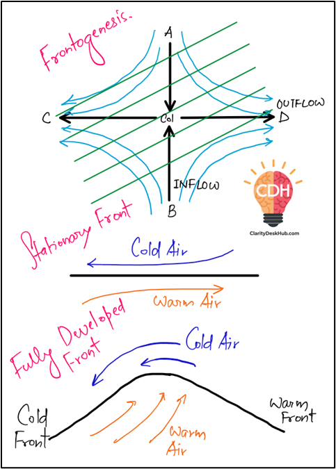
Imagine two contrasting air masses converging. Due to deformatory circulation, they spread horizontally along a line called the axis of outflow (or dilation).
But here comes the key point:
👉 The formation of a front depends on the angle between the axis of outflow and the isotherms (lines of equal temperature).
- If this angle is more than 45°, no front is formed.
- As convergence continues, the angle decreases.
- When isotherms start becoming parallel to the axis of outflow → frontogenesis begins.
Steepness & Intensity of Fronts
The character of a front depends heavily on the temperature gradient:
- Stationary Arrangement:
- If the two contrasting air masses are parallel to each other, and there is no upward displacement of warm air, a stationary front develops
- ❌ This type is climatically insignificant — no strong cloud formation, no major precipitation.
- Sloping Arrangement (more common):
- Usually, the Earth’s Coriolis force and the density difference between cold and warm air prevent a perfectly parallel arrangement.
- The cold, heavy air pushes the warm, light air upward along a sloping surface
- ✅ This sloping boundary is the real active front, associated with clouds and precipitation.
📌 Note: Fronts are not perfectly linear; they are zonal in character. Their width can vary from 5 km to as much as 80 km.
Classification of Fronts
Based on their formation and weather characteristics, fronts are classified into four main types:
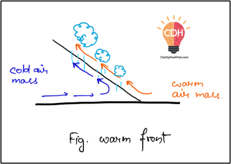
1. Warm Front
- A warm front is a gently sloping surface where warm, lighter air which is more active rises gradually over cold, denser air
- Slope: Very gentle → ranging from 1:100 to 1:400.
- (Meaning: for every 100–400 km horizontally, the front rises just 1 km vertically.)
- Process: Warm air ascends slowly, cools adiabatically, condenses, and forms a series of clouds.
- Weather:
- Precipitation is gentle to moderate, but covers a large area.
- Duration: Several hours (sometimes even a day or two).
- No violent storms, but long and steady rainfall.
👉 Hence, warm fronts bring persistent, widespread, and steady rain or snow in middle latitudes.
These types of warm fronts are called Ana type warm front. Here term “Ana” means upwards.
Now, let us discuss another type of warm front called Kata type warm front:
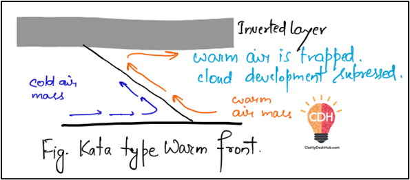
Kata Type Warm Front:
- Term “kata” = downward.
- Here, instead of rising along the slope, the warm air moves downward (descends) relative to the frontal surface.
- This suppresses vertical uplift and creates a stable layer of warm air above cooler air near the front.
- This situation leads to a temperature inversion:
- Features:
- Weaker cloud formation (often stratiform, thin).
- Little or no precipitation.
- Since uplift is limited, these warm fronts are drier and less significant in terms of weather.
👉 Think of it as a “lazy” or “inactive” warm front — warm air doesn’t rise enough to give much rain.
2. Cold Front
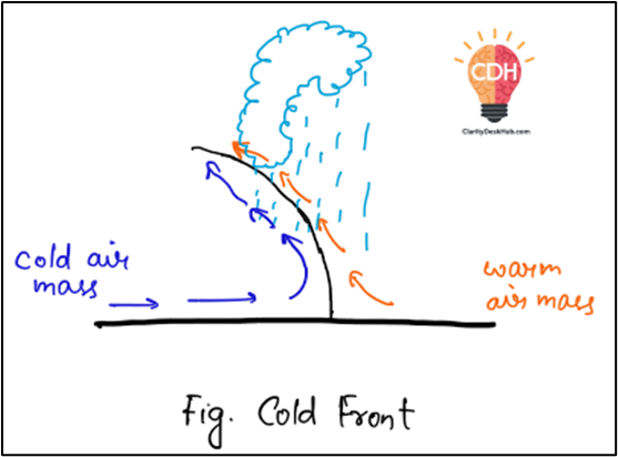
- A cold front forms when cold air becomes aggressive, invades warm air territory, and being denser, stays close to the ground, forcibly uplifting the warm air.
- Slope: Much steeper than warm front → between 1:50 and 1:100.
- (Meaning: rises 1 km for every 50–100 km horizontally.)
- Cause: The bottom layer of cold air is slowed by friction, but the upper layers advance faster → making the front steeper.
- Weather:
- Associated with violent and short-lived weather.
- Thick cumulonimbus clouds, thunderstorms, lightning, heavy showers.
- In colder regions → snowfall or even hailstorms.
👉 Cold fronts = dramatic but short-duration weather events.
Now, this cold front that we have discussed is called as Ana type of cold front which is more common.
UPSC Note: If a direction question on Fronts or temperate cyclone comes you need to mention Ana type only.
So, now let us discuss another type of cold front called as Kata Type of Cold Front
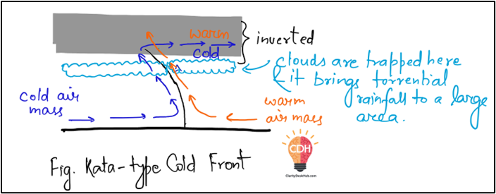
Kata-type Cold Front
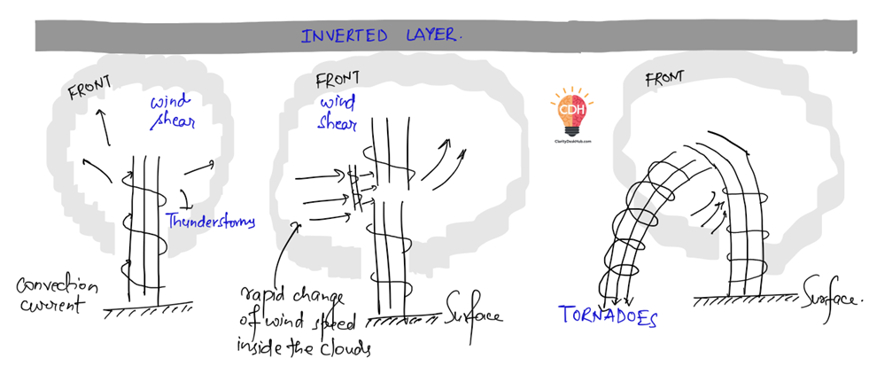
A kata-type of cold front develops when an inverted layer forms over the cold front. If the rising air has less moisture, then Stratus clouds and Strato-cumulus clouds will be visible in the sky, and the front may pass without any instability or disturbances.
But if the rising warm air is extremely humid, it will create extreme instability and may lead to formation of supercell thunderstorms, which in extreme cases can develop into tornadoes.
Along the Kata front strong wind shear is always there with increasing height which leads to spiraling movement in the upper air drafts. Instead of entering straight the draft seems entering from side due to strong wind shear. The down draft becomes stronger with time and comes out towards the ground as tornado
3. Occluded Front
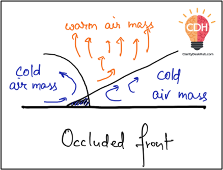
- An occluded front forms when a cold front overtakes a warm front.
- The warm air is completely lifted off the ground surface and squeezed aloft
- This marks the mature or decaying stage of a cyclone, when the warm sector is eliminated.
👉 Weather: Complex → often prolonged cloudiness, rain, and sometimes storms.
4. Stationary Front
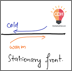
- A stationary front occurs when two contrasting air masses converge but end up becoming parallel to each other.
- There is no significant upward movement of air.
- The position of the front does not move forward or backward
- Weather: Usually insignificant → little or no precipitation.
Here fronts almost degenerate into a line which is separated by regions of different velocity winds. This area is referred to as shear line.
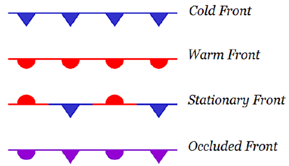
Symbols for different types of fronts:
