
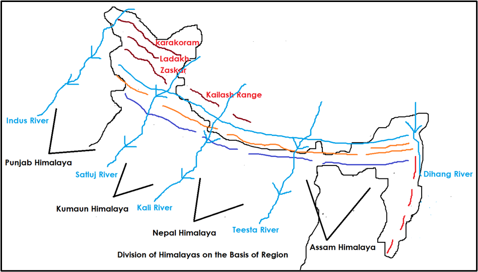
Regional Division of the Himalayas
The Himalayas, though a single mountain system, show regional variations in their physiography, drainage, climate, vegetation, and human life. That’s why geographers divide them into three main sectors:
- Western Himalayas (Indus → Kali River)
- Central Himalayas (Kali → Tista)
- Eastern Himalayas (Tista → Brahmaputra/Dihang)
Western Himalayas
In this section we’ll focus on the Western Himalayas, which extend for about 880 km from the Indus in the west to the Kali/Sharda River in the east.
This region covers Jammu & Kashmir, Ladakh, Himachal Pradesh, and Uttarakhand.
Punjab Himalayas
- Located between Indus and Sutlej rivers (~560 km long).
- Spread across J&K and Himachal Pradesh.
- Commonly called the Kashmir and Himachal Himalayas.
Major Ranges:
- Karakoram
- Ladakh
- Pir Panjal
- Zaskar
- Dhauladhar
👉 Here, all rivers of the Indus system (Indus, Jhelum, Chenab, Ravi, Beas, Sutlej) flow westwards.
👉 General elevation decreases westward.
Kashmir Himalayas
This part is most diverse and unique.
Ranges present: Karakoram, Ladakh, Zanskar, Pir Panjal.
Glaciers: Baltoro, Siachen (world’s largest outside poles).
- Northeastern corner → Aksai Chin, a cold desert.
Valleys & Lakes:
- Kashmir Valley between Great Himalayas & Pir Panjal.
- Freshwater lakes: Dal, Wular.
- Saltwater lakes: Pangong Tso, Tso Moriri.
Passes:
- Zoji La → Zanskar Range.
- Banihal → Pir Panjal.
- Photu (Fotu) La → Zaskar.
- Khardung La → Ladakh Range.
Drainage:
- Rivers → Indus, Jhelum, Chenab.
- Srinagar lies on the Jhelum.
Pilgrimage Centres:
Vaishno Devi, Amarnath Cave, Charar-e-Sharif.
Himachal Himalayas
- Lies between Ravi (west) and Kali/Sharda (east).
- Drained by both Indus system (Ravi, Beas, Sutlej) and Ganga system (Yamuna, Ghaghara).
Ranges:
- Pir Panjal & Dhauladhar (Lesser Himalaya).
- Shiwalik (Outer Himalaya).
- Himadri also present.
Physiography:
- Southern slopes → rugged, steep, forested.
- Northern slopes → bare and gentle.
- Northernmost part (Spiti, Lahul subdivisions) = extension of Ladakh cold desert.
Human Settlements:
- Altitude 1000–2000 m → favourite for British colonial hill stations like Shimla, Mussoorie, Dharamshala, Kasauli, Almora, Ranikhet, Lansdowne.
Kumaon Himalayas
- Located in Uttarakhand → between Sutlej and Kali Rivers.
Inhabitants:
- Valleys occupied by Bhotias, a nomadic group.
- Practice transhumance → migrate to Bugyals (alpine pastures) in summer, return to valleys in winter.
Ranges:
- Mussoorie & Nag Tibba ranges (Lesser Himalaya).
- Shiwalik Range → south of Mussoorie, between Ganga & Yamuna rivers.
Special Physiographic Features:
- Presence of Shiwalik and Dun formations (longitudinal valleys between Lesser Himalaya & Shiwaliks).
- Dehra Dun is the most famous dun (35–45 km long, 22–25 km wide).
Central Himalayas
Extent
- Stretch: 800 km between the Kali River (Sharda) in the west and the Teesta River in the east.
- This includes Nepal Himalayas and parts of Sikkim Himalayas.
Key Features
- The Great Himalaya (Himadri) reaches its maximum height here.
- World-famous peaks:
- Mount Everest (8848 m)
- Kanchenjunga (8598 m)
- Makalu, Annapurna, Dhaulagiri, Gosainthan.
- The Lesser Himalaya in this region is called the Mahabharat Lekh.
- Major rivers: Ghaghara, Gandak, Kosi — they cut across the ranges.
Valleys
- Between Himadri and Himachal lie the famous Kathmandu Valley and Pokhara Valley.
- Both were once lake basins, later drained by river erosion.
Shiwalik Range
- The Shiwaliks are present but become narrow and discontinuous beyond the Narayani (Gandak River).
Eastern Himalayas (Assam Himalayas)
Extent
- From Teesta River (west) to Brahmaputra River (east), about 720 km long.
Key Features
- Lower elevation compared to Nepal Himalayas.
- Dominated by fluvial erosion due to heavy rainfall.
- Slopes:
- South slopes → steep.
- North slopes → gentler.
- Lesser Himalayas are narrow and lie close to the Greater Himalayas.
- Shiwaliks → almost absent.
- Beyond Dihang Gorge, the Himalayas suddenly bend southwards → giving rise to the Purvanchal Hills.
Sikkim Himalayas
- Known for:
- High peaks → Kanchenjunga.
- Fast-flowing rivers → Teesta.
- Deep valleys → spectacular landscapes.
- Population:
- Lepchas → in higher altitudes.
- Darjeeling region → Nepalis, Bengalis, tribals from Central India.
- Shiwaliks absent here → replaced by Duar formations, which have fertile soils → famous for tea plantations (Darjeeling Tea).
- Rich in flora (orchids) and scenic beauty → global tourism hub.
Arunachal Himalayas
- Extent: East of Bhutan Himalayas → Diphu Pass.
- Prominent peaks: Kangto, Namcha Barwa (7756 m).
- Rivers: Kameng, Subansiri, Dihang, Dibang, Lohit.
- Perennial, steep gradient → highest hydroelectric potential in India.
- Terrain: deeply dissected by rivers, creating gorges.
- Transport: difficult due to ruggedness; movement often through the duar region along Arunachal–Assam border.
Tribal Communities:
- Monpa, Daffla, Abor, Mishmi, Nishi, Nagas.
- Most practice Jhum (slash-and-burn cultivation).
- Rich in biodiversity, preserved by indigenous traditions.
Tea Plantations:
- Introduced by the British due to:
- Fertile soils with organic matter,
- Heavy rainfall,
- Mild winters.
- Assam & Arunachal → globally renowned tea-producing regions.
Eastern vs Western Himalayas
| Feature | Eastern Himalayas | Western Himalayas |
|---|---|---|
| Relief | Rise abruptly from plains (Bengal, Oudh). | Rise gradually through successive ranges. |
| Proximity to Plains | Peaks like Everest, Kanchenjunga very close to plains. | Snow peaks 150–200 km away from plains. |
| Rainfall | High (monsoonal, >200 cm), leads to intense erosion. | Lower (due to continentality). |
| Vegetation | Evergreen, dense forests, orchids. | Dry, alpine vegetation in higher reaches. |
| Shiwaliks | Absent or negligible. | Well developed. |