Temperate Cyclones
When we hear the word cyclone, we often imagine massive storms near the equator like hurricanes or typhoons. But in reality, the cyclones that dominate the weather of Europe, North America, and much of Asia are not tropical—they are called temperate cyclones. These are also known as:
- Extratropical cyclones – because they form outside the tropics, in mid-latitudes.
- Frontal cyclones – because their very birth happens along fronts (the meeting zones of contrasting air masses).
- Wave cyclones – because their shape often looks like a wave on weather maps.
- Depressions / Lows – because at the centre of these systems, pressure is always low.
Basic Nature
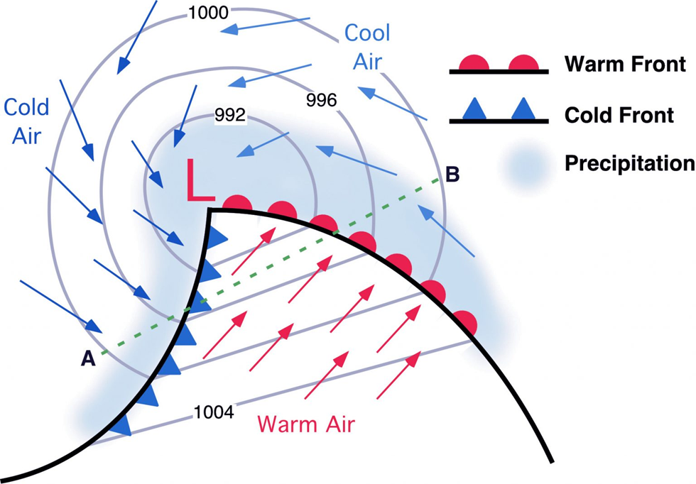
- Structure: A temperate cyclone is a low-pressure system with winds converging towards the centre and then rising upward.
- Weather: Rising air means cloud formation, precipitation, and stormy weather.
- Shape: They can appear circular, elliptical, or wedge-shaped (V-shaped)—hence the different names given by meteorologists.
- Location: They form between 35° and 65° latitudes in both hemispheres—this is the classic “temperate belt.”
- Cause: They originate where warm, moist, light tropical air masses clash with cold, dense polar air masses. The boundary between them is the polar front, and this front is the birthplace of these cyclones.
- Movement: After formation, they are carried eastward by the westerlies, thus controlling much of the day-to-day weather in mid-latitudes.
👉 In short: Temperate cyclones are the ‘weather-makers’ of Europe, USA, Russia, etc. That’s why forecasts in London or New York are often about “low-pressure depressions moving eastward.”
Types of Temperate Cyclones
Not all temperate cyclones are born in the same way. Broadly, three types are identified:
1. Dynamic Cyclones (the “Real” Temperate Cyclones)
- Formed by the convergence of cold polar air and warm maritime tropical air.
- These are the classic, textbook cyclones that dominate middle latitudes.
- They are dynamic because their very origin is a result of dynamical processes—the invasion and struggle of two air m
- asses into each other’s territory.
- Structure: Warm front, cold front, warm sector, cold sector are all well developed.
- Impact: They can influence the weather of very large areas, sometimes entire continents.
2. Thermal Cyclones
Now, these are a bit different. Instead of being born from the fight of two air masses, they arise due to temperature contrasts caused by insolation (solar heating).
- Brunt’s View: In summer, large landmasses in temperate regions heat up. This creates low-pressure centres on continents, and winds blow in from all directions. Example: Iberian Peninsula, Alaska, SW USA, NW Australia.
- Humphreys’ View: In winter, the situation reverses. Large landmasses are extremely cold, while nearby seas are relatively warm. Over these warm waters, low-pressure centres develop. Example: Okhotsk Sea, Norwegian Sea, south of Iceland and Greenland.
- Common Feature: Both are linked to direct heating (insolation) and thus called thermal or insolation cyclones.
- Limitation: They are stationary, smaller in scale, and do not have well-developed fronts like dynamic cyclones.
3. Secondary Cyclones
- These are short-lived, weak disturbances.
- They develop after the occlusion stage of a main cyclone—when cold winds sweep over a warm sea surface.
- Because they are temporary and weak, they don’t usually have a big impact.
🌐 In Summary
- Dynamic cyclones = the true wave cyclones of mid-latitudes, caused by clash of polar vs tropical air.
- Thermal cyclones = created by solar heating contrasts (over land in summer, over sea in winter).
- Secondary cyclones = small, weak systems born after the main cyclone has occluded.
👉 If tropical cyclones are like violent but localized giants near the equator, temperate cyclones are like regular visitors in the temperate world, quietly shaping everyday weather patterns.
Shape, Size and Velocity
When we observe temperate cyclones on weather maps, one striking feature is that no two cyclones look exactly the same.
- Shape: They may be circular, semi-circular, elliptical, elongated, or even V-shaped. But one feature is common:
- A low-pressure centre surrounded by closed isobars (lines joining equal pressure points).
- Pressure difference:
- Normally 10–20 mb between the centre and periphery.
- Occasionally can rise up to 35 mb in strong systems.
- Size:
- On average, a cyclone stretches about 1900 km in diameter (longest axis).
- The shorter axis is around 1000 km.
- But extremes are possible: from as small as 150 km to as large as 3000 km in diameter.
- Some huge cyclones can cover nearly 1 million square kilometres—larger than many countries combined!
- Vertical extent: About 10–12 km into the atmosphere.
- Velocity of movement (eastward, with westerlies):
- Summer: Around 32 km/h
- Winter: Faster, about 48 km/h (because the polar front is more active and contrasts sharper in winter).
👉 Takeaway: Temperate cyclones are giant systems—much larger than tropical cyclones—and they travel steadily across continents like moving weather factories.
Wind System
Now, let’s understand the circulation pattern inside a temperate cyclone.
- Basic rule: Winds always blow from high pressure to low pressure.
- But due to the Coriolis force and friction with Earth’s surface, winds don’t move straight into the low-pressure centre. Instead, they cross the isobars at an angle of 20°–40°.
- Direction of circulation:
- Northern Hemisphere: Anticlockwise spiral inward.
- Southern Hemisphere: Clockwise spiral inward.
🔄 What happens to the winds at the centre?
- Winds converge toward the low pressure, but they cannot pile up there.
- Instead, they rise upward and spread outward at higher levels.
- This constant upward escape maintains the low pressure core as long as the cyclone survives.
Variation across different sectors
Remember: A temperate cyclone is born at the polar front, where cold polar air meets warm tropical air.
Thus, different sectors have different wind directions:
- Before the Warm Front: Winds blow from east or southeast.
- Warm Front & Warm Sector: Winds shift to southerly and southwesterly. These are warmer winds.
- Cold Front & Cold Sector: Winds turn suddenly to west, northwest, or north, bringing in cold air.
📍 This sudden change in wind direction along fronts is very sharp and noticeable. The line where this happens is called the Wind Shift Line.
👉 This is why meteorologists often predict the arrival of a cyclone or its fronts by closely observing wind shifts.
Temperature Pattern
Because temperate cyclones are essentially a battlefield between warm tropical air and cold polar air, temperature varies greatly within the system.
- Southern part of cyclone: Dominated by warm tropical air → higher temperature.
- Northern, northeastern, and northwestern parts: Dominated by cold polar air → lower temperature.
- Western part: Often records the lowest temperature, because of strong cold air intrusion behind the cold front.
📍 On weather maps, the isotherms (lines of equal temperature) tend to align in a north-northeast to southwest direction in the Northern Hemisphere. This shows how warm and cold sectors stretch across the system.
Source Regions and Tracks of Movement
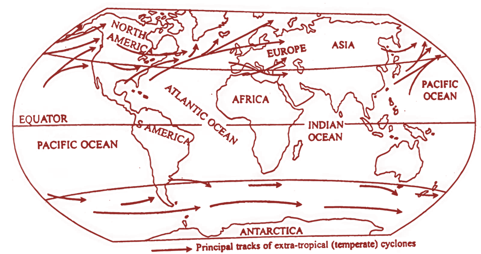
Temperate cyclones are not random — they have favourite breeding grounds in the mid-latitudes (between 35°–65° N and S). After forming, they usually travel eastward with the westerlies, but since no two systems are identical, their tracks are studied in broad zonal patterns (called storm tracks) rather than precise straight lines.
Major Source Regions
- North Pacific (off northwest North America)
- Birthplace of strong cyclones.
- They move northeast and often merge with the Aleutian Lows in the Gulf of Alaska.
- Some may travel as far south as California.
- Inland cyclones weaken and die on the western slopes of the Rockies.
- Interior North America (Frontogenesis zones)
- East of Sierra Nevada Range.
- Eastern Colorado → Colorado Lows.
- East of Canadian Rockies → Alberta Lows.
- Great Lakes region.
- Gulf of Mexico
- Cyclones here move northeastward, passing east of the Appalachians, and merge with the Icelandic frontogenesis zone.
- Northwest North Atlantic (off northeast North America)
- Cyclones here move eastward and influence northwest Europe.
- Iceland to Barents Sea
- Path runs eastward, controlling the weather of northern Europe.
- Continental Europe
- Two key zones: Baltic Sea and Mediterranean Sea.
- Mediterranean cyclones are particularly important:
- Many move eastward into Pakistan and north India during winter → responsible for western disturbances and much of the winter precipitation in these regions.
- Most, however, move northeast towards the CIS (former USSR region).
👉 Summary: The mid-latitude cyclones act like travelling “weather factories,” steering rainfall and snow across North America, Europe, and Asia. For India, their Mediterranean branch is especially significant in Rabi crop irrigation (winter rainfall).

Weather Conditions Associated with Temperate Cyclones
Why do temperate cyclones dominate daily weather in mid-latitudes? Because as they pass, they bring a sequence of weather changes at any observation point. Let’s break it into stages:
(i) Arrival of Cyclone (before warm front)
- Wind slows, pressure begins to fall.
- Thin cirrus and cirrostratus clouds appear; sun or moon may be surrounded by a halo.
- Temperature rises suddenly.
- Wind direction shifts from easterly → south-easterly.
- Sky thickens with dark, low clouds → storm is approaching.
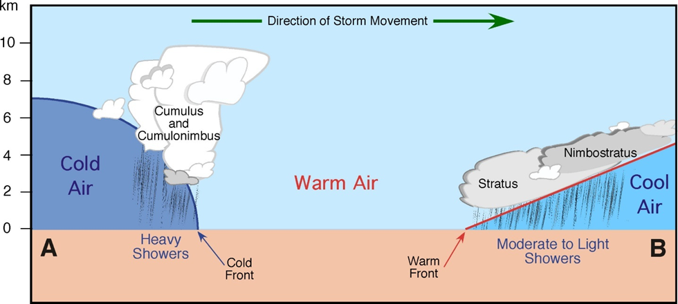
(ii) Warm Frontal Precipitation
- As the warm front arrives, cloud cover thickens into nimbostratus.
- Rain begins — slow, steady, and prolonged because warm air is rising gently over cold air.
- The sky remains overcast for hours.
(iii) Warm Sector
- After the warm front passes, the warm sector arrives.
- Weather changes suddenly:
- Winds become southerly or southwesterly.
- Sky clears, sunshine appears.
- Temperature rises, humidity increases, pressure falls.
- Weather is generally pleasant but humid, with occasional drizzle.
(iv) Cold Front Arrival
- A sudden drop in temperature.
- Cold air pushes warm air upward abruptly.
- Wind shifts from southerly → southwesterly/westerly.
- Sky darkens again and rain begins.
(v) Cold Frontal Precipitation
- Cumulonimbus clouds dominate.
- Precipitation is intense but short-lived (showers, thunderstorms).
- Often accompanied by lightning, thunder, hailstorms.
- More violent but less widespread than warm front rainfall.
(vi) Cold Sector
- After the cold front passes:
- Weather clears rapidly.
- Temperature drops sharply.
- Pressure rises again.
- Humidity decreases.
- Winds settle into true westerlies.
- After occlusion (final stage), the area returns to pre-cyclone weather conditions.
🎯 Key Understanding
- Storm Tracks: Preferred “routes” in mid-latitudes (Pacific, Atlantic, Mediterranean, etc.).
- Weather Sequence: A moving cyclone gives a textbook pattern → cirrus halo → steady warm front rain → warm pleasant interlude → sudden cold front storm → clear but cold conditions.
👉 In simple words: A temperate cyclone is like a travelling weather drama—entering with light clouds, then bringing long rain, followed by a sunny pause, then a violent storm, and finally cold, clear weather.


Origin & Life Cycle of Temperate Cyclones
Early Theories of Origin
Meteorologists struggled for a long time to explain cyclogenesis (the birth of cyclones). Let’s look at the milestones:
- Fitzroy (1863):
- First serious attempt.
- Said that cyclones form due to convergence of two contrasting air masses (different in temperature, density, pressure, humidity).
- Shaw & Lempfert (1911): Dynamic Theory
- Cyclones form because of winds converging from all directions toward a low-pressure centre.
- Convection Current Theory:
- Explained cyclones as vertical convection currents in the atmosphere.
- Rejected — too simplistic for large-scale systems.
- Eddy Theory:
- Proposed that eddies (whirl-like motions) created by obstructions in moving air masses generate cyclones.
- Polar Front Theory (Wave Theory / Bergen Theory, 1918):
- Given by V. Bjerknes and J. Bjerknes (Norwegian meteorologists).
- Became the most accepted and classical theory.
- Explained extratropical cyclones as a result of instabilities along the polar front, where cold polar air and warm subtropical air meet.
- Baroclinic Wave Theory (Modern):
- Uses satellite and radar data.
- Cyclones form due to baroclinic instability in middle and upper troposphere.
- Builds on and modernizes the polar front theory.
Polar Front (Wave) Theory – The Classical Explanation
This is the standard theory UPSC expects you to know in detail.
- In mid-latitudes, two contrasting air masses meet:
- Cold Polar Air: cold, dense, stable, moving from northeast.
- Warm Tropical Air: warm, moist, lighter, moving from southwest.
- When they meet, a stationary front is formed (both moving parallel, no vertical movement).
- If these masses start to penetrate each other’s territory, the front becomes unstable and wavy → a polar front.
- Development of the wave:
- The eastern part of the wave: warm air overrides cold → Warm Front.
- The western part of the wave: cold air undercuts warm air → Cold Front.
- Between them lie sectors:
- Warm Sector (southwest) → warm, moist air.
- Cold Sector (northwest) → cold, dense air.
- Low pressure deepens at the centre because warm air rising draws in winds from surrounding areas.
- The cyclone matures, with spiraling winds, rainfall, and shifting weather conditions.
Occlusion and Death of Cyclone
- The cold front advances faster than the warm front.
- Eventually, the cold front overtakes the warm front, lifting the remaining warm air completely.
- The warm sector disappears → an occluded front forms.
- Without energy from warm air, the cyclone weakens and dies.
- Sometimes, small secondary cyclones (sub-cyclones) form after occlusion if some warm air remains trapped.
Life Cycle of a Temperate Cyclone
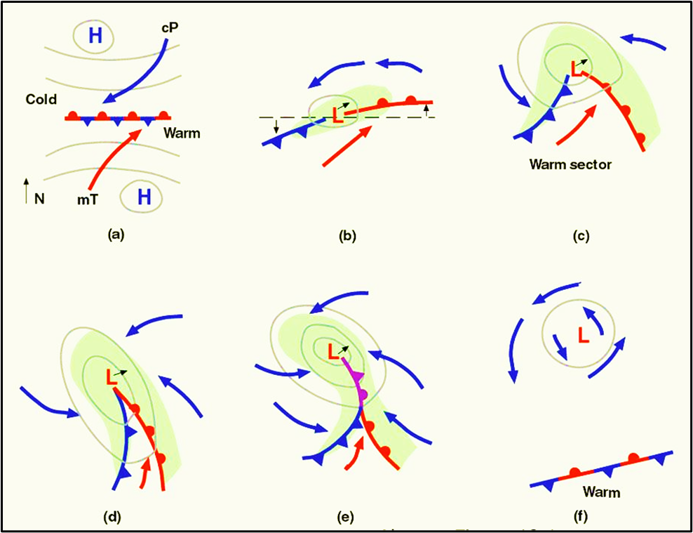
The journey from birth to death is quite systematic — typically lasting 5–7 days.
- First Stage (Initial/Stationary Front):
- Two contrasting air masses meet, moving parallel → stationary front forms.
- Second Stage (Incipient Stage):
- Front becomes wavy as warm and cold air penetrate each other.
- Third Stage (Mature Stage):
- Cyclone fully develops.
- Circular isobars form around the low-pressure centre.
- Warm and cold fronts are distinct.
- Fourth Stage:
- Cold front moves faster, narrowing the warm sector.
- Fifth Stage (Occlusion):
- Cold front overtakes warm front.
- Occluded front develops.
- Sixth Stage (Dissipation/Frontolysis):
- Warm sector vanishes.
- Energy supply (from rising warm air) is cut off.
- Cyclone dies out.

🎯 Key Takeaways
- The Polar Front/Wave Theory remains the most important explanation.
- A temperate cyclone’s life is a battle between warm and cold air masses.
- Birth at stationary front → wave development → mature low → occlusion → death.
- Life span: About a week, but during this time it controls weather across vast regions.
👉 In simple words: A temperate cyclone is like a grand drama. It begins quietly when two air masses stare at each other, then tension rises as they clash, the drama peaks with storms and rain, and finally ends when the cold air wins, pushing warm air off the stage.
