
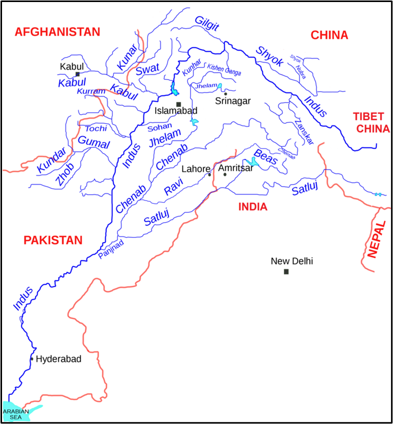
The Indus River System
Think of this river system like a huge tree, with the Indus River as the main trunk, and many big and small branches (tributaries) feeding into it. This tree starts in the Himalayas and ends in the Arabian Sea. It is one of the largest river systems in the world.
In ancient times, this river was called Sindhu. From Sindhu came Hind, and eventually India. So, quite literally, India is named after this river. That’s how important it is in our geography and history.
The Origin and Course of Indus River
- Source: Glaciers near Mansarovar Lake in Tibet, close to Kailash Range.
- Direction: Flows northwest initially, then turns sharply south near Nanga Parbat, and finally enters Pakistan.
- Length: Around 2,880 km total, out of which 1,114 km is in India.
- Elevation: In Jammu & Kashmir, it flows at an average height of 4000 m, gently descending at just 30 cm per km.
📍It flows through:
- Tibet, then Ladakh, Baltistan, Gilgit, and finally enters Pakistan.
📍Notable points:
- Joined by Zaskar River at Leh.
- Joined by Shyok River near Skardu (at 2700 m elevation).
- Crosses the Himalayas through a deep 5181 m gorge, taking a dramatic syntaxial bend near Nanga Parbat.
- In Pakistan, joined by Kabul River (from Afghanistan) near Attock.
- Receives smaller tributaries like Kurram, Toch, and Zhob-Gomal.
- Finally, gets the combined waters of five eastern tributaries through Panjnad and ends in the Arabian Sea near Karachi, forming a massive delta.
The Five Eastern Tributaries (Punjab ke Panch Nadiyan)
Let’s now understand the five main tributaries that come from the east (mostly from India) and join the Indus via the Panjnad.
To remember the order from left (west) to right (east):
👉 Indus – Jhelum – Chenab – Ravi – Beas – Sutlej
And by length (descending):
👉 Indus > Sutlej > Chenab > Ravi > Jhelum > Beas
Now, let’s look at each river one by one:
📘 Jhelum River
- Source: Verinag Spring, southeast Kashmir.
- Flows north into Wular Lake, then south again.
- Carves narrow gorge through Pir Panjal Range.
- Makes a sharp bend at Muzaffarabad, forming India-Pakistan border for 170 km.
- Flows through Salt Range, enters plains near Jhelum city.
- Joins Chenab at Trimmu.
- Navigable for 160 km.
📘 Chenab River
- Source: Formed by Chandra and Bhaga rivers at Bara Lacha Pass (4900 m), in Himachal’s Lahaul-Spiti.
- Known as Chandrabhaga initially.
- Flows northwest, enters Pangi Valley, parallels Pir Panjal Range.
- Reaches plains near Akhnur in Jammu.
- Joined by Jhelum and Ravi, then enters Pakistan.
- Ultimately joins the Sutlej.
📘 Ravi River
- Source: Kullu Hills near Rohtang Pass, Himachal.
- Drains area between Pir Panjal and Dhauladhar ranges.
- Flows through Chamba, cuts deep gorges.
- Enters Punjab Plains at Madhopur and then Pakistan.
- Joins Chenab near Rangpur.
📘 Beas River
- Source: Also near Rohtang Pass, close to Ravi’s origin.
- Entirely in India (460 km long).
- Crosses Dhauladhar Range, meets Sutlej at Harike.
📘 Sutlej River
- Source: Rakas-Tal, near Mansarovar Lake, Tibet.
- Flows north-west to Shipki La, enters Himachal Pradesh.
- Cuts deep gorges in the Himalayas.
- Joins Beas at Harike.
- Forms India-Pakistan border near Ferozepur–Fazilka (120 km).
- Joins Indus above Mithankot, after collecting waters of Ravi, Chenab, and Jhelum.
🧾 Indus Water Treaty (1960)
- Signed by India and Pakistan on 19th September 1960 with World Bank’s mediation.
- Allocation:
- India got rights over the Eastern Rivers: Ravi, Beas, Sutlej
- Pakistan got rights over the Western Rivers: Indus, Jhelum, Chenab
- India can use only 20% of the total discharge of Indus system for irrigation, power, etc.
🔺 Following the 2025 Pahalgam terror attack, India placed the Indus Waters Treaty in abeyance as a strategic response to Pakistan’s support for cross-border terrorism.
📍Conclusion
The Indus River System is not just a physical feature; it is a geopolitical entity, a cultural symbol, and a lifeline for millions. From glaciers of Tibet to the delta in Karachi, it connects mountains, valleys, plains, and people of two nations. Understanding its flow is like reading a beautifully complex map of history, geography, and international relations.
Five Eastern Tributaries of Indus (Punjab’s panch nadiyan):
Jhelum, Chenab, Ravi, Beas, Sutlej → Remember: “Just Can’t Remember Basic Stuff” 😄
Summary:
| River | Source | Key Features / Course | Joins | Country |
|---|---|---|---|---|
| Indus | Glaciers near Mansarovar Lake, Tibet (Kailash Range) | Flows NW through Tibet → Ladakh → Pakistan; turns south at Nanga Parbat; deep gorge, joins Kabul River, ends in Arabian Sea via a large delta near Karachi | Arabian Sea | India, Pakistan, China |
| Jhelum | Verinag Spring, Kashmir | Flows into Wular Lake, sharp bend at Muzaffarabad; forms 170 km border; enters plains near Jhelum city in Pakistan | Joins Chenab at Trimmu | India, Pakistan |
| Chenab | Bara Lacha Pass, Himachal (Chandra + Bhaga rivers = Chandrabhaga) | Flows through Pangi Valley, Akhnur; joined by Jhelum and Ravi; major river entering Pakistan | Joins Sutlej | India, Pakistan |
| Ravi | Kullu Hills, near Rohtang Pass, Himachal | Cuts deep gorges in Chamba; enters plains at Madhopur; forms part of India-Pakistan boundary | Joins Chenab near Rangpur | India, Pakistan |
| Beas | Near Rohtang Pass, Himachal Pradesh | Flows entirely in India; crosses Dhauladhar Range; meets Sutlej at Harike | Joins Sutlej at Harike | India |
| Sutlej | Rakas-Tal, near Mansarovar Lake, Tibet | Crosses Shipki La to Himachal; forms India-Pakistan border (120 km); collects Ravi, Chenab, Jhelum; joins Indus above Mithankot | Joins Indus near Mithankot | India, Pakistan |