Understanding Cyclones and Anticyclones
Suppose you are standing on a vast open plain, feeling the wind rush past you. You notice that the wind doesn’t just blow randomly—it follows patterns shaped by forces far beyond what the eye can see. This is the world of atmospheric circulation, where cyclones and anticyclones play a pivotal role in shaping weather patterns across the globe.
What is a Cyclone?
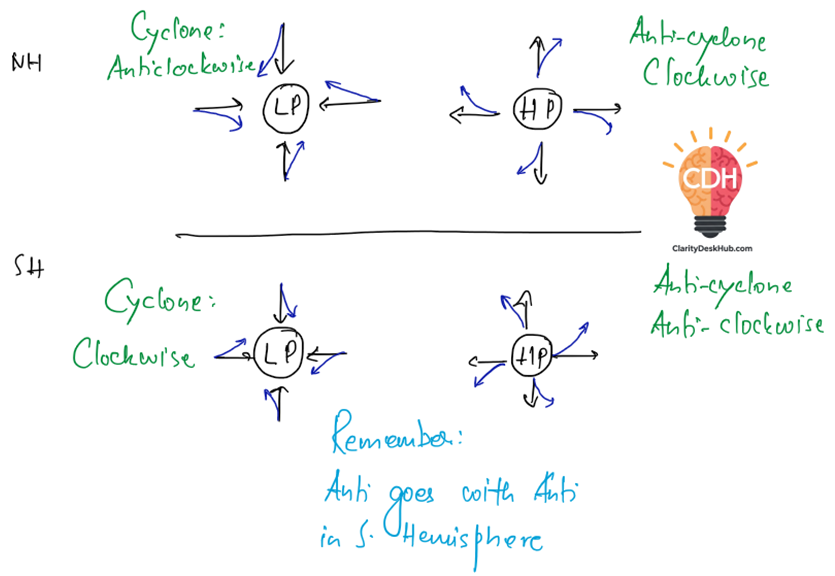
A cyclone is like a giant atmospheric vacuum cleaner, pulling air toward its center😊. It is a low-pressure system, meaning the pressure at its core is lower than its surroundings. Since air naturally moves from high-pressure areas to low-pressure areas, it gets sucked inward. However, due to the Earth’s rotation—the Coriolis Effect—this inward-moving air does not travel in a straight line. Instead, it swirls.
- In the Northern Hemisphere (NH): The air spirals inward in an anticlockwise direction.
- In the Southern Hemisphere (SH): The air spirals inward in a clockwise direction.
This difference happens because the Coriolis force deflects moving objects to the right in the NH and to the left in the SH. Think of it like water swirling down a drain—except on a planetary scale!

What About Anticyclones?
Anticyclones are the opposite of cyclones. They are high-pressure systems, where air descends and spreads outward. Since air is moving away from the center, it follows a pattern opposite to cyclones:
- In the NH: Air moves outward in a clockwise direction.
- In the SH: Air moves outward in an anticlockwise direction.
A useful memory trick is noted in blue: “Anti goes with Anti in the Southern Hemisphere,” meaning anticyclones move anticlockwise there.

Why Does This Matter?
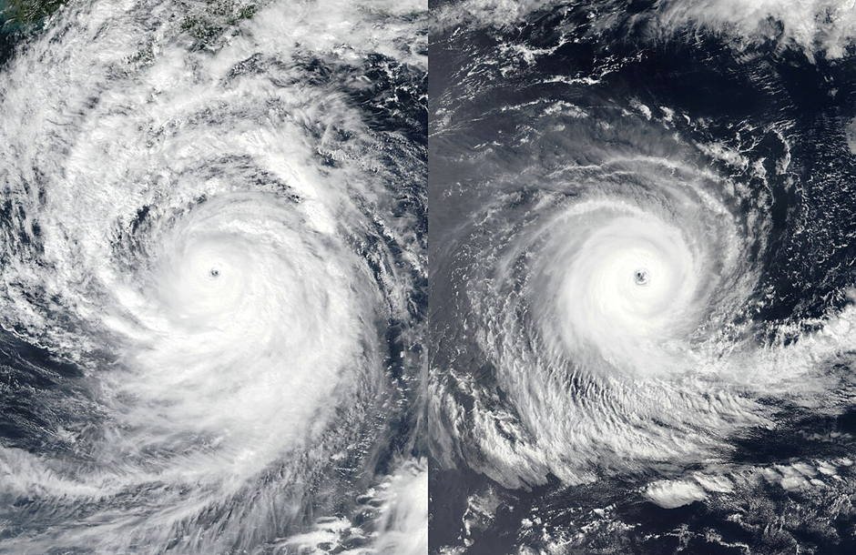
Cyclones bring stormy weather—think of hurricanes, typhoons, and monsoons. Anticyclones, on the other hand, are often associated with clear, stable conditions. Understanding their movement helps meteorologists predict weather patterns and warn communities about approaching storms.
Cyclogenesis – The Birth of Cyclones
The term cyclogenesis simply means:
👉 “The development or intensification of cyclonic circulation in the atmosphere.”
Cyclones don’t just appear suddenly; they are the result of specific mechanisms of genesis. Broadly, three processes of cyclogenesis exist:
1. Convective Cyclogenesis (Tropical Cyclones)
- This is the process we will study in detail in upcoming sections — responsible for tropical cyclone formation.
- Origin: Thermal (heat-driven).
- Mechanism:
- Warm ocean water (> 26–27°C) → moist air rises → condensation releases latent heat → strengthens low pressure.
- Coriolis force deflects winds → spiralling vortex develops.
- If conditions remain favourable, the disturbance → depression → storm → tropical cyclone.
- Examples: Cyclones in the Bay of Bengal, Arabian Sea, Caribbean, Pacific Typhoons.
👉 Key point: Convective cyclogenesis = heat engine fueled by latent heat of condensation.
2. Frontal Cyclogenesis (Extratropical Cyclones)
- This is the process behind temperate/mid-latitude cyclones.
- Origin: Dynamic (caused by air mass contrasts).
- Mechanism:
- At mid-latitudes (~35°–65°), warm tropical air meets cold polar air → strong temperature & density contrast.
- This leads to frontogenesis (formation of warm & cold fronts).
- Wave-like disturbances develop → grow into extratropical cyclones with warm, cold, and occluded fronts.
- Examples: Western Disturbances affecting North-West India; storms across North America & Europe.
👉 Key point: Frontal cyclogenesis = air mass battlefields producing large wave cyclones.
3. Mesocyclones (Tornadoes & Waterspouts)
- Mesocyclone = A rotating updraft of air within a severe thunderstorm.
- These are small-scale, short-lived cyclonic systems, but extremely violent.
- Origin: Warm core, convection-driven.
- Mechanism:
- Thunderstorms produce strong vertical uplift.
- Winds change direction & speed with height (wind shear) → causes rotation.
- This rotating updraft can tighten into a tornado (over land) or waterspout (over sea).
- Examples: Tornado Alley (USA), occasional tornadoes in India (Bengal, Bihar).
👉 Key point: Mesocyclones = mini-cyclones born inside thunderstorms, leading to tornadoes or waterspouts.

One Comment