
West-Flowing Peninsular Rivers
India’s peninsular slope is from west to east, due to the tilting of the Indian plate. Hence, most rivers flow eastward into the Bay of Bengal.
But a few rivers defy this norm and flow westward—into the Arabian Sea. Let’s understand why.
🧭 Why do some rivers flow westward?
🌍 Geological Reason:
- During the formation of the Himalayas, the northern part of the Peninsular block was uplifted and fractured, creating faults (long cracks).
- Some rivers like Narmada and Tapti began flowing through these fault lines — not carving valleys but flowing in already formed linear rift valleys.
- These rift valleys run east-west, but the slope within them is toward the west, guiding the rivers toward the Arabian Sea.
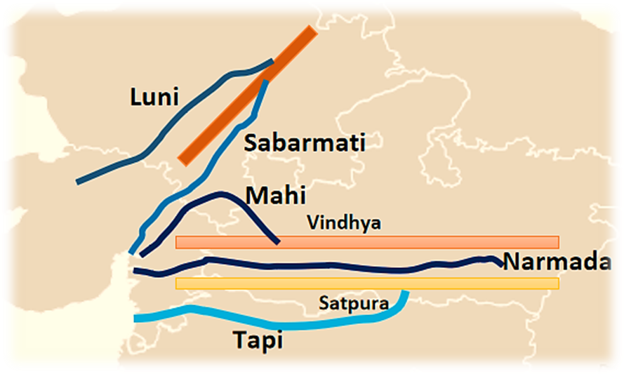
🗺️ Key West-Flowing Rivers
🟦 1. Narmada River – The “Rehwa” of Madhya Pradesh
🟨 2. Tapti (Tapi) River – “Twin Sister of Narmada”
🟥 3. Mahi River – The “Zigzag” River
🟩 4. Sabarmati River – River of Ahmedabad
🏜️ 5. Luni River – Desert’s Disappearing River
We will read in detail about these rivers in detail, but before that let’s understand what an estuary means. This concept will be useful for understanding the West Flowing rivers:
🌀 What is an Estuary?
🧪 Definition: An estuary is a partially enclosed coastal water body where freshwater from rivers mixes with salt water from the sea.
🧠 Key Characteristics:
- 🧭 No delta formation – unlike east-flowing rivers
- 🎣 Fishing hotspots – due to rich biodiversity and plankton
- 🐦 Bird sanctuaries – e.g., Chilika Lake near Mahanadi mouth
- 🌿 Mangroves and salt marshes – prevent erosion
- 🏖️ Great for tourism and ports (e.g. Mormugao, New York Harbour)
💡 Estuaries are among the most productive ecosystems on Earth.
🌍 Examples of Estuary-Based Ports in India:
| Estuary | River | Port |
|---|---|---|
| Zuari & Mandovi | Goa | Mormugao Port |
| Periyar | Kerala | Kochi Port |
| Narmada | Gujarat | Bharuch (minor port) |
✅ Key Takeaways:
- Only west-flowing rivers in rift valleys: Narmada and Tapti
- No deltas – Only estuaries due to lack of silt
- Short coastal rivers in the west have high velocity and create hydropower potential
- Estuaries = ecological + economic hubs (fisheries, ports, tourism)
🟩 Narmada River
Before we dive deep, just remember one simple line —
“The Narmada is not an ordinary river. It is a river with exceptions.”
Why?
- Most rivers in Peninsular India flow eastward into the Bay of Bengal.
- But Narmada flows westward, draining into the Arabian Sea.
- And it doesn’t flow by cutting through land over time like many rivers — it flows through a ready-made path — a rift valley.
Let’s now understand everything, step by step.
Origin and Course
“To understand a river, always begin with its birth.”
- The Narmada River originates from the Maikala Range, near Amarkantak in Madhya Pradesh.
- Elevation at source: Around 1057 meters above sea level — quite high.
- From here, it flows westward, not eastward, which already makes it rare.
🤔 Why westward?
Because it flows through a rift valley – a long, narrow trench-like valley created due to earth’s crust breaking apart (like a crack).
This valley lies between:
- Vindhya Range in the north
- Satpura Range in the south
This is called a graben — a block of land that has sunk between two faults. The Narmada didn’t carve this valley; it found it ready.
🧠 Just like water finds the easiest path, the Narmada took the low-lying rift valley and flowed westward — a classic example of geology guiding geography.
Basin and Path
- The Narmada basin spans across Madhya Pradesh, Maharashtra, Gujarat, and a small part of Chhattisgarh.
- It is bounded by:
- Vindhyas in the north,
- Satpuras in the south,
- Maikala Range in the east,
- Arabian Sea in the west.
- Total length: About 1310 km, from Amarkantak to Gulf of Khambhat (Arabian Sea).
Topography and Urban Centres
- Upper basin: Hilly and forested — not ideal for farming.
- Middle and lower reaches: Broad, flat, and fertile — good for agriculture.
- Only major city in the basin: Jabalpur.
🧠 Remember: Most other major rivers support many big cities along their banks. Narmada doesn’t — again, an exception.
Waterfalls and Scenic Beauty
The Narmada, despite being quiet and narrow compared to rivers like the Ganga, offers some of India’s most beautiful natural landscapes:
🌫️ Dhuandhar Falls:
- Near Jabalpur.
- The river suddenly drops 15 meters into a gorge.
- The mist generated from this fall makes it look like “Dhuan” (smoke).
- The gorge is made of shining white marble — known as the Marble Rocks.
🌊 Sahasradhara Falls:
- Near Maheshwar.
- Smaller, about 8 meters, but picturesque.
The Estuary and Islands
- At its mouth near Gulf of Khambhat, Narmada forms an estuary (not a delta).
- Many small islands are found here.
- Largest one: Aliabet Island.
🧠 Why no delta? Because the river flows over hard rocks, doesn’t carry much silt, and hence doesn’t fan out like Ganga or Mahanadi.
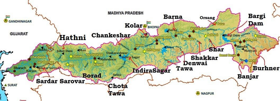
Tributaries – A Lonely Journey
- Because the Narmada flows through a narrow and steep valley, it gets very few tributaries — especially from the right bank.
- Right Bank Tributaries:
- Hathni River (main one)
- Orsang
- Barna
- Kolar
- Left Bank Tributaries:
- These descend from the northern slopes of Satpura Range, joining the Narmada here and there.
- They are seasonal, and not very large.
🧠 Again, the pattern is clear: Unlike rivers like Yamuna or Godavari, which have multiple tributaries, Narmada flows mostly alone.
Hydropower Projects – Harnessing the Current
The Narmada’s rift valley course and narrow channel make it ideal for building hydroelectric dams.
Major projects on Narmada:
- Indira Sagar Dam – One of India’s largest reservoirs
- Sardar Sarovar Project – Famous and controversial (rehabilitation issues)
- Omkareshwar
- Bargi
- Maheshwar
🧠 These dams provide irrigation, drinking water, electricity, and also generate debate over environmental displacement.
🟦 Tapti River
Introduction: A River That Goes Against the Flow
Let’s begin with a simple, relatable idea.
If most students leave the classroom from the front door, but one or two quietly exit through the back — wouldn’t they be noticed?
That’s exactly the case with Tapti and Narmada.
- While most Peninsular rivers flow eastward into the Bay of Bengal, Tapti is among the very few that flow westward, draining into the Arabian Sea.
- That’s why Tapti is often called the ‘Twin’ or ‘Handmaid’ of the Narmada.
So, it shares a similar direction and geological setting, but it’s shorter, has more tributaries, and flows through a different terrain.
Origin and Course
- The Tapti River originates in the Multai Reserve Forest, located in Betul district of Madhya Pradesh.
- Elevation at origin: About 752 meters above sea level.
- It travels a length of 724 km before draining into the Arabian Sea, specifically into the Gulf of Khambhat (also known as Gulf of Cambay).
- Its journey cuts across three major states:
- Madhya Pradesh
- Maharashtra (mainly through Vidarbha and Khandesh)
- Gujarat
The Basin: Shaped by Hills and Fertile Plains
Geographical Boundaries of the Tapti Basin:
- North – Satpura Range
- East – Mahadeo Hills
- South – Ajanta Range and Satmala Hills
- West – Arabian Sea
🧠 In simple terms, the river flows westward, nestled between multiple hill ranges that shape its basin and influence its flow.
Two Distinct Physical Regions:
- Hilly Region:
- Includes Satpura, Mahadeo, Ajanta, Satmala, and Gawilgarh Hills
- Dense forests, rugged terrain
- Plain Region:
- Especially the Khandesh plains in Maharashtra
- Broad, fertile, agriculturally rich
- Known for cotton and food grain cultivation
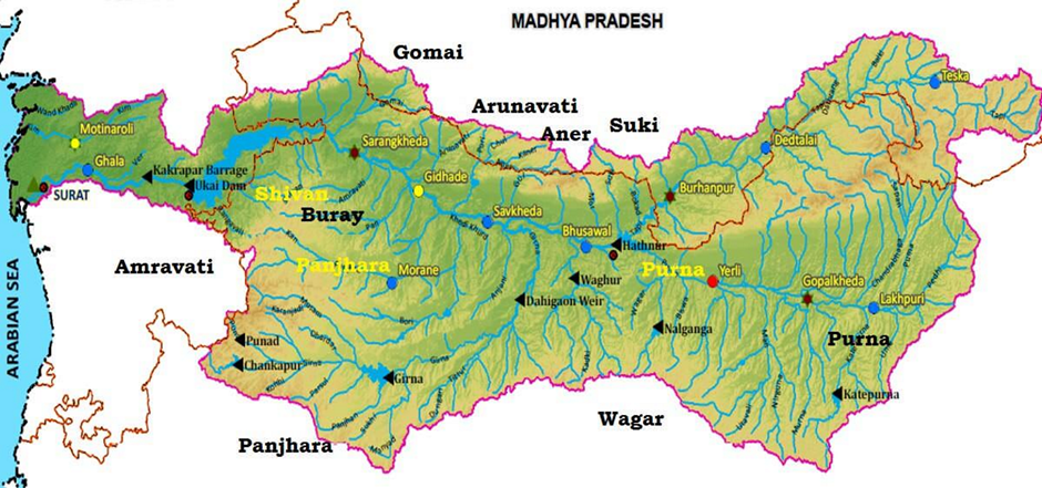
Tributaries of Tapti River
Unlike the Narmada, Tapti has many tributaries, especially from the left bank.
🌊 Right Bank Tributaries (Fewer in number):
- Suki
- Gomai
- Arunavati
- Aner
🌊 Left Bank Tributaries (More in number):
- Vaghur
- Amravati
- Buray
- Panjhra
- Bori
- Girna
- Purna
- Mona
- Sipna
Important Projects on Tapti River
The Tapti River and its tributaries are harnessed for irrigation, flood control, and hydroelectric power.
🌉 Major Projects Include:
🔹 Upper Tapti Project (Maharashtra):
- Hathnur Dam – crucial for irrigation in the upper basin
🔹 Ukai Project (Gujarat):
- Kakrapar Weir
- Ukai Dam – one of Gujarat’s major multipurpose projects
🔹 Girna Project (Maharashtra):
- Girna Dam
- Dahigam Weir
🧠 These projects are essential for agriculture, power generation, and water supply across Maharashtra and Gujarat.
Tapti River and Industry
Where there is water, industry follows — and Tapti is no exception.
⚙️ Key Industrial Zones in Tapti Basin:
- Surat – Textile city of India; relies heavily on Tapti for water
- Nepanagar (MP) – Hosts one of India’s oldest paper and newsprint factories
Tapti’s water supports both traditional textile hubs and modern industry — a lifeline for central and western India’s economy.
🟩 Sabarmati River
Introduction: A River with a Modern Legacy
If a small player becomes the face of a national campaign, it must have something special.
That’s the case with the Sabarmati River.
- It is not very long (only 371 km), not heavily fed by tributaries, and not among the mightiest rivers.
- Yet, it gained prominence because of Mahatma Gandhi’s Sabarmati Ashram on its banks and modern urban planning like the Sabarmati Riverfront project in Ahmedabad.
- It reflects the journey of a modest river that made a national impact.
Origin and Course
Let’s begin with the birth and path of the Sabarmati:
- The Sabarmati River is formed by the confluence of two streams:
- Sabar
- Hathmati
- It originates from the Aravalli Hills, near the village Tepur in Udaipur district, Rajasthan, at an elevation of about 762 meters.
- It travels 371 km before meeting the Arabian Sea, through the Gulf of Khambhat.
Geographical Span and Basin
The Sabarmati basin stretches across two Indian states:
- Rajasthan
- Gujarat
🗺️ Basin Boundaries:
- North and North-East → Aravalli Hills
- West → Rann of Kutch
- South → Gulf of Khambhat
🔺 Basin Shape:
- The basin is roughly triangular.
- Imagine a triangle:
- Base = Sabarmati River
- Apex = Source of Vatrak River (one of its tributaries)
Rainfall and Climate
“When a river runs through uneven rainfall zones, its behavior too becomes unpredictable.”
- Rainfall variation is stark:
- Saurashtra region receives very little rainfall — only a few millimeters.
- Southern part of the basin receives over 100 cm of rainfall.
This makes water management in the Sabarmati basin challenging — balancing scarcity in the west and occasional floods in the south.
Tributaries of the Sabarmati River
Unlike Tapti or Godavari, Sabarmati has fewer tributaries, but they are still significant.
🌊 Left Bank Tributaries:
- Wakal
- Hathmati
- Vatrak
These tributaries mostly come from the eastern and central basin, contributing to the river’s volume.
🌊 Right Bank Tributary:
- Sei River
Just one small tributary from the right bank – a reminder that Sabarmati flows through relatively dry terrain.
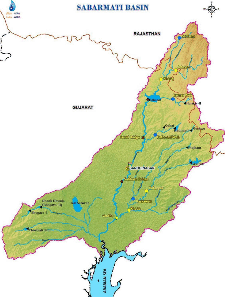
Major Water Projects
Despite its small size, Sabarmati has been harnessed for irrigation and drinking water.
🛠️ Major Dams and Reservoir Projects:
- Dharoi Dam on the Sabarmati
- Hathmati Reservoir
- Meshwo Reservoir
These were mostly built during India’s Five-Year Plan periods, marking a shift toward planned water resource management.
Urban and Industrial Importance
“Wherever rivers go, civilization follows.”
The Sabarmati River Basin is no exception.
🏙️ Major Cities in the Basin:
- Ahmedabad – the largest and most important city
- Gandhinagar – the capital of Gujarat
🏭 Major Industries:
Ahmedabad has evolved into a major industrial hub, with industries like:
- Textiles
- Leather and leather goods
- Plastics and rubber
- Paper and newsprint
- Automobiles, machine tools
- Drugs and pharmaceuticals
⚠️ Environmental Concern:
With industrial growth comes responsibility.
The Sabarmati River, especially in Ahmedabad, faces a risk of water pollution, mostly from industrial waste.
This led to modern efforts like the Sabarmati Riverfront Development, which aims to balance urban life and river conservation.
🧠 Final Thoughts
“Sabarmati is not just a river — it’s a symbol of India’s past, present, and urban future.”
From Gandhiji’s ashram to Ahmedabad’s economic engine, and from dry hills to fertile deltas, Sabarmati may be short, but its significance is long-lasting.
🟦 Mahi River – The Zigzag River of India
Introduction: A River with a Twist (Literally!)
“Most rivers flow in one direction — east or west. But Mahi River is unique. It crosses the Tropic of Cancer twice — once while going north, and again while turning south.”
That’s why Mahi is sometimes called the “River with a zigzag course” or even “the river that flows backward” — not literally, but in terms of its direction.
So, from the very beginning, the Mahi stands out for defying the norm.
Origin and Course
Let’s trace Mahi’s journey step by step:
- It originates from the northern slopes of the Vindhya Range, in Dhar district, Madhya Pradesh, at an elevation of about 500 meters.
- From there, it flows north-westward into Rajasthan, then takes a sharp turn south-westward, entering Gujarat.
- It finally drains into the Arabian Sea through the Gulf of Khambhat.
🔁 Key Highlight:
Mahi crosses the Tropic of Cancer twice, which is rare for any river in the world.
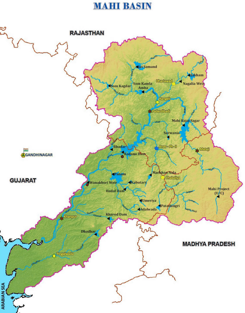
Geographical Extent: The Mahi Basin
The Mahi basin is spread over three states:
- Madhya Pradesh
- Rajasthan
- Gujarat
🗺️ Basin Boundaries:
- North & North-West → Aravalli Hills
- East → Malwa Plateau
- South → Vindhya Range
- West → Gulf of Khambhat (Arabian Sea)
The basin is compact but geologically diverse — with hills, plateaus, and coastal plains all packed into one river system.
Length and Drainage
- Total Length: 583 km
(shorter than Narmada or Tapti, but still important regionally) - Outfall: Arabian Sea via Gulf of Khambhat, like Narmada, Tapti, and Sabarmati.
This makes Mahi one of the few west-flowing rivers in Peninsular India — a group that includes Narmada, Tapti, Sabarmati, and Mahi.
Hydropower and Irrigation Projects
“Even a moderate river, when harnessed well, can light up villages and irrigate fields.”
Mahi may not be the largest, but it’s tapped for hydropower and irrigation:
⚡ Major Projects:
- Mahi Bajaj Sagar Dam – built near Banswara (Rajasthan), a multipurpose dam for power, irrigation, and water storage.
- Kadana Dam – located in Gujarat, it helps regulate flow and generate power downstream.
These dams are crucial for semi-arid regions of Rajasthan and Gujarat that often face water stress.
Urban and Industrial Presence
Unlike the Sabarmati or Tapti basins, the Mahi River basin is sparsely urbanized.
Key Urban Centre:
- Vadodara (in Gujarat) is the only major city along the basin.
Beyond Vadodara, the basin is primarily rural, focused on agriculture, not industry.
Hence, industrialization along Mahi is minimal, and so are the concerns of water pollution — at least for now.
🧠 Final Thoughts
- It’s not long or mighty, but geographically fascinating.
- It helps irrigate dry regions of Rajasthan and Gujarat.
- It crosses the Tropic of Cancer twice, adding a unique geographical distinction.
.
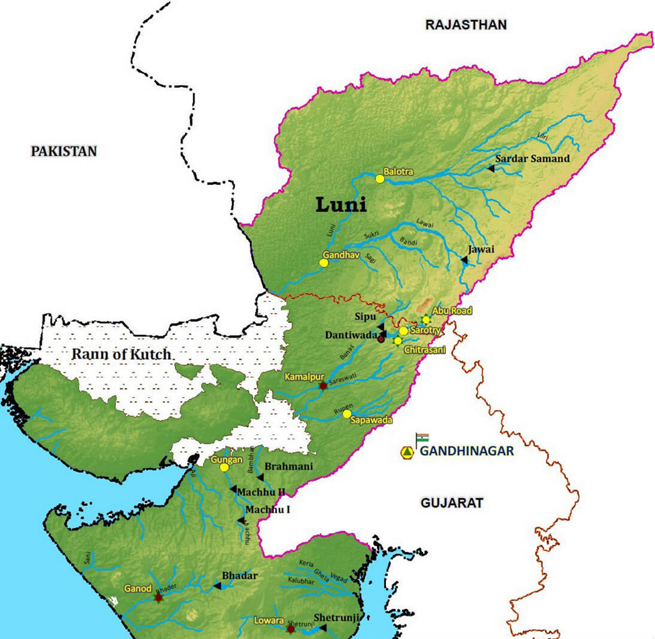
🟫 Luni River – The Disappearing River of the Desert
Introduction: A River in the Desert
“A river in the desert is like a whisper in a storm — rare, surprising, and short-lived.”
In the arid lands of western Rajasthan, where sand rules the landscape, the Luni River becomes a lifeline — though short-lived and salty.
- Also known as the Salt River or “Lonari” in Sanskrit.
- Named “Luni” because its water turns brackish (salty) after a certain point — specifically below Balotra, a town in Rajasthan.
So unlike the Ganga or Narmada, which give fresh drinking water, Luni carries water that cannot be consumed, especially in its lower course. But still, it supports agriculture in its own way.
Origin and Course
Let’s follow Luni’s journey:
- Origin: It rises from the western slopes of the Aravalli Hills, near Ajmer, at an elevation of 772 meters.
- Direction: Flows southwestward through Rajasthan.
- Total Length: 511 kilometers — not very long, but significant for its region.
- Outfall: Doesn’t meet the sea like most rivers — instead, it “disappears” into the marshes of the Rann of Kachchh.
🧂 Peculiar Ending:
“Luni doesn’t end, it fades away…”
It’s an endorheic river — meaning it does not drain into the sea but evaporates or seeps into the land, a common trait in desert rivers.
Significance of Luni Basin
- The Luni Basin is the only river basin of any importance in western Rajasthan — a region otherwise dominated by deserts.
- It supports agriculture in Pali, Jodhpur, Barmer, Jalore, and parts of Nagaur and Jaisalmer.
- Its flow is mostly seasonal, based on the southwest monsoon, which brings short but intense rains.
A River with Unique Geography
Here’s where it gets interesting:
🌊 Unusual Flow Dynamics:
- Banks: Made of soft, erodible soil.
- Riverbed: Composed of sand, which doesn’t easily get dug deeper.
Now imagine this:
“Most rivers cut deeper channels with every flood, like a knife slicing into cake. But Luni behaves differently — it spreads wide rather than going deep.”
⏱️ Flash Flood Behavior:
- When rain comes, flash floods develop rapidly.
- But because the floodwater doesn’t stay long, there’s no time to carve out the bed.
- So the river widens, not deepens — an opposite behavior from Himalayan rivers.
This is a perfect example of geology influencing hydrology.
Salinity — A Double-Edged Sword
- In its upper course, Luni’s water is somewhat fresh and used for irrigation.
- But as it flows westward, the water picks up salts from the soil, turning brackish.
- This makes it unsuitable for drinking and limits the kind of crops that can be grown.
Yet, local communities have adapted — using Luni’s water for salt-tolerant crops like barley, pulses, and oilseeds.
Luni in Context: A River of the Thar
“In the vast dryness of the Thar Desert, Luni is not just a river. It’s hope, however fleeting.”
While not majestic like the Brahmaputra or the Ganga, Luni is a desert river — and desert rivers are rare and valuable.
- It symbolizes temporary abundance in a land of scarcity.
- Its basin supports small-scale agriculture and seasonal livelihoods.
- And its peculiar nature makes it a fascinating case in Indian physical geography.
🧠 Final Thought
“Luni is a teacher — it tells us how life finds a way, even in deserts.”
Despite being seasonal, brackish, and ephemeral, Luni nourishes millions across Rajasthan. It reminds us that geographical limitations don’t always stop human resilience — they simply shape it differently 😊
🌊 West-Flowing Rivers of the Sahyadris (Western Ghats)
Introduction – The Sahyadri’s Gift to the West Coast
“If the Himalayas are the crown of India, the Western Ghats are its spine — and from this spine, hundreds of sparkling streams tumble down like silver threads 😊”
The Western Ghats, also known as the Sahyadri Hills, are a chain of mountains that run parallel to the western coast of India — stretching from Maharashtra down to Kerala. They are not only known for their biodiversity, but also for being the birthplace of countless small rivers.
- More than 600 small rivers and streams originate from the western slopes of these hills.
- These rivers flow westwards, directly into the Arabian Sea.
- Though most of these rivers are short and seasonal, they play a vital role in shaping the geography, ecology, and human settlements of the Konkan, Goa, Karnataka, and Kerala coasts.
Why So Many Rivers?
The answer lies in two major factors:
🟠 Topography – The Steep Western Slope
- The Western Ghats have a steep western face and a gentler eastern slope.
- This steepness causes rivers to rush rapidly westward, covering short distances but with high velocity.
- Since the fall is sharp, many rivers form waterfalls.
🟢 Rainfall – The Blessing of the Monsoon
- The western face of the Ghats is directly hit by the Southwest Monsoon winds.
- This area receives very heavy rainfall, sometimes more than 300 cm annually.
- This abundant rainfall ensures that even small hill streams remain active during the monsoon season.
“The monsoon clouds, blocked by the Ghats, have no choice but to pour everything — like a guest caught without an umbrella.”
Nature of These Rivers
Let’s understand the key characteristics:
| Feature | Description |
|---|---|
| Length | Mostly short (due to short distance to the sea) |
| Flow | Swift and seasonal |
| Gradient | Very steep, causing rapid flow |
| Source | Mostly in Western Ghats |
| Destination | Arabian Sea |
| Waterfalls | Common due to steep descent |
Jog Falls
“Among all these west-flowing rivers, one creates magic — the Jog Falls 😊.”
- Formed by the Sharavati River in Karnataka.
- The Jog Falls (also known as Gersoppa Falls) has a drop of 289 meters.
- It is one of the tallest waterfalls in India.
- The Sharavati plunges straight off the cliff in four distinct streams — named Raja, Roarer, Rocket, and Rani — each with its unique flow style.
It’s not just a geographical feature — it’s an aesthetic wonder, often used in tourism, literature, and art to symbolize nature’s raw power.
Ecological and Human Importance
These rivers, though short, have multiple roles:
- Support agriculture in narrow coastal plains.
- Maintain freshwater balance in backwaters and estuaries, especially in Kerala.
- Power small hydroelectric projects, especially in Karnataka and Goa.
- Feed the monsoon-based agriculture, including rice cultivation.
- Maintain biodiversity in the Western Ghats, which is a UNESCO World Heritage Site.
🧠 Final Thought
“In geography, we often admire mighty rivers like the Ganga or Brahmaputra. But the Sahyadri’s west-flowing streams teach us that even short journeys can be powerful.”
Though these rivers are small, they sustain millions of people, forests, farms, and cultures along the western coast. Their energy, velocity, and seasonal rhythm make them a distinct category in Indian river systems — worthy of respect, study, and preservation.