
A-Tropical Humid Climate
Introduction – Where do we find Tropical Humid Climates?
When we talk about tropical humid climates, immediately two keywords should come to our mind — “tropics” and “humidity.”
- The tropics lie between the Tropic of Cancer (23½° N) and the Tropic of Capricorn (23½° S).
- In this region, the sun is almost overhead throughout the year.
- This is also the zone where the Inter Tropical Convergence Zone (ITCZ) dominates — meaning winds from both hemispheres converge, forcing the hot moist air upwards and causing heavy rainfall.
So the overall character becomes: hot + humid + high rainfall + low annual temperature range.
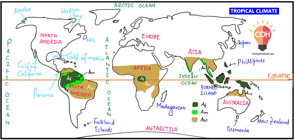
Now, Köppen divided the tropical climates into three types:
- Af – Tropical Wet Climate (no dry season)
- Am – Tropical Monsoon Climate
- Aw – Tropical Wet and Dry Climate (Savanna)
First, we will first focus on Af (Tropical Wet / Equatorial Rainforest Climate).
Af (Tropical Wet / Equatorial Rainforest Climate).
Distribution – Where do we see Af Climate?
- It is confined to regions close to the equator (about 5° N to 5° S).
- Why only here? Because here the Coriolis force is very weak → no tropical cyclones, only uniform rising of moist air.
- Major regions:
- Amazon Basin in South America
- Congo Basin in Africa
- Malaysia, Indonesia, Papua New Guinea in Southeast Asia
So, if you think of equatorial climate, always imagine dense evergreen forests like the Amazon or Congo.
Climate Characteristics
(a) Temperature
- Extremely uniform throughout the year → no winter.
- Annual average: around 27°C.
- Both annual range (difference between hottest and coldest months) and diurnal range (difference between day and night) are very small.
- Why? Because of cloudiness, high humidity, and daily sea–land breezes which moderate extremes.
👉 In short: Climate is equable.
(b) Rainfall
- Average annual rainfall: 150–300 cm, distributed throughout the year.
- Almost every afternoon, thunderstorms occur due to convectional rainfall (Cumulonimbus clouds).
- There is no dry season. Every month gets rainfall more than 6 cm.
- But still, there are two rainfall peaks (April & October) around the Equinoxes — when the sun (and ITCZ) passes directly overhead.
- Lowest rainfall is in June and December (solstices).
👉 This double rainfall maximum is a unique feature of equatorial climate. No other climate has this.
Equatorial Vegetation
Now, because of constant heat + abundant rainfall, nature produces the most luxuriant vegetation on earth: Tropical Rainforests (Selvas in Amazon).
Features of Equatorial Rainforests:
- Multilayered structure:
- Tallest trees (~50 m) form a canopy.
- Below them → medium trees.
- At the bottom → ferns, shrubs, shade-tolerant plants.
- Because sunlight hardly reaches the ground, undergrowth is sparse.
- Epiphytes: Plants that grow on trees to reach sunlight (e.g., orchids, mosses).
- Evergreen hardwoods: Mahogany, ebony, rosewood, dyewoods.
- Mangroves: In swampy coastal regions.
Why despite huge forests, timber is not exploited commercially?
- Because trees grow in mixed stands, not in pure blocks like pine or oak in temperate regions.
- Hardwood trees are too heavy to float on rivers, so transportation is costly.
- Hence paradox: Equatorial countries → dense forests but net timber importers.
Human Life and Economy
(a) Traditional Life
- Population is sparse.
- Many indigenous tribes survive as hunter-gatherers or by shifting cultivation (slash-and-burn).
(b) Early Commercial Activities
- Amazon tribes: collected wild rubber.
- Congo Pygmies: gathered nuts.
- Malaysia’s Orang Asli: made cane products.
(c) Plantations (after Europeans came)
- Huge forests cleared → large-scale plantations.
- Major crops:
- Rubber (Malaysia, Indonesia)
- Cocoa (Ghana, Nigeria)
- Palm oil (Indonesia, West Africa)
- Sugarcane & Coffee (Brazil)
- Coconuts, tea, tobacco, spices
👉 Plantation crops are tropical cash crops, grown for industrial demand in the West.
Problems and Constraints
(a) Health Issues
- High humidity + heat → diseases like malaria, yellow fever.
- Insects, pests spread diseases and damage crops.
(b) Jungle as a Barrier
- Road/rail construction faces snakes, insects, wild animals and diseases.
- Maintenance costs are high.
(c) Livestock Limitation
- No meadow grass → only tall coarse grasses, unfit for cattle.
- In Africa, tsetse fly spreads ngana disease → prevents cattle rearing.
(d) Resource Curse
- Region is rich in gold, copper, cobalt, oil, diamonds.
- But mining damages rainforest ecology.
- Examples:
- Gold mining in Brazilian Amazon
- Cobalt mining in Congo
- Oil in Ecuador, Venezuela, Peru
Summary Thought
So, the equatorial climate appears to be a “paradise” of nature — uniform warmth, abundant rain, thick forests, biodiversity. But for human development, it has been more of a challenge: health hazards, transportation problems, agricultural limitations. That’s why, despite its riches, the equatorial belt is economically less developed compared to temperate regions.
👉 This paradox — rich natural resources, yet poor human development — is a recurring theme in world geography and very important for UPSC answers.
Excellent! Let’s now move from the Af – Equatorial Wet Climate to the second important type of Tropical Humid Climate under Köppen’s system: Am – Tropical Monsoon Climate.
Am – Tropical Monsoon Climate
Introduction – What makes Monsoon Climate different?
The equatorial climate (Af) is uniform: rain every month, no dry season. But the monsoon climate (Am) is completely different.
👉 The hallmark of monsoon climate is the seasonal reversal of winds, leading to distinct wet and dry seasons.
- In summer → On-shore winds (sea → land) bring heavy rain.
- In winter → Off-shore winds (land → sea) bring dryness.
Thus, unlike the equatorial climate, here people experience 3 well-marked seasons:
- Summer (Hot and dry)
- Rainy season (South-West Monsoon, heavy rainfall)
- Winter (Cool and dry)
Floods in rainy season, droughts in dry season — both are common.
Distribution – Where do we find this climate?
- Latitudinal range: 5° to 30° N and S of equator.
- Best developed in:
- Indian subcontinent (classic monsoon land)
- Myanmar, Thailand, Laos, Cambodia, Vietnam, South China
- Northern Australia
- Beyond this zone, in coastal margins, it merges into Tropical Marine Climate.
Temperature Characteristics
- Monthly means: above 18°C (since it is tropical).
- Summer: 30–45°C (mean ~30°C, peaks up to 44°C in Sindh and peninsular India).
- Winter: 15–30°C (mean ~20–25°C).
👉 Thus, annual range is larger than equatorial climate because of the seasonal rhythm.
Rainfall Characteristics
- Annual mean rainfall: 200–250 cm, but in some places 350 cm.
- Extreme examples: Cherrapunji & Mawsynram in Meghalaya (wettest places on Earth, ~1150 cm per year).
- Why so much rain?
- They lie on the windward side of Meghalaya hills (Orographic rainfall).
- Surrounded by hills → funneling effect concentrates clouds.
- Why so much rain?
👉 Rain is concentrated mainly in the rainy season (June–Sept), unlike the equatorial regions where it rains all year.
Seasonal Rhythm
(a) Cool Dry Season (Oct–Feb)
- Dominated by North-East Monsoon (off-shore dry winds).
- Most of India remains dry.
- Exceptions:
- Punjab → gets winter rain from Western Disturbances (frontal cyclones from Mediterranean). Important for wheat.
- Tamil Nadu coast → gets rain because NE monsoon picks up moisture from Bay of Bengal.
(b) Hot Dry Season (March–mid-June)
- Sun shifts northward, heating land.
- Temperatures: 35–44°C common.
- Loo winds (hot, dry winds) blow in northern India.
- Occasional hailstorms in April–May.
- Very little rain.
(c) Rainy Season (Mid-June–Sept)
- The South-West Monsoon bursts with full force.
- Torrential downpours occur — bulk of the annual rainfall concentrated here.
- Crops, rivers, agriculture — all depend on this rainfall.
(d) Retreating Monsoon (Sept–Oct)
- Monsoon weakens and withdraws southward.
- Skies clear, humidity drops.
- North-East Monsoon sets in again.
Tropical Marine Climate (a Transition Zone)
Outside the core monsoon zone, coastal regions experience a Tropical Marine Climate.
- Rainfall is more evenly distributed (not so seasonal).
- Influenced by trade winds all year.
- Found in: Central America, West Indies, N.E. Australia, Philippines, East Africa, Madagascar, Guinea Coast, Eastern Brazil.
- But these regions are prone to tropical cyclones (typhoons, hurricanes).
Vegetation – Tropical Monsoon Forests
- Also called Tropical Deciduous Forests.
- Key difference from equatorial forests: trees are deciduous → shed leaves in dry season to conserve water.
- Forests are more open, less luxuriant, fewer species compared to equatorial jungle.
- Luxuriant vegetation refers to dense, lush, multi-layered plant growth with rich biodiversity, sustained by abundant rainfall and favorable climatic conditions.
- Where rainfall is high → luxuriant forests (e.g., southern Myanmar, coastal India).
- Where rainfall decreases → thorny scrubland or savanna (e.g., Deccan Plateau, rain-shadow of Western Ghats).
- In driest areas (Telangana, Vidarbha) → semi-desert conditions.
Important timber species: Teak (Myanmar’s pride), Sal, Neem, Acacia, Mango, Eucalyptus, Bamboo thickets.
👉 Teak is highly valued because of strength, durability, resistance to fungus.
But teak logs are so heavy they don’t float → hence special methods like “poisoning” the tree years before felling (to dry and lighten the wood).
Population and Economy
(a) Agriculture
- Monsoon lands are densely populated (India, China, SE Asia).
- Farming is the dominant occupation.
- Rice is the staple crop (needs standing water, heavy rain).
- Other food crops: maize, millet, sorghum, wheat, gram, beans.
- Cash crops: sugarcane, jute, cotton, spices.
(b) Plantations in Highlands
- Europeans developed plantations in upland slopes with moderate climate.
- Tea → India (Assam, Darjeeling), Sri Lanka, Java, China (for local use).
- Coffee → Brazil (world leader), Central America, India, Java.
(c) Shifting Cultivation (Slash-and-Burn)
- Common in tribal belts, especially forested monsoon regions.
- Soil fertility is poor (tropical leaching), so land is cultivated for a few years, then abandoned.
- Known by different names:
- Jhum – NE India
- Taungya – Burma
- Tamrai – Thailand
- Caingin – Philippines
- Chena – Sri Lanka
- Milpa – Africa & Central America
Summary Thought
So, if we compare Af (Equatorial Wet) and Am (Tropical Monsoon):
- Equatorial: uniform rain, no dry season, evergreen jungle, sparse population, shifting cultivation.
- Monsoon: distinct wet/dry seasons, deciduous forests, dense population, agriculture-based economy, rice + cash crops, timber exploitation.
👉 In UPSC answers, always highlight:
- Monsoon = rhythm of life in Indian subcontinent.
- Its dual nature: a blessing (agriculture, forests) and a curse (floods, droughts).
Perfect, now we move to the third and final sub-type of Tropical Humid Climate in Köppen’s classification — the Savanna or Tropical Wet and Dry Climate (Aw).
This is an extremely important topic for UPSC because it is a transitional climate between the Equatorial Rainforest (Af) and the Hot Desert (BWh). Let’s try to understand this part:
Savanna or Tropical Wet and Dry Climate (Aw)
Introduction – Nature of Savanna Climate
- Symbol: Aw → A = Tropical; w = dry winter.
- The defining feature: alternate wet and dry seasons.
- Unlike the equatorial climate (rain all year) or monsoon climate (seasonal burst of rains), here rainfall is restricted to the summer months only.
- Dry winters are long and harsh, often leading to droughts; summers are wet but can bring floods.
👉 So, Savanna is a land of contrasts:
- Green pastures in rainy season → dry, fire-prone landscape in winter.
Distribution – Where is Savanna found?
Savanna is best developed in Sudan region of Africa, hence also called Sudan Climate.
Being transitional, it lies between equatorial forests and hot deserts.
Major regions:
- Africa:
- Belt of West African Sudan → curves down into East Africa (Kenya, Tanzania, Uganda) → extends to Southern Africa (north of Tropic of Capricorn).
- This is the classic Savanna belt.
- South America:
- Llanos (Orinoco Basin, Venezuela & Colombia).
- Campos (Brazilian Highlands).
- Australia:
- Northern Australia (south of monsoon strip), especially Queensland savannas.
- India:
- Parts of North Karnataka, South Maharashtra, Telangana → semi-arid to savanna features (later modified by irrigation projects).
Climate Characteristics
(a) Rainfall
- Annual rainfall: 80–160 cm (much less than monsoon).
- Seasonal rhythm:
- Northern Hemisphere Savanna → rains May–Sept.
- Southern Hemisphere Savanna → rains Oct–Mar.
- Dry winters are long, often leading to drought conditions.
- Rainfall decreases with distance from equator.
(b) Temperature
- Mean annual temperature: above 18°C.
- Range: 20°C–32°C in lowlands.
- Hottest period: just before rains begin (April in N. Hemisphere; Oct in S. Hemisphere).
- Characteristic feature: Large diurnal range → very hot days, cold nights.
(c) Winds
- Controlled by trade winds (easterlies).
- Bring moisture to eastern coastal areas, but by the time they reach interiors or west coast, they become dry.
- In West Africa, dry dust-laden Harmattan winds blow from the Sahara towards the Guinea coast during winter.
👉 Reason for alternating wet/dry seasons:
- Summer → onshore moist trades (ITCZ overhead) → rain.
- Winter → offshore trades → dryness.
Vegetation – Savanna Landscape
- Typical vegetation: “tall grass + scattered trees.”
- Grass: coarse, tall (6–12 ft); elephant grass can reach 15 ft.
- Trees: deciduous (shed leaves in dry season), e.g., acacias.
- Trees have:
- Broad trunks to store water.
- Umbrella-shaped tops to reduce wind exposure.
- In drier margins → vegetation thins into thorny scrub or semi-arid bushland.
👉 This is the classic “parkland” landscape — grasslands dotted with trees.
Animal Life – “Big Game Country”
- Savanna supports the richest animal diversity after equatorial forests.
- Famous for wildlife migration in search of water and grazing.
- Home to lions, leopards, cheetahs, giraffes, zebras, elephants, rhinos, buffaloes, antelopes.
- That’s why most National Geographic & Animal Planet documentaries are shot here.
- Unfortunately, this is also the world’s biggest hunting ground (both legal & illegal).
Human Life and Economy
(a) Tribes
- Masai (East Africa): Nomadic pastoralists.
- Keep cattle for milk (not slaughtered).
- Hausa (Nigeria): Settled cultivators.
- Practice permanent agriculture (not shifting cultivation).
- Many tribal areas taken over by European settlers → plantation farming (coffee, cotton, tea).
(b) Farming Challenges
- Soils: Lateritic, infertile (nutrients leached during rains; water evaporates in dry season).
- Rainfall is unreliable → frequent droughts.
- Political instability in many African states worsens infrastructure development.
(c) Crops
- Savanna has potential for plantation agriculture:
- Cotton, cane sugar, coffee, oil palm, groundnuts, fruits.
- Examples:
- Queensland (Australia): sugarcane, cattle ranching.
- West Africa: groundnuts, cocoa, oil palm.
- Brazil: Campos used for coffee & cattle.
(d) Cattle Rearing
- Savanna is often called “natural cattle country.”
- But quality of grass is poor compared to temperate grasslands.
- Local cattle breeds are also less productive (low meat/milk yield).
- Thus, large-scale ranching is limited.
- Exception: Queensland (Australia) has developed modern ranching → exports meat & dairy.
Summary Thought
The Savanna (Aw) climate represents the great “middle ground” of the tropics.
- It is not as lush as the rainforest (Af),
- nor as productive as the monsoon lands (Am),
- but it supports some of the richest biodiversity on Earth and is home to iconic human adaptations like the Masai pastoralism.
👉 From the UPSC perspective, always remember:
- Equatorial (Af): Evergreen rainforest → hunter-gatherers & plantations.
- Monsoon (Am): Deciduous forests → rice farming, dense population.
- Savanna (Aw): Grasslands + scattered trees → pastoralism, lateritic soils, wildlife diversity.
One Comment