
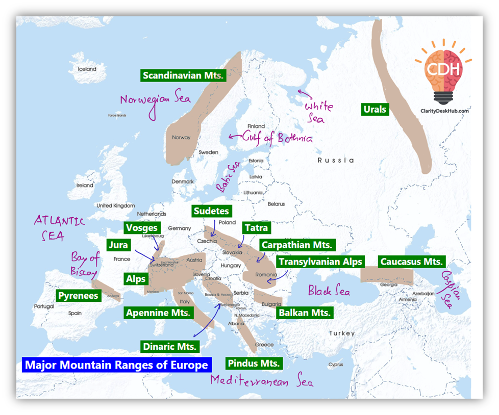
Major Mountain Ranges of Europe
Let’s begin with a basic analogy:
Just as a human skeleton gives structure and form to the body, mountain ranges shape the geography of continents. In Europe, these mountains are not just physical features—they’re climatic dividers, cultural boundaries, biodiversity zones, and even geopolitical lines.
We will study the major mountain ranges one-by-one, moving from north and east, then central and south, and finally the boundary with Asia.
🏔️ Ural Mountains (~2,500 km)
📍 Location:
- Runs north to south through western Russia.
- Acts as the conventional boundary between Europe and Asia.
📖 Key Features:
- One of the oldest mountain ranges on Earth (formed ~250–300 million years ago).
- Formed by a continental collision—a classic case of Uralian orogeny.
- Cuts across various landscapes:
- Arctic tundra in the north
- Forests and semi-deserts in the south
- Extends into northwestern Kazakhstan through Mughalzhar Hills, dividing Caspian and Aral Sea basins.
⛰️ Highest Peak:
- Mount Narodnaya – 1,895 m
🌊 Drainage:
- Rivers from this range flow into:
- Arctic Ocean
- Caspian Sea
🔍 Why is it important?
This is a continental divider, an ancient orogen, and geologically part of the Eurasian tectonic history.
🏔️ Scandinavian Mountains (~1,762 km)
📍 Location:
- Runs through the Scandinavian Peninsula, mainly Norway and Sweden.
- In the north, it forms the Norway–Sweden border.
📖 Key Features:
- The western slopes drop steeply into the Norwegian Sea, forming fjords—long, narrow sea inlets with steep cliffs.
- Associated with the Scandinavian Montane Birch Forest (unique ecozone).
⛰️ Highest Peak:
- Galdhøpiggen – 2,469 m (in southern Norway)
🔍 Why is it important?
Because it creates dramatic fjords, influences Nordic climate, and marks a natural boundary.
🏔️ Carpathian Mountains (~1,500 km)
📍 Location:
- Curves across Central and Eastern Europe.
- Present in countries like Slovakia, Poland, Romania, Ukraine, Serbia, and Hungary.
📖 Key Features:
- Third-longest Mountain system in Europe.
- Tatra Mountains: Highest subrange in Slovakia and Poland.
- Rivers draining the Carpathians mostly flow into the Black Sea.
Subdivisions:
| Region | Countries |
| Western Carpathians | Austria, Czech Republic, Slovakia, Poland, Hungary |
| Eastern Carpathians | Romania, Ukraine, eastern Slovakia |
| Southern Carpathians | Romania, eastern Serbia |
⛰️ Highest Peak:
- Gerlachovský štít – 2,541 m (Slovakia)
🔍 Why is it important?
It’s a biodiversity hotspot, divides climatic zones, and controls the hydrology of Eastern Europe.
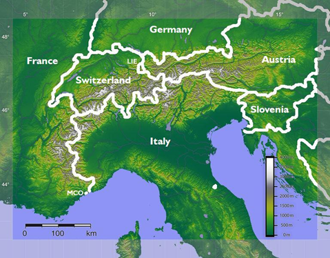
🏔️ Alps (~1,200 km)
📍 Location:
- Spread across eight Alpine countries:
France, Switzerland, Monaco, Italy, Liechtenstein, Austria, Germany, Slovenia
📖 Key Features:
- Highest mountain range system entirely within Europe.
- Contains over 100 peaks above 4,000 metres—referred to as “four-thousanders“.
- Major rivers originate here:
- Rhine, Rhône, Inn, Po
⛰️ Highest Peak:
- Mont Blanc – 4,808 m (on French–Italian border)
🌬️ Important Winds:
- Foehn: Warm, dry wind on the leeward side.
➤ Melts snow, aids grazing and grape cultivation. - Mistral: Cold, fast wind blowing from Alps to Mediterranean via Rhone Valley.
➤ Causes blizzards in southern France.
🔍 Why is it important?
Alps are Europe’s climatic wall, a river source, and a tourism and viticulture zone.
🏔️ Caucasus Mountains (~1,100 km)
📍 Location:
- Lies between the Black Sea and Caspian Sea.
- Spreads across Russia (Europe) and Georgia, Azerbaijan, Armenia (Asia).
📖 Key Features:
- Divided into:
- Greater Caucasus (north):
➤ Acts as natural boundary between Europe and Asia - Lesser Caucasus (south):
➤ Geographically in Asia, spans into Turkey and Iran
- Greater Caucasus (north):
⛰️ Highest Peak:
- Mount Elbrus – 5,642 m (in Greater Caucasus, Russia)
➤ This is the highest mountain in Europe (based on the conventional boundary).
🔍 Why is it important?
It forms a continent-dividing wall, is home to Europe’s highest point, and sits in a geopolitical hotspot.
🧠 Summary Table: Major European Mountains
| Range | Approx. Length | Highest Peak (m) | Countries Covered | Key Feature |
| Ural Mountains | ~2,500 km | Mount Narodnaya (1,895 m) | Russia, Kazakhstan | Boundary of Europe and Asia |
| Scandinavian Mountains | ~1,762 km | Galdhøpiggen (2,469 m) | Norway, Sweden | Fjords, Birch forests |
| Carpathians | ~1,500 km | Gerlachovský štít (2,541 m) | Slovakia, Romania, etc. | Curved mountain arc |
| Alps | ~1,200 km | Mont Blanc (4,808 m) | 8 countries | Highest entirely in Europe |
| Caucasus | ~1,100 km | Mount Elbrus (5,642 m) | Russia, Georgia, etc. | Highest in Europe, Asia-Europe border |
3 Comments