
Walker Circulation and El Niño-Southern Oscillation (ENSO)
Let’s hypothetically imagine that you are standing on the vast Pacific Ocean, feeling the trade winds brush against your face. To your left lies South America, with its cool waters and thriving fisheries, and to your right, the warm waters of Indonesia, pulsing with energy. But what if this balance shifts? That’s exactly what we explore in Walker Circulation and ENSO.
Walker Circulation: The Normal State of Affairs
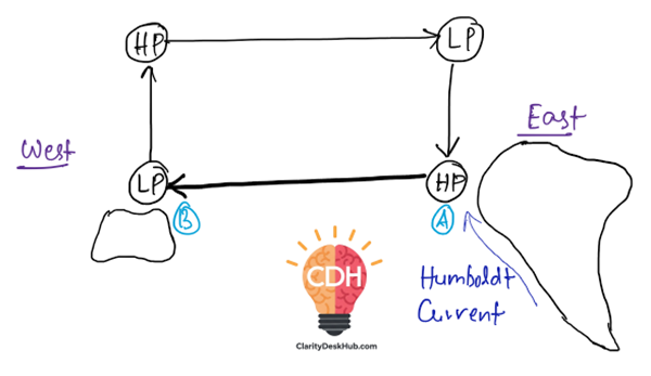
Apart from the well-known Hadley Circulation, which moves air between the equator and the poles, there is another key circulation—Walker Circulation, which moves air horizontally (east to west) along the equator.
- Under normal conditions, the equatorial Pacific Ocean has a pressure gradient:
- High pressure dominates the eastern Pacific (near Peru and Ecuador).
- Low pressure prevails over the western Pacific (near Indonesia and Australia).
- Why does this happen?
- In the East (South America): Cold oceanic water rises from the deep (a process called upwelling), cooling the air above and making it denser—leading to high pressure.
- In the West (Indonesia, Australia): The warm ocean heats the air, causing it to rise—creating low pressure.
- How does the circulation form?
- Surface trade winds blow from east to west, pushing warm waters toward Indonesia.
- The air rises in the western Pacific, moves eastward at higher altitudes, and sinks over the eastern Pacific—completing a convective loop known as Walker Circulation.
This system ensures stable weather:
- The eastern Pacific stays dry, and upwelling near Peru keeps the ocean rich in nutrients, supporting thriving fisheries.
- The western Pacific experiences moist, rising air, leading to heavy rainfall over Indonesia and Australia.
Southern Oscillation: The Periodic Shift
Like a pendulum, this pressure balance does not stay constant. Every 2-3 years, it reverses—high pressure forms in the west, and low pressure develops in the east. This reversal is called the Southern Oscillation.
Diagram of Walker Circulation:
El Niño
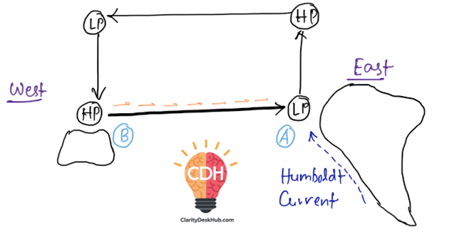
Now, imagine the trade winds suddenly weakening around October-November. What happens next?
- The normal circulation pattern collapses.
- The Humboldt Current (cold ocean current near Peru) weakens.
- Cold upwelling near Peru stops, and warm water spreads eastward across the Pacific.
- Consequences of El Niño:
- Peruvian coast:
- Heavy rainfall, leading to floods.
- Coconut farming thrives due to increased rainfall.
- Collapse of fisheries due to lack of nutrient-rich waters.
- Guinea disease outbreak (linked to poor water conditions).
- India & Asia:
- Weaker monsoon, leading to droughts.
- Crop failures affect agriculture and economy.
- Indonesia, Australia, and Africa:
- Severe droughts, wildfires, and crop failures.
- USA (California):
- Heavy rainfall, causing landslides and floods.
- Peruvian coast:
Thus, El Niño disrupts global weather, affecting farming, fisheries, and even economies worldwide.
Diagram of El-Nino
Key Reasons Behind El Niño:
- Weakening of Trade Winds
- This can happen due to sunspot activity or other atmospheric factors.
- Without strong trade winds, warm water is not pushed westward as usual.
- Weakening of the Humboldt Current
- Normally, the Humboldt Current brings cold, nutrient-rich water up along the coast of South America (A).
- When trade winds weaken, less upwelling occurs, reducing the strength of the current.
- Southward Shift of the Counter Equatorial Current
- The Counter Equatorial Current (a warm ocean current) moves southward, bringing more warm water to the eastern Pacific.
- This leads to the formation of low pressure (LP) at A instead of B.
ENSO – A Cycle of Chaos and Order
El Niño is just one phase of a larger cycle called El Niño-Southern Oscillation (ENSO). After El Niño, the system often overcompensates, leading to La Niña—a phase where trade winds become even stronger, intensifying the normal Walker Circulation and bringing opposite effects (excessive monsoon in India, stronger droughts in South America).
In essence, the Pacific Ocean breathes in cycles, alternating between balance (normal conditions), disruption (El Niño), and overcorrection (La Niña). Understanding this cycle is key to predicting global weather patterns and mitigating disasters.
✅ Memory Hook for Exams
- Normal Year → East = Cold & Dry | West = Warm & Wet
- El-Niño Year → East = Warm & Wet | West = Dry & Drought-prone
- La Niña Year → East = Extra Cold & Extra Dry (strong upwelling) | West = Extra Warm & Extra Wet (stronger monsoon rains, floods)
- Southern Oscillation → The pressure see-saw between East & West Pacific
6 Comments