
Mechanism of Indian Monsoon
Indian Monsoon – Meaning and Distribution
Understanding the Term “Monsoon”
When we hear the word monsoon, we often think only of rains. But in Geography, the meaning is more precise and scientific.
The word comes from either the Arabic word mausim or the Malayan word monsin — both mean “season”.
Why season? Because the winds we call monsoon don’t just blow; they change their direction completely twice a year — once in summer, and once in winter.
Historical Origin of the Term
This term was first used by Arab navigators who sailed over the Arabian Sea between Arabia and India.
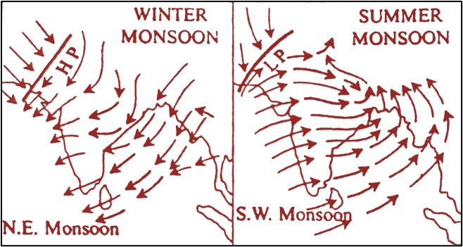
- In winter: Winds blew from north-east to south-west for about six months.
- In summer: Winds reversed, blowing from south-west to north-east for about six months.
Sailors noticed this exact and predictable reversal and began calling these winds mausim. Over time, geographers extended the term to all such winds across the globe that reverse direction between summer and winter.
Is Direction Change Enough to Call it a Monsoon?
Now here’s the twist — not every seasonal reversal of wind is called a monsoon.
For example:
- Between 60°–70° N latitude, in winter you get north-east polar winds, and in summer south-west westerlies.
- In the Mediterranean region (30°–40° latitudes), winter brings westerlies, and summer brings north-east trade winds.
Clearly, winds change direction here too — but we don’t call them monsoons.
Why? Because monsoon is not just about directional reversal. It’s also about the mechanism behind it.
The Real Basis of Monsoons – Thermal Mechanism
Monsoons are surface convective systems.
They are generated because land and ocean heat and cool at different rates (called differential heating and cooling). This causes large-scale thermal pressure differences, and these pressure differences make the winds reverse direction seasonally
Monsoon Climatic Regions
Wherever such winds dominate, we call it a monsoon climatic region.
- Strongest development: Indian subcontinent, South-East Asia, parts of China and Japan.
- Other regions with weaker monsoon-like winds (pseudo-monsoons): Southern USA, Northern Australia, Western Africa.
Scientific Definitions
Two important scholarly definitions help clarify:
- Chang-Chia Ch’eng:
A monsoon is a large-scale wind pattern where one wind direction dominates an entire region, but reverses (or almost reverses) from winter to summer and summer to winter. - Nieuwolt:
To call something a monsoon, the seasonal reversal must be strong and exceed at least 120° in wind direction.
In short
The monsoon is not just rain or just wind reversal. It’s a seasonally reversing wind system driven by differential heating of land and sea, and it’s most dramatically seen in the Indian subcontinent.
Concepts of the Origin of Monsoon
The question is simple: Why does the monsoon exist?
The answer, however, has gone through centuries of refinement. Broadly, two schools of thought explain its origin:
- Thermal Concept – based on heating and cooling differences between land and sea.
- Dynamic Concept – based on the movement and shifting of global wind systems.
Thermal Concept – The Oldest Theory
- First proposed by Halley in 1686.
- At that time, the world didn’t have satellite data or deep atmospheric studies — so the explanation was more straightforward:
The Earth’s surface is heterogeneous — it’s part land, part water.
These two heat and cool at different rates during the year.
This difference drives the monsoon.
How it Works – Winter vs. Summer
Let’s break it into the two halves of the year.
(a) Northern Hemisphere Winter (Winter Solstice)
- The Sun is overhead at the Tropic of Capricorn (southern hemisphere).
- In Asia, temperatures drop sharply → High-pressure zones form over land.
Two strong high-pressure centres:- Near Baykal Lake
- Near Peshawar
- In the southern Indian Ocean, it’s summer → Low-pressure centre forms.
Result:
Air flows from high pressure (Asia) to low pressure (southern Indian Ocean).
These winds are the North-East Monsoons (Winter Monsoons) — dry, because they come from land and don’t pick up much moisture.
(b) Northern Hemisphere Summer (Summer Solstice)
- The Sun is overhead at the Tropic of Cancer.
- Land in Asia heats up → Low-pressure centres develop:
- Near Baykal Lake
- Near Multan
- The southern Indian Ocean is now in winter → High-pressure centres develop:
- North of Australia
- South of Japan
Result:
Winds blow from Indian Ocean (high pressure) towards Asia (low pressure).
When they cross the equator, Ferrel’s Law deflects them to the right in the northern hemisphere → they become South-West Monsoons.
Now they pass over warm ocean water, pick up moisture, and release heavy rainfall when obstructed by mountains like the Western Ghats or Himalayas.
Why Scientists Later Questioned This Theory
Over time, meteorologists found that Halley’s purely thermal explanation didn’t fully match reality.
Main objections:
- Heat Lows Not Stationary:
If these low-pressure areas were only due to heating, they should stay fixed for a while. In reality, they shift suddenly — suggesting they’re part of cyclonic systems linked to the South-West Monsoon. - Rainfall Mechanism Doubt:
Heavy monsoon rainfall isn’t just because of the winds themselves — it often depends on tropical disturbances (like depressions and cyclones). - Upper-Air Patterns Ignored:
If monsoons were purely thermal, there should be an opposite “anti-monsoon” circulation in the upper atmosphere.
Indeed, scientists have found seasonal reversals in upper-level winds in the troposphere and stratosphere — a phenomenon called the Upper Air Monsoon or Aerological Monsoon.
✅ In essence: The thermal concept explained the monsoon in a simple way — land heats and cools faster than water, so pressure differences drive winds. But it missed the role of upper-air circulation, global wind belts, and cyclonic disturbances. That’s why the Dynamic Concept came later, offering a more complete picture.
Dynamic Concept of Monsoon Origin
Why this Concept Emerged
The Thermal Concept was simple but incomplete.
Meteorologist John rejected it on the basis of:
- The shifting nature of low-pressure zones.
- The role of large-scale atmospheric circulation that the thermal theory ignored.
He proposed that monsoons are not just about heating differences between land and sea, but rather about the seasonal shifting of the Earth’s major pressure and wind belts.
The Core Idea – Shifting of Pressure and Wind Belts
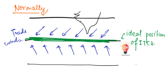
The Earth has a belt near the equator where the north-east trade winds from the northern hemisphere and the south-east trade winds from the southern hemisphere meet.
This zone is called the Intertropical Convergence (ITC).
- The northern boundary is called NITC (Northern Intertropical Convergence).
- The southern boundary is called SITC (Southern Intertropical Convergence).
Within this ITC lies a calm, low-pressure zone known as the doldrums, dominated by equatorial westerlies.
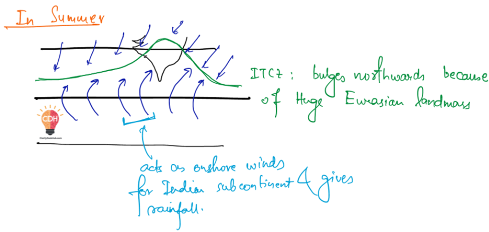
What Happens in Northern Summer (Summer Solstice – June 21)
- The Sun is directly overhead at the Tropic of Cancer.
- The NITC shifts northward — up to 30°N latitude — covering South Asia and South-East Asia.
- This means the equatorial westerlies now dominate these regions.
But here’s the key:
When these winds cross the equator into the northern hemisphere, Ferrel’s Law deflects them to the right — turning them into the South-West Monsoon. - These monsoon winds are moisture-laden, and the NITC zone itself is a breeding ground for atmospheric storms and cyclones, which add to the heavy rainfall between July and September.
What Happens in Northern Winter (Winter Solstice – December 22)
- The Sun moves south, overhead at the Tropic of Capricorn.
- The NITC shifts back southward — away from South and South-East Asia.
- As the ITC withdraws, the north-east trade winds re-establish themselves over the region.
- These north-east trades now act as the Winter Monsoon — dry winds coming from land, with little rainfall (except in certain coastal zones like Tamil Nadu, where they pick up moisture from the Bay of Bengal).
Key Difference from Thermal Concept
- Thermal Concept: Focuses mainly on land-sea heating contrast creating seasonal pressure differences.
- Dynamic Concept: Focuses on global atmospheric circulation and the seasonal migration of the ITC and associated wind belts.
✅ In essence:
The Dynamic Concept explains the monsoon as a global-scale shifting wind system, not just a regional heat-driven phenomenon.
The summer monsoon is the equatorial westerly displaced far north, while the winter monsoon is simply the re-established north-east trade winds after the ITC moves south.
Origin of Indian Monsoon – Modern Understanding
The Shift in Perspective
Before 1950, the monsoon was seen mainly as a surface-level wind system driven by land–sea heating differences — a fairly simple circulation model.
But after 1950, with better meteorological data (especially from upper-air observations), scientists realised the monsoon is actually a complex, multi-layered atmospheric mechanism involving:
- The Himalayas and Tibetan Plateau – acting both as a mechanical wall and a high-level heat source.
- Upper-air circum-polar whirls – massive cyclonic systems over the poles in the troposphere.
- Jet streams – powerful, high-altitude air currents influencing pressure zones.
- Differential heating of the Asian landmass and surrounding oceans – still important, but now seen as one part of a bigger puzzle.
Upper-Air Circum-Polar Whirls
Let’s imagine the poles in the upper troposphere:
- Surface: Extremely cold → high pressure due to descending dense air.
- Above the surface: A zone of low pressure develops.
This combination creates a large cyclonic circulation — the circum-polar whirl. - Winds in this whirl move in curved paths (cyclonic manner).
Jet Streams – The High-Speed Controllers
From these upper-air whirls, some winds move equatorward — these are the jet streams.
- They blow from west to east, following a meandering course (like a river with bends).
- Over Asia, these westerly jet streams play a crucial role in pushing pressure belts and influencing the onset of monsoon.
Winter Situation – Northern Hemisphere
- In northern winter (winter solstice), the Arctic circum-polar whirl becomes strong and shifts slightly southward.
- Westerly jet streams establish themselves between 20°N and 35°N latitude.
- This equatorward shift of the whirl pushes the NITC southward from its usual position.
- On the surface, the Indian subcontinent is dominated by north-east trade winds — i.e., the Winter Monsoon — bringing dry weather to most of India.
✅ Key takeaway:
Modern research shows the Indian monsoon is not just a surface heating story — it’s also about high-altitude atmospheric systems, especially how the jet streams and polar whirls interact with the Himalayas–Tibetan Plateau and shift the ITC seasonally.
Winter Season Conditions – Indian Monsoon Mechanism
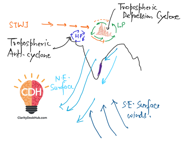
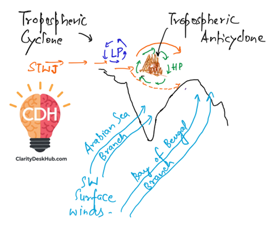
By now, we know that in northern winter, the upper-air westerly jet streams dominate over Asia. These winds blow at an altitude of about 12 km in the troposphere and are powerful influencers of India’s winter weather.
Jet Stream Bifurcation – The Himalayas Effect
When these jet streams approach the Himalayas and Tibetan Plateau, they split into two branches because the high mountain barrier blocks their direct path.
- Northern Branch – Moves west to east north of the Himalayas in a curved (arcuate) path.
- Southern Branch – Moves west to east south of the Himalayas.
Pressure Effects of the Two Branches
The split in jet streams causes very different pressure conditions north and south of the mountains:
- Northern Branch
Follows an anti-cyclonic arc (clockwise in the northern hemisphere).
→ Creates upper-air high pressure over Afghanistan and Pakistan (10–12 km altitude).
→ This high pressure forces winds to descend — leading to stable, dry conditions over north-western India. - Southern Branch
Follows a cyclonic arc (anticlockwise circulation) south of the Himalayas.
→ Creates upper-air low pressure over the Tibetan Plateau.
Equatorward Shift of the Polar Whirl
Because the north polar upper-air whirl shifts southwards in winter (October–February), the NITC is also pushed far to the south.
At the surface, India is dominated by north-east trade winds — the winter monsoon.
Winter Weather in India
- The high pressure over Afghanistan/Pakistan and descending dry air keep most of India stable and dry in winter.
- However, the upper-air westerly jet streams ride above temperate low-pressure systems (cyclonic waves) that travel from the Mediterranean → West Asia → Pakistan → North-West India.
Western Disturbances – Winter Rainfall in North India
- These disturbances are not frontal cyclones but upper-air waves at ~200 m above mean sea level.
- At the surface, north-east trades still blow.
- When these temperate disturbances arrive:
- Precipitation occurs (mostly light to moderate).
- Temperature drops abruptly.
- Clear weather returns after they pass.
- Frequency: About 4–8 disturbances per month from October to April.
- Reach: Affect weather up to Patna in Bihar.
- Nature of Rainfall: Mostly orographic — moist winds rise along the Himalayas, cool, and cause rain/snow.
Tamil Nadu’s Special Case
While most of India is dry in winter, Tamil Nadu gets significant rainfall in October–November.
Reason: The north-east monsoon winds cross the Bay of Bengal, pick up moisture, and release it along Tamil Nadu’s coast.
✅ Key Takeaway:
In winter, India’s weather is shaped by descending dry air from high-pressure zones, north-east trades at the surface, and occasional western disturbances that bring short bursts of rain to north-west and north India. Only Tamil Nadu benefits from steady rainfall in this season.
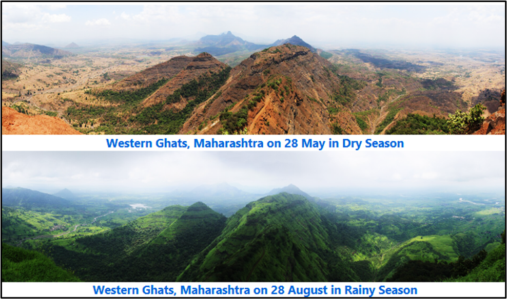
Summer Season Conditions – Onset of the South-West Monsoon
From March to June, the Sun’s northward movement triggers dramatic changes in India’s atmospheric circulation.
Seasonal Solar Shift
- After Vernal Equinox (21 March) → Sun moves northward.
- Summer Solstice (21 June) → Sun is directly overhead at the Tropic of Cancer.
- Consequences:
- Polar high pressure weakens → Upper-air circum-polar whirl retreats northward.
- Westerly jet streams shift north → Indian skies are free of the winter jet stream influence by mid-June.
- Southern branch withdrawal → Removes dynamic suppression over India, allowing surface low pressure to dominate.
Formation of Pre-Monsoon Low Pressures
- April–May:
- Surface low pressure develops over NW Pakistan & NW India due to intense heating.
- BUT — as long as the southern branch of the westerly jet still lies south of the Himalayas:
- Descending air from upper-air high pressure prevents vertical uplift.
- This suppresses rainfall → Hot & dry “loo” winds dominate.
- Myanmar branch rains:
- Monsoon reaches Myanmar in May → Brings rain to NE India & Bangladesh (pre-monsoon showers).
- NW India remains dry until jet stream withdrawal.
Transition to Monsoon Conditions
- By mid-June:
- Southern branch of the westerly jet fully withdrawn north of Tibet.
- Flow curvature over Iran & Afghanistan becomes cyclonic (anticlockwise).
- This creates an upper-air tropospheric low over Iran–Afghanistan → extends into Pakistan & NW India.
- At the surface, a thermally induced low already exists in the same region.
Burst of the South-West Monsoon
- The upper-air low acts like a “vacuum pump,” sucking air upward from the surface low.
- This triggers:
- Sudden onset of moist south-westerlies from the Arabian Sea and Bay of Bengal.
- Rapid spread of monsoon rains across India.
✅ Key Takeaway:
The onset of the SW monsoon is not just about surface heating — it’s the combined effect of:
- Retreat of the westerly jet streams
- Cyclonic curvature aloft over West Asia
- Alignment of upper and lower tropospheric lows
- Moist air advection from the oceans
Role of the Southern Hemisphere in the Indian Monsoon
Seasonal Hemispheric Contrast
- Northern Summer (June–Sept) = Southern Hemisphere Winter.
- The Southern Polar Whirl strengthens and expands equatorward.
- This pushes the Intertropical Convergence (ITC) northward beyond the equator.
Cross-Equatorial Flow
- South-East Trade Winds are driven northward across the equator.
- Due to the Coriolis effect (to the right in the Northern Hemisphere):
- They are deflected → Become South-Westerlies.
- These winds rush towards the Indian subcontinent, carrying oceanic moisture.
Push Factor vs. Suction Factor
- Rapid northward movement of the ITC is mainly due to the “push” from the Southern Polar Whirl.
- The traditional “suction” explanation from the thermal low over NW India is secondary.
ITC & Rainfall Variability
- The ITC is not a static line — it contains dynamically induced cyclonic vortices.
- Wet phases → When vortices reach India.
- Dry spells → When vortices dissipate (occlusion) before arrival.
Spatial and Temporal Variation of Monsoon Rainfall in India
Arabian Sea Branch
- Western Ghats (windward side) → Orographic lift causes heavy rainfall.
- Leeward side (rain-shadow regions) →
- Winds descend → warm adiabatically → low relative humidity → scant rainfall.
- Example: Eastern Maharashtra, North Karnataka, Interior Tamil Nadu.
Bay of Bengal Branch
- The Himalayas influence in two ways:
- Orographic uplift → heavy rainfall in foothills & NE India.
- Channeling effect → Winds deflected westward along Himalayan foothills → monsoon penetration into NW India via Ganga Valley.
Rajasthan Rainfall Puzzle
- Despite strong surface low over Rajasthan–Pakistan:
- Low rainfall due to:
- Shallow depth of monsoon current.
- Upper-air dynamic anticyclonic conditions above surface low suppressing uplift.
- Low rainfall due to:
- Exception:
- When upper-air high pressure shifts westward, monsoon winds can rise → occasional heavy rain even in Rajasthan.
MONEX – Monsoon Experiment (1973)
Background
- Joint Indo–Soviet scientific programme.
- Objective: Study onset, strength, and variability of Indian monsoon using field observations.
Key Findings
- Tibetan Plateau plays a critical role in monsoon dynamics:
- Mechanical barrier → Diverts upper-air circulation.
- High-level heat source → Intensifies upper-tropospheric thermal lows.
- Plateau characteristics:
- Width: 1,000 km (E), 600 km (W)
- Length: 2,000 km
- Average elevation: 4,000 m.
- Confirmed that heating & cooling cycles of the plateau directly influence:
- Onset timing
- Rainfall strength
- Intra-seasonal variability.
✅ Final Integration Point:
The Indian monsoon is a multi-scale, multi-factor phenomenon — influenced simultaneously by local thermal contrasts, upper-air circulation shifts, cross-equatorial push from the Southern Hemisphere, and orographic effects. MONEX confirmed that upper-tropospheric processes over the Tibetan Plateau are as important as surface heating in controlling monsoon behaviour.
Retreating Monsoon Explained:
- Southwest (S-W) Monsoon is the Primary Rain-Bringer
- India receives most of its rainfall from the Southwest Monsoon.
- This monsoon originates from the Indian Ocean and brings moisture-laden winds to the subcontinent.
- Northeast (N-E) Monsoon Brings Limited Rainfall
- Unlike the S-W Monsoon, the Northeast Monsoon does not contribute much to rainfall in India.
- Exception: Tamil Nadu (TN) receives significant rainfall during the N-E Monsoon.
- Northeast (N-E) Monsoon Season: October to March
- The N-E Monsoon lasts from October to March.
- Within this period, the months of October and November are considered the Retreating Monsoon, which is a subset of the N-E Monsoon season.
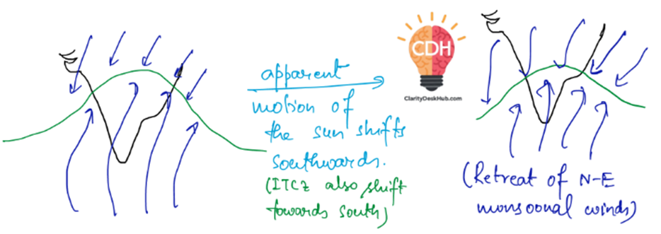
Seasonal Changes Affecting Monsoon Winds
In Summer (June–September)
- The Sun moves northward, shifting the Inter-Tropical Convergence Zone (ITCZ) northward.
- This shift pulls the S-W Monsoon winds towards India, bringing heavy rains.
In Winter (Post-September)
- The Sun moves southward, causing the ITCZ to shift southward as well.
- As a result, the Southwest Monsoon retreats, and winds start blowing from the northeast.
- This retreat marks the beginning of the Northeast Monsoon.
- Since these winds originate from the land (Indian subcontinent), they are dry and do not bring rainfall—except in Tamil Nadu, where they pick up moisture from the Bay of Bengal.
So, Let’s summarise:
- Retreating Monsoon occurs in October–November as part of the Northeast Monsoon season.
- S-W Monsoon (June–September) brings major rainfall to India, while N-E Monsoon (October–March) brings rain mainly to Tamil Nadu.
- The shift of the ITCZ southward due to the apparent motion of the Sun leads to the retreat of monsoon winds.
- The Northeast Monsoon winds are dry, as they originate from land, except when they pick up moisture over the Bay of Bengal before reaching Tamil Nadu.
This process explains why India experiences a distinct retreating monsoon phase before transitioning into winter.
Explanation of October Heat
- What is October Heat?
- During October, as the Sun starts moving southward, the Southwest Monsoon retreats from India.
- However, the land is still heated, and combined with high humidity from the ocean, this creates a period of hot and humid weather—known as October Heat.
- It is less severe than the Loo (hot, dry summer winds), but still uncomfortable due to high moisture in the air.
- Role of Air Currents
- A Low-Pressure (LP) zone forms over land during monsoon due to intense heating.
- As the monsoon withdraws, High Pressure (HP) builds up over land, pushing air downwards.
- This descending air increases the warming effect, but not as extreme as in summer.
- Why is October Heat Not as Intense as Loo?
- In summer, Loo (hot winds) occurs due to extreme heating of dry air over land.
- In contrast, October Heat occurs when the retreating monsoon leaves behind moist air from the ocean, making it humid but not as dry or scorching as Loo
8 Comments